
Kandy is a major city in Sri Lanka located in the Central Province. It was the last capital of the ancient kings' era of Sri Lanka. The city lies in the midst of hills in the Kandy plateau, which crosses an area of tropical plantations, mainly tea. Kandy is both an administrative and religious city and is also the capital of the Central Province. Kandy is the home of the Temple of the Tooth Relic, one of the most sacred places of worship in the Buddhist world. It was declared a world heritage site by UNESCO in 1988.

Nuwara Eliya is a city in the hill country of the Central Province, Sri Lanka. Its name means "city on the plain " or "city of light". The city is the administrative capital of Nuwara Eliya District, with a picturesque landscape and temperate climate. It is at an altitude of 1,868 m (6,128 ft) and is considered to be the most important location for tea production in Sri Lanka. The city is overlooked by Pidurutalagala, the tallest mountain in Sri Lanka. Nuwara Eliya is known for its temperate, cool climate – the coolest area in Sri Lanka.

Horton Plains National Park is a protected area in the central highlands of Sri Lanka and is covered by montane grassland and cloud forest. This plateau at an altitude of 2,100–2,300 metres (6,900–7,500 ft) is rich in biodiversity and many species found here are endemic to the region. This region was designated a national park in 1988. It is also a popular tourist destination and is situated 8 kilometres (5.0 mi) from Ohiya, 6 kilometres (3.7 mi) from the world-famous Ohiya Gap/Dondra Watch and 32 kilometres (20 mi) from Nuwara Eliya.
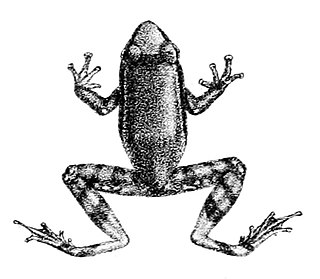
Pseudophilautus hypomelas is a species of frog in the family Rhacophoridae endemic to Sri Lanka. It is sometimes referred to as the webless shrub frog. In 2004 it was declared extinct by the International Union for Conservation of Nature when, despite extensive field efforts, no specimen had been seen in the wild after the species was described by Albert Günther in 1876. However, this frog was rediscovered in 2010 in the Peak Wilderness, a highly biodiverse area in the Central Highlands of Sri Lanka. Thus, this species had been "lost" for more than 130 years.

Ambewela is a small town, or a hill station, located in the Nuwara Eliya District of Sri Lanka. The area is also sometimes called "Little New Zealand". The town is situated approximately 17 km (11 mi) south-east of the district capital Nuwara Eliya. Ambewela is also a service center to the New Galway tea planting district.
Protected areas of Sri Lanka are administrated by Department of Forest Conservation and Department of Wildlife Conservation of Sri Lanka.There are 501 protected areas in Sri Lanka. The protected areas falls under supervision Department of Forest Conservation include forests defined in National Heritage Wilderness Area Act in 1988, forest reservations and forests manage for sustainability. World heritage site, Sinharaja Forest Reserve is an example for a National Heritage forest. There are 32 forests categorized as conservation forests including Knuckles Mountain Range. Strict nature reserves, national parks, nature reserves, forest corridors and sanctuaries recognized under the Flora and Fauna Protection Ordinance are managed by Department of Wildlife Conservation. Total of all categories of areas protected is 1,767,000 ha. Protected areas in Sri Lanka accounts for 26.5 percent of total area. This is a higher percentage of protected areas than in all of Asia and much of the World.

Bundala National Park is an internationally important wintering ground for migratory water birds in Sri Lanka. Bundala harbors 197 species of birds, the highlight being the greater flamingo, which migrate in large flocks. Bundala was designated a wildlife sanctuary in 1969 and redesignated to a national park on 4 January 1993. In 1991 Bundala became the first wetland to be declared as a Ramsar site in Sri Lanka. In 2005 the national park was designated as a biosphere reserve by UNESCO, the fourth biosphere reserve in Sri Lanka. The national park is situated 245 kilometres (152 mi) southeast of Colombo.

Field Ornithology Group of Sri Lanka, commonly abbreviated FOGSL, is the Sri Lankan affiliate of BirdLife International. It was founded in 1976 to promote the conservation of birds and preservation of the environment. FOGSL headquarters are situated in the Department of Zoology, University of Colombo, Sri Lanka. Its president is Professor Sarath Kotagama
Nuwara Eliya electoral district is one of the 22 multi-member electoral districts of Sri Lanka created by the 1978 Constitution of Sri Lanka. The district is conterminous with the administrative district of Nuwara Eliya in the Central province. The district currently elects 7 of the 225 members of the Sri Lankan Parliament and had 457,137 registered electors in 2010.

The Hill Club is a gentlemen's club in Nuwara Eliya, Sri Lanka. Established 1876 by British coffee planters in the hill station of Nuwara Eliya.
Totapolakanda, is the third highest mountain in Sri Lanka situated in Nuwara Eliya district 2,357 m (7,733 ft) above mean sea level. The mountain is located within the Horton Plains National Park. A trail to the top of the mountain, about two kilometres long, starts a few metres away from the Pattipola entrance to the Horton Plains National Park. Most parts of the mountain surface is covered with shrubs adapted to the cool and windy climate of Horton Plains National Park. Strobilanthes, Osbeckia and Rhodomyrtus species grown as shrubs are common among them.

Talawakelle is a town in Nuwara Eliya District in the Central Province, Sri Lanka, governed by an Urban Council. It is the center of Dimbula tea planting district, the largest tea growing area in Sri Lanka. It is situated on A7 colombo-Nuwara Eliya highway. The altitude of Talawakelle is 1,198 metres (3,930 ft). Talawakelle railway station is one of the major stops of Udarata or Main railway line. The town is administrated by Talawakelle-Lindula urban council.
Sri Ranga Jeyaratnam is a Sri Lankan Tamil broadcaster, politician and former Member of Parliament.
Sundaram Perumal Rajadurai is a Sri Lankan attorney-at-law, politician and former Member of Parliament.
Akandhan Velusami Radhakrishnan is a Sri Lankan politician and state minister. He is the leader of the Up-Country People's Front (UCPF), a member of the Tamil Progressive Alliance (TPA) and United National Front for Good Governance (UNFGG).

Victoria Park is a public park located in Nuwara Eliya, next to the Nuwara Eliya Post Office in Sri Lanka.
S. Udeiappan Palani Alagan Digambaran is a Sri Lankan politician and government minister. He is the leader of the National Union of Workers (NUW), a member of the Tamil Progressive Alliance (TPA) and United National Front for Good Governance (UNFGG).
Kotagala electoral district was an electoral district of Sri Lanka between August 1947 and March 1960. The district was named after the town of Kotagala in Nuwara Eliya District, Central Province. The 1978 Constitution of Sri Lanka introduced the proportional representation electoral system for electing members of Parliament. The existing 160 mainly single-member electoral districts were replaced with 22 multi-member electoral districts. Kotagala electoral district was replaced by the Nuwara Eliya multi-member electoral district at the 1989 general elections, the first under the proportional representation system.
Nuwara Eliya electoral district was an electoral district of Sri Lanka between August 1947 and July 1977. The district was named after the City of Nuwara Eliya in Nuwara Eliya District, Central Province. The 1978 Constitution of Sri Lanka introduced the proportional representation electoral system for electing members of Parliament. The existing 160 mainly single-member electoral districts were replaced with 22 multi-member electoral districts. Nuwara Eliya electoral district was replaced by the Nuwara Eliya multi-member electoral district at the 1989 general elections, the first under the proportional representation system, Nuwara Eliya continues to be a polling division of the multi-member electoral district.
Nuwara Eliya-Maskeliya electoral district was an electoral district of Sri Lanka between July 1977 and February 1989. The district was named after the city of Nuwara Eliya and town of Maskeliya in Nuwara Eliya District, Central Province. The 1978 Constitution of Sri Lanka introduced the proportional representation electoral system for electing members of Parliament. The existing 160 mainly single-member electoral districts were replaced with 22 multi-member electoral districts. Nuwara Eliya-Maskeliya electoral district was replaced by the multi-member electoral district at the 1989 general elections, the first under the proportional representation system.

