The Andaman Sea is a marginal sea of the northeastern Indian Ocean bounded by the coastlines of Myanmar and Thailand along the Gulf of Martaban and west side of the Malay Peninsula, and separated from the Bay of Bengal to its west by the Andaman Islands and the Nicobar Islands. Its southern end is at Breueh Island just north of Sumatra, with the Strait of Malacca further southeast.

The Florida Keys National Marine Sanctuary is a U.S. National Marine Sanctuary in the Florida Keys. It includes the Florida Reef, the only barrier coral reef in North America and the third-largest coral barrier reef in the world. It also has extensive mangrove forest and seagrass fields. The Florida Keys National Marine Sanctuary, designated in 1990, is the ninth national marine sanctuary to be established in a system that comprises 13 sanctuaries and two marine national monuments. The Florida Keys National Marine Sanctuary protects approximately 2,900 square nautical miles of coastal and ocean waters from the estuarine waters of south Florida along the Florida Keys archipelago, encompassing more than 1,700 islands, out to the Dry Tortugas National Park, reaching into the Atlantic Ocean, Florida Bay and the Gulf of Mexico.

White band disease is a coral disease that affects acroporid corals and is distinguishable by the white band of exposed coral skeleton that it forms. The disease completely destroys the coral tissue of Caribbean acroporid corals, specifically elkhorn coral and staghorn coral. The disease exhibits a pronounced division between the remaining coral tissue and the exposed coral skeleton. These symptoms are similar to white plague, except that white band disease is only found on acroporid corals, and white plague has not been found on any acroporid corals. It is part of a class of similar disease known as "white syndromes", many of which may be linked to species of Vibrio bacteria. While the pathogen for this disease has not been identified, Vibrio carchariae may be one of its factors. The degradation of coral tissue usually begins at the base of the coral, working its way up to the branch tips, but it can begin in the middle of a branch.

The Mesoamerican Barrier Reef System (MBRS), also popularly known as the Great Mayan Reef or Great Maya Reef, is a marine region that stretches over 1,126 kilometres (700 mi) along the coasts of four countries – Mexico, Belize, Guatemala, and Honduras – from Isla Contoy at the northern tip of the Yucatán Peninsula south to Belize, Guatemala and the Bay Islands of Honduras. The reef system includes various protected areas and parks including the Belize Barrier Reef, Arrecifes de Cozumel National Park, Hol Chan Marine Reserve (Belize), Sian Ka'an biosphere reserve, and the Cayos Cochinos Marine Park. Belize's coastline, including the Belize Barrier Reef, is home to approximately 30% of the Mesoamerican Barrier Reef System.
The Gulf of Mannar Marine National Park is a protected area of India consisting of 21 small islands (islets) and adjacent coral reefs in the Gulf of Mannar in the Indian Ocean. It lies 1 to 10 km away from the east coast of Tamil Nadu, India for 160 km between Thoothukudi (Tuticorin) and Dhanushkodi. It is the core area of the Gulf of Mannar Biosphere Reserve which includes a 10 km buffer zone around the park, including the populated coastal area. The park has a high diversity of plants and animals in its marine, intertidal and near shore habitats. Public access inside the park is limited to glass-bottom boat rides. It was established as a National Park in 1986.

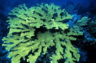
The staghorn coral is a branching, stony coral with cylindrical branches ranging from a few centimetres to over two metres in length and height. It occurs in back reef and fore reef environments from 0 to 30 m depth. The upper limit is defined by wave forces, and the lower limit is controlled by suspended sediments and light availability. Fore reef zones at intermediate depths 5–25 m (16–82 ft) were formerly dominated by extensive single-species stands of staghorn coral until the mid-1980s. This coral exhibits the fastest growth of all known western Atlantic fringe corals, with branches increasing in length by 10–20 cm (3.9–7.9 in) per year. This has been one of the three most important Caribbean corals in terms of its contribution to reef growth and fishery habitat.

Hol Chan Marine Reserve is a marine reserve close to Ambergris Caye and Caye Caulker, off the coast of Belize. It covers approximately 18 km² (4,448 acres) of coral reefs, seagrass beds, and mangrove forest. Hol Chan is Mayan for "little channel".
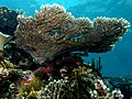
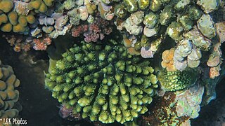
Elkhorn coral is an important reef-building coral in the Caribbean. The species has a complex structure with many branches which resemble that of elk antlers; hence, the common name. The branching structure creates habitat and shelter for many other reef species. Elkhorn coral is known to grow quickly with an average growth rate of 5 to 10 cm per year. They can reproduce both sexually and asexually, though asexual reproduction is much more common and occurs through a process called fragmentation.
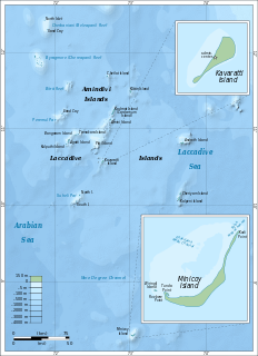
Kadmat Island, also known as Cardamom Island, is a coral island belonging to the Amindivi subgroup of islands of the Lakshadweep archipelago in India. Measuring 9.3 kilometres (5.8 mi) in length, the island has a lagoon with a width of 1.5 kilometres (0.93 mi) covering an area of 25 square kilometres (9.7 sq mi). The ecological feature of the island is of coral reef with seagrass, and marine turtles which nestle here. The Ministry of Environment and Forests (India) has notified the island as a marine protected area for ensuring conservation of the island's animal, plant, or other type of organism, and other resources.
The fishing industry in the Maldives is the island's second main industry. According to national tradition in the words of former President Maumoon Abdul Gayoom, "Fishing is the lifeblood of our nation, it is inborn. From the soil on which we live, to the sea around us, it remains an integral part of our existence. Fishing, and our country and its people, [are] one and shall remain inseparable forever." The Maldives has an abundance of aquatic life and species of fish. Common are tuna, groupers, dolphin fish, barracuda, rainbow runner, trevally and squirrelfish and many more. Aside from being of essential importance to the economy, fishing is also a popular recreational activity in the Maldives, not only among locals but by tourists. The islands have numerous fishing resorts which cater for these activities.
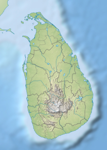
Pigeon Island National Park is one of the two marine national parks of Sri Lanka. The national park is situated 1 km off the coast of Nilaveli, a coastal town in Eastern Province, encompassing a total area of 471.429 hectares. The island's name derives from the rock pigeon which has colonized it. The national park contains some of the best remaining coral reefs of Sri Lanka. Pigeon Island was designated as a sanctuary in 1963. In 2003 it was re-designated as a national park. This national park is the 17th in Sri Lanka. The island was used as a shooting range during the colonial era. Pigeon Island is one of the several protected areas affected by the Indian Ocean tsunami in 2004.

Lunugamvehera National Park in Sri Lanka was declared in 1995, with the intention of protecting the catchment area of the Lunugamvehera reservoir and wildlife of the area. The national park is an important habitat for water birds and elephants. The catchment area is vital to maintain the water levels of the five tanks in the down stream of Kirindi Oya and wetland characteristics of Bundala National Park. This national park also serves as a corridor for elephants to migrate between Yala National Park and Udawalawe National Park. The national park is situated 261 km (162 mi) southwest from Colombo. After being closed because of the Sri Lankan civil war, the national park is now open to the general public.
Lahugala Kitulana National Park is one of the smallest national parks in Sri Lanka. Despite its land area, the park is an important habitat for Sri Lankan elephant and endemic birds of Sri Lanka. The national park contains the reservoirs of Lahugala, Kitulana and Sengamuwa and they are ultimately empties to Heda Oya river. Originally it was designated as a wildlife sanctuary on July 1 of 1966. Then the protected area was upgraded to a national park on October 31 of 1980. Lahugala Kitulana is situated 318 km east of Colombo.

Kaudulla National Park is a national park on the island of Sri Lanka located 197 kilometres (122 mi) away from the largest city, Colombo. It was designated a national park on April 1, 2002 becoming the 15th such area on the island. In the 2004–2005 season more than 10,000 people visited the National Park, generating an income of Rs.100,000 from entrance fees. Along with Minneriya and Girithale BirdLife International have identified Kaudulla as an Important Bird Area.
Wakatobi National Park is a marine national park in Southeast Sulawesi, Indonesia. The name of Wakatobi is a portmanteau of the four main Tukangbesi Islands: Wangi-wangi, Kaledupa, Tomia, and Binongko. Since 2005 the park is listed as a tentative World Heritage Site.
The St. Croix East End Marine Park (STXEEMP) was established to "protect territorially significant marine resources, and promote sustainability of marine ecosystems, including coral reefs, sea grass beds, wildlife habitats and other resources, and to conserve and preserve significant natural areas for the use and benefit of future generations." It is the U.S. Virgin Islands’ first territorially designated and managed marine protected area (MPA).
Nosy Ve-Androka National Park is a Protected Marine Area located in the southwestern part of Madagascar, south of Tulear, and 40 km south of the tourist village of Anakao. It lies between latitudes 25 ° 29/25 ° 09 South and longitudes 44 ° 50/45 ° 06 East and covers an area of 92080 ha. It is composed of Core Areas totalling 28,820 ha and Buffer Zones totalling 63,260 ha. The park is made up of eight parcels in two clusters, with part found along the coast adjacent to Tsimanampetsotsa National Park. It includes sections of the rich coral reef system of South West Madagascar in the Mozambique Channel, recognized as the third largest reef system in the world. Diversity of habitats include fringing reefs, barrier reefs, coral reef beds, seagrass area, open sea, rocky coast and sandy beaches. The Nosy Ve-Androka National Park contains about 140 species of coral and 240 species of fish. There are also rare species such as Coelacanths, marine turtle species, dugongs, dolphins and whales and sandy beaches that are used by nesting sea turtles.

The Bonaire National Marine Park or BNMP is one of the oldest marine reserves in the world. It includes the sea around Bonaire and Klein Bonaire from the high water line to a depth of sixty meters. The park was established in 1979 and covers 2700 hectares coral reef, seagrass - and mangrove vegetation. The lagoon Lac is also part of the underwater park.
The East African coral coast is a marine ecoregion along the eastern coast of Africa. It extends along the coasts of Kenya, Tanzania, and northern Mozambique, from Lamu in Kenya to Angoche in Mozambique. It adjoins the Northern Monsoon Current Coast ecoregion to the north, and the Bight of Sofala/Swamp Coast ecoregion to the south.
The Northern Monsoon Current coast is a marine ecoregion along the eastern coast of Africa. It extends along a portion of the coasts of Somalia and Kenya, from south of Lamu in Kenya to north of Mogadishu in Somalia. It adjoins the Central Somali coast ecoregion to the north, and the East African coral coast ecoregion to the south.