This article needs additional citations for verification .(February 2025) |
Gangapur City | |
|---|---|
 | |
| Nickname: Kushalgarh | |
 Gangapur City  Gangapur City Gangapur City (India) | |
| Coordinates: 26°28′18″N76°42′57″E / 26.47171°N 76.71594°E | |
| Country | |
| State | Rajasthan |
| District | Sawai Madhopur |
| Kushalgarh | 1757 CE |
| Founded by | Raja Kushaliram Haldiya |
| Named after | Gangaram (brother of Raja Kushaliram) |
| Government | |
| • Type | Government of Rajasthan |
| • Body | Nagar Parishad |
| • MLA | Ramkesh Meena (INC) |
| • Chairman | Shivratan Agrawal (BJP) |
| Area | |
• Total | 32 km2 (12 sq mi) |
| Elevation | 260 m (850 ft) |
| Population (2023) | |
• Total | 165,000 |
| • Density | 5,200/km2 (13,000/sq mi) |
| Languages | |
| • Official | Hindi |
| • Native | Braj Bhasha, Dhundhari (Rajasthani) |
| Time zone | UTC+5:30 (IST) |
| PIN | 322201,322202 |
| Telephone code | 07463 |
| Vehicle registration | RJ-25 |
| Sex ratio | 892 per 1000 ♂/♀ |
| Website | |
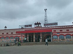
Gangapur City is a municipal council located in Sawai Madhopur district in the eastern part of Indian state of Rajasthan. It is situated 140 km (87 mi) east of Rajasthan's capital Jaipur, 76 km (47 mi) from Sawai Madhopur, 33 km (20 mi) from Karauli, 160 km (99 mi) from Agra of Uttar Pradesh. It is famous for its sweet cuisine Kheermohan and newly built Kushalgarh Baba Shyam Temple.
Contents
- History
- Geography
- Demographics
- Language
- Literacy rates
- Religions
- Climate
- Business
- Administration and politics
- Transportation
- Railways
- Roadways
- Airways
- See also
- External links
- References
Gangapur City holds a strategic position due to its location on the Delhi–Mumbai railway route, making it an important transportation hub. The city is well-connected to major urban centers like Jaipur, Kota, and Agra. Its proximity to attractions like Ranthambore National Park adds to its importance in the area.