Sawai Madhopur district

Last updated

Sawai Madhopur district
36 Pillars Chhatri - Ranthambore Fort, Sawai Madhopur.jpg
Pond Lahkod.jpg
SWM 2.jpg
Shiwar.jpg
Aravali range inside Ranthambhore, Rajasthan.jpg
Clockwise from top-left: 36 Pillar Chhatri in Ranthambore Fort, Temple tank near Lakhod, Ghushmeshwar Temple in Shiwar, Aravalli Range in Ranthambore Tiger Reserve, Watchtower near Sawai Madhopur
Sawai Madhopur in Rajasthan (India).svg
Location of Sawai Madhopur district in Rajasthan
CountryFlag of India.svg  India
State Rajasthan
Division Bharatpur
Headquarters Sawai Madhopur
Government
   District collector Suresh Kumar Ola
Area
  Total10,527 km2 (4,064 sq mi)
Population
 (2011) [1]
  Total1,335,551
  Density130/km2 (330/sq mi)
Demographics
   Literacy 65.39
  Sex ratio897
Time zone UTC+05:30 (IST)
Website sawaimadhopur.rajasthan.gov.in

Sawai Madhopur district is a district of Rajasthan state in north-west India. Sawai Madhopur is the chief town and district headquarters. Sawai Madhopur district comes under Bharatpur division. [2]

Contents

Geography

Sawai Madhopur District has an area of 10527 km2. It is bounded by Dausa district on the north, Karauli district on the northeast, Sheopur district of Madhya Pradesh to the southeast, Kota and Bundi districts on the south, and Tonk district on the west.

The Aravalli Hills are found in this district, in which is the famous Ranthambore Tiger Reserve. The Chambal River forms the southeastern boundary of the district.

Division

Sawai Madhopur district has 5 revenue subdivisions and 6 tehsils: [3]

Sawai Madhopur District: Revenue Scheme
SubdivisionLand Record
Circles (ILRCs)
Patwar CirclesVillages
Total
Sawai Madhopur748152
Chauth Ka Barwara 32464
Khandar637128
Bonli431104
Malarna Dungar32476
Gangapur City32485
Wazeerpur32444
Bamanwas755150

District Court

Sawai Madhopur District Court was established on 1977. Shri O.P. Jain took over the charge of first Sawai Madhopur District & Session Court judge. Presently Sh. Ajai kumar Ojha is the District & Sessions Judge of Sawai Madhopur. There are 10 judges in the Sawai Madhopur District Court.

Economy

In 2006 the Ministry of Panchayati Raj named Sawai Madhopur one of the country's 250 most backward districts (out of a total of 640). [4] It is one of the 12 districts in Rajasthan currently receiving funds from the Backward Regions Grant Fund Programme (BRGF). [4]

Demographics

Historical population
YearPop.±% p.a.
1901264,632    
1911262,575−0.08%
1921236,115−1.06%
1931259,852+0.96%
1941293,648+1.23%
1951329,206+1.15%
1961421,063+2.49%
1971537,675+2.47%
1981688,360+2.50%
1991875,752+2.44%
20011,117,057+2.46%
20111,335,551+1.80%
source: [5]
Religions in residual Sawai Madhopur district (2011) [6]
ReligionPercent
Hinduism
86.70%
Islam
11.91%
Jainism
1.04%
Other or not stated
0.35%

According to the 2011 census Sawai Madhopur district has a population of 1,335,551, [1] roughly equal to the nation of Mauritius [7] or the US state of Maine. [8] This gives it a ranking of 362nd in India (out of a total of 640). [1] The district has a population density of 297 inhabitants per square kilometre (770/sq mi) . [1] Its population growth rate over the decade 2001-2011 was 19.79%. [1] Sawai Madhopur has a sex ratio of 894 females for every 1000 males, [1] and a literacy rate of 66.19%. 19.95% of the population lives in urban areas. Scheduled Castes and Scheduled Tribes make up 20.87% and 21.40% of the population respectively. [1]

After reorganisation, the residual district has a population of 817,289. The residual district has a sex ratio of 908 females per 1000 males. 136,406 (16.69%) lived in urban areas. Scheduled Castes and Scheduled Tribes made up 173,831 (21.27%) and 175,113 (21.43%) of the population respectively. [1]

The largest community in the district is the Jats, while the Yadav are a significant population. Of the Dalits, the Bairwa are the largest population making up approximately half the total SC population. [9] [1]

The District is dominant by Jats community and yadavs are also in sizeable number. and as per the census of India 2011, Jats population is 4.85 lakh and yadavs are 1.95 lac, these both caste play key role in Lok Sabha election. In Tonk-Sawai Madhopur Lok Sabha constituency, Jats voters are 4 lakh, Muslims 2.85 lakh, yadavs 1.75 lakh, 2.1 lakh SC and 2 lakh ST. [10]

Languages of residual Sawai Madhopur district (2011) [11]

   Hindi (89.30%)
   Rajasthani (5.23%)
   Urdu (3.67%)
   Dhundhari (0.97%)
  Others (0.83%)

At the time of the 2011 Census of India, 89.30% of the population in the district spoke Hindi, 5.23% Rajasthani, 3.67% Urdu and 0.97% Dhundhari as their first language. [11] The main dialect of the district is Dhundari.

Fairs and festivals

Ganesh Chaturthi Fair

Ganesh Chaturthi Fair is the largest fair of Sawai Madhopur. It is organised on Bhadav Shukla Chaturthi at Ganesh Temple, Ranthambhore Fort. People of Rajasthan and outside Rajasthan visit for this fair. Every year 3-4 lacs devotees participates in this fair. This fair is organised for three days.

Chauth Mata Fair

Chauth Mata Temple is about 25 km from the Sawai Madhopur city in Chauth Ka Barwara town. This fair is organised on Magh Krishna Chaturthi. Lacs of people around Rajasthan and other states visit here for this Fair.

Shiv Ratri Fair

The Ghushmeshwar Mahadev temple is located 3 km from Isarda Railway Station in Kota-Jaipur on the train route to Shiwar Town, at 100 km from Jaipur and 40 km from Sawai Madhopur in Rajasthan, India, near Ranthambore National Park. Annual fair is organised near the temple during Shiv Ratri. [12] [13]

Rameshwar Dham

The Rameshwaram Temple is 60 km from Sawai Madhopur on the confluence of Banas and Chambal River. It has a Shiva temple where a fair is held annually on Shiv Ratri. Lakhs of people Rajasthan and Madhya Pradesh visit here for this Fair.

KalyanJi Fair

Every year the Besakh Shukla Puranmasi fair is organised at Gangapur City for seven days. Thousands of people join this fair.

Chamatkarji fair

A fair is organised at Chamatkarji on Sharad Purnima. [14]

See also

Related Research Articles

<span class="mw-page-title-main">Ranthambore National Park</span> National park in Rajasthan, India

Ranthambore National Park is a national park in Rajasthan, India, with an area of 1,334 km2 (515 sq mi). It is bounded to the north by the Banas River and to the south by the Chambal River. It is named after the historic Ranthambore Fort, which lies within the park.

<span class="mw-page-title-main">Sawai Madhopur</span> City in Rajasthan, India

Sawai Madhopur is a Tier-3 city and Municipal Council in the Sawai Madhopur District in Rajasthan state, India. It is the administrative headquarter of Sawai Madhopur District in Rajasthan. Ranthambore National Park which is 13 km from the railway station, and Ranthambore Fort, a UNESCO World Heritage Site are located near Sawai Madhopur.

<span class="mw-page-title-main">Karauli district</span> District of Rajasthan, India

Karauli District is a district of the state of Rajasthan in western India. It is located in the Braj Bhoomi region. The town of Karauli serves as the administrative headquarters of the district. Karauli district also comes under the Bharatpur Divisional Commissionerate.

<span class="mw-page-title-main">Gangapur City</span> City in Rajasthan, India

Gangapur is a city and a municipal council located in Gangapur City District in the Indian state of Rajasthan. It is the administrative headquarters of Gangapur City District. It is Famous for its Sweet Cuisine "Kheermohan" and newly built Kushalgarh Baba Shyam Temple.

<span class="mw-page-title-main">Ranthambore Fort</span> Fort in Sawai Madhopur, Rajasthan, India

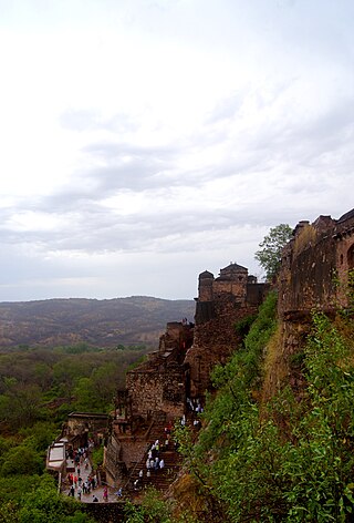
Ranthambore Fort lies within the Ranthambore National Park, near the city of Sawai Madhopur in Sawai Madhopur district of Rajasthan, India. the park being the former hunting grounds of the Maharajahs of Jaipur until the time of India's Independence. It is a formidable fort having been a focal point of the historical developments of Rajasthan. The fort is believed to be constructed by numerous kings from Several Dynasties including Yadav lineage, Chahamana Rajputs, Hada Rajputs, Mewar Rajput Kings and then the Delhi Sultanate captured it for a brief time. The fort provides a panoramic view of the surrounding Ranthambore National Park and is now a popular tourist attraction.

Khandar Fort is an ancient fort located in Khandar Tehsil, Sawai Madhopur district, Rajasthan, India. This fort is on the boundary of Ranthambore National Park. The fort has three big entrances, but they are damaged.

Khandar is a town and tehsil in district Sawai Madhopur, Rajasthan. The river Banas flows through Khandar.

<span class="mw-page-title-main">Tourism in Rajasthan</span>

Rajasthan is one of the most popular tourist destinations in India, for both domestic and international tourists. Rajasthan attracts tourists for its historical forts, palaces, art and culture with its slogan "Padharo Mhare Desh " Jaipur, is also known as Pink City, is a very popular tourist destination, being the capital of Rajasthan and a part of the Golden Triangle. The Walled City of Jaipur is a UNESCO World Heritage Site and is only the second Indian city to be recognized, after Ahmedabad.

<span class="mw-page-title-main">Sawai Madhopur Junction railway station</span> Railway station in Rajasthan, India

Sawai Madhopur Junction Railway Station is a major railway station on New Delhi–Mumbai main line and Jaipur–Mumbai rail line of the West Central Railway zone network. It is very well connected to Gangapur city, Bayana junction, Bharatpur, Mathura, Kanpur Central, Delhi, Hazarat Nizamuddin, Bikaner, Chittaurgarh.

Chakeri is a small village in the Sawai Madhopur district of Rajasthan, India, located approximately 26 kilometers from the district headquarter of Sawai Madhopur.

Ranthambore railway station is a small railway station in Sawai Madhopur district, Rajasthan. Its code is RNT.

Chauth Ka Barwara railway station is a railway station in Sawai Madhopur district, Rajasthan. Its code is CKB. It serves Chauth Ka Barwara. The station consists of 2 platforms. Passenger, Express and Superfast trains halt here.

Kundli is a village in Post Gandal, Bamanwas Tehsil, in Sawai Madhopur district in the Indian state of Rajasthan.

Bonli is a town and a tehsil in Sawai Madhopur district in the Indian state of Rajasthan. This city comes under Bamanwas Vidhan Sabha constituency of Sawai Madhopur district. Bonli is a Tehsil Headquarter of District Sawai Madhopur and Panchayat Samiti Headquarters. Balaji temple is located on Bonli – Lalsot Hai way.

Murli Manoharpura village is located in Chauth ka Barwara tehsil of Sawai Madhopur district, Rajasthan, India.

Chauth Ka Barwara Panchayat Samiti is one of the 7 Panchayat Samiti in the district of Sawai Madhopur in Rajasthan.

Chauth Ka Barwara is a town and tehsil headquarters situated in Sawai Madhopur district, Rajasthan. It is also known for Chauth Mata Temple in the region.

Chauth Ka Barwara Tehsil is one of the seven Tehsils of Sawai Madhopur District, Rajasthan state, India

<span class="mw-page-title-main">Chauth Mata Temple</span> Temple in Rajasthan

Chauth Mata Temple is located in a village named Chauth Ka Barwara in Sawai Madhopur district of Indian state of Rajasthan.

<span class="mw-page-title-main">Trinetra Ganesh Temple, Ranthambore</span> Hindu temple in Rajasthan, India

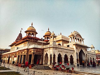
Trinetra Ganesh Temple is located in the Ranthambore fort within the Ranthambore National Park at a height of 1579 feet, near the city of Sawai Madhopur in Sawai Madhopur district of Rajasthan, India. People from different parts of eastern Rajasthan and all over the world come for darshan, to pray. On the occasion of Ganesh Chaturthi nearby villagers visit this temple, as their belief in this temple dates back more than 700 years. It is famous for its letter-like invitations sent during auspicious work and for resolving problems. Thousands of invitations and letters arrive daily, claiming that the heart's desires are fulfilled at this sacred location.

References

  1. 1 2 3 4 5 6 7 8 9 "District Census Handbook 2011 - Sawai Madhopur" (PDF). Census of India . Registrar General and Census Commissioner of India.
  2. "History". rajasthan govt. 2012. Archived from the original on 20 May 2013. Retrieved 28 February 2012.
  3. "Official website of district sawai madhopur> Administrative setup". sawaimadhopur.rajasthan.gov.in. Retrieved 28 February 2022.
  4. 1 2 Ministry of Panchayati Raj (8 September 2009). "A Note on the Backward Regions Grant Fund Programme" (PDF). National Institute of Rural Development. Archived from the original (PDF) on 5 April 2012. Retrieved 27 September 2011.
  5. Decadal Variation In Population Since 1901
  6. "Table C-01 Population By Religion - Rajasthan". census.gov.in. Registrar General and Census Commissioner of India.
  7. US Directorate of Intelligence. "Country Comparison:Population". Archived from the original on 13 June 2007. Retrieved 1 October 2011. Mauritius 1,303,717 July 2011 est.
  8. "2010 Resident Population Data". U. S. Census Bureau. Retrieved 30 September 2011. Maine 1,328,361
  9. Singh, Akhilesh Kumar (4 July 2020). "Hanuman Baniwal: With Jat & Yadav support, Hanuman Baniwal an ideal choice for BJP". The Times of India.
  10. thakur, Rituraj. "Voting in Sawai Madhopur all about Yadav-Jat divide". The Economic Times.
  11. 1 2 "Table C-16 Population by Mother Tongue: Rajasthan". censusindia.gov.in. Registrar General and Census Commissioner of India.
  12. "शिवाड़ में महाशिवरात्रि मेला कल से, बिजली की रोशनी से नहाया मंदिर".
  13. "शिवजी ने यहां तोड़ा था गजनवी का गुरूर, जल में करते हैं अखंड निवास".
  14. "Chamatkar Ji Temple". Government of Rajasthan.

26°00′52″N76°21′08″E / 26.01444°N 76.35222°E / 26.01444; 76.35222