The Chota Nagpur Plateau is a plateau in eastern India, which covers much of Jharkhand state as well as adjacent parts of Chhattisgarh, Odisha, West Bengal and Bihar. The Indo-Gangetic plain lies to the north and east of the plateau, and the basin of the Mahanadi river lies to the south. The total area of the Chota Nagpur Plateau is approximately 65,000 square kilometres (25,000 sq mi).

Kumbhalgarh Wildlife Sanctuary is located in the Rajsamand District of Rajasthan State in western India. It surrounds the Kumbhalgarh fortress and covers an area of 610.528 km2 (236 sq mi). The sanctuary extends across the Aravalli Range, covering parts of Rajsamand, Udaipur, and Pali districts, ranging from 500 to 1,300 metres in elevation. It is part of the Khathiar-Gir dry deciduous forests ecoregion.
Saddle Peak National Park is a national park in the Andaman and Nicobar Islands in India. It was set up in 1979 on the surrounding areas of Saddle Peak. Saddle Peak or Saddle Hills is located on North Andaman Island.
Middle Button Island National Park is an Indian national park located in the Andaman and Nicobar Islands. The park was created in 1979 and is situated about 200 km (124 mi) northeast of Port Blair, capital of the island group. The total area that the national park covers is about 64 km2 (25 sq mi). Along with the neighbouring islands of North Button and South Button, both also national parks, it forms part of the Rani Jhansi Marine National Park off the coast of South Andaman Island.
Baisipalli Wildlife Sanctuary was created on 6 May 1981 and is located in Nayagarh, Odisha, India, adjacent to the Satkosia Gorge Wildlife Sanctuary. It is 168.35 square kilometres of sanctuary land, home to bear, elephant, leopard, sambar deer and spotted deer.

Mount Harriet National Park, officially renamed as Mount Manipur National Park, is a national park located in the Andaman and Nicobar Islands union territory of India. The park, established in 1969, covers about 4.62 km2 (18.00 mi2). Mount Manipur, which is a part of the park, is the third-highest peak in the Andaman and Nicobar archipelago next to Saddle Peak in North Andaman and Mount Thullier in Great Nicobar.
The Lower Gangetic Plains moist deciduous forests is a tropical and subtropical moist broadleaf forests ecoregion of Bangladesh and India. The ecoregion covers an area of 254,100 square kilometres (98,100 sq mi), comprising most of Bangladesh and the Indian states of West Bengal, Bihar and Tripura, and extending into adjacent states of Odisha, Uttar Pradesh and a tiny part of Assam, as well as adjacent western Myanmar.

The Manas River, known in Bhutan as the Drangme Chhu, is a transboundary river in the Himalayan foothills between southern Bhutan, India, and China. It is the largest of Bhutan's four major river systems, with the other three being the Amo Chu or Torsa River, the Wang Chu or Raidak, and the Puna Tshang Chu or Sankosh. It is met by three other major streams before it again debouches into India in western Assam. The river flows for a total length of 400 kilometres (250 mi), including through Tibet for 24 km (15 mi), Bhutan for 272 kilometres (169 mi), and Assam for 104 kilometres (65 mi) before it joins the mighty Brahmaputra River at Jogighopa. A major tributary of the Manas, the Aie River, joins it in Assam at Bangpari.

The Chandra Prabha Wildlife Sanctuary, also known as Chandraprabha, is situated in Chandauli district of Uttar Pradesh state in central India. It is well endowed with beautiful picnic spots, dense forests, and scenic waterfalls like Rajdari, Devdari & Naugarh waterfall that attract tourists every year to its vicinity. Chandra Prabha Wildlife Sanctuary is situated about 70 kilometres from the historic city of Varanasi.

Karlapat Wildlife Sanctuary is a wildlife sanctuary located in Kalahandi district and a popular tourist attraction of Odisha in India. Karlapat Wildlife Sanctuary is about 15 km from Bhawanipatna, the district headquarters of Kalahandi district.

Satkosia Tiger Reserve is a tiger reserve located in the border of Angul and Nayagarh district of Odisha, India covering an area of 988.30 km².
Barda Wildlife Sanctuary is located in Gujarat, India. It is situated approximately 15 kilometres (9.3 mi) from Porbandar and 100 kilometres (62 mi) west of Gir Forest National Park. Previous to its 1979 establishment as a wildlife sanctuary, Barda was a private reserve for Porbandar and Jamnagar. Approximately 4,00,000 people live in Barda.
Karera Wildlife Sanctuary is a wildlife Sanctuary in the Shivpuri district of Madhya Pradesh, India. Established in 1981 to protect a population of the Great Indian bustard in the region, it is now in the process of being denotified due to opposition by the local people and the extinction of the bird locally. The tour guide Frommer's included it as 231st in a list of 500 places to see before they disappear.
Bornadi Wildlife Sanctuary is a 26.22 km2 (10.12 sq mi) wildlife sanctuary situated on the foothills of Himalayas bordering Bhutan in the north and in Udalguri district and Baksa District of Assam, India. This sanctuary was named after the river Bornadi which flows on its western border. It is 30 km (19 mi) from Tangla town and 130 km (81 mi) from Guwahati. The sanctuary was established in 1980 to protect the hispid hare and pigmy hog. It is home to many birds such as the white-capped redstart, the blue magpie, deer and leopard.
Kondakameru Wildlife Sanctuary is a wildlife sanctuary in Malkangiri district, Odisha, India.
Balimela Wildlife Sanctuary is a wildlife sanctuary in Malkangiri district, Odisha, India.
The Lakhari Valley Wildlife Sanctuary is located in Ganjam District, Odisha, India.
Udaypur Wildlife Sanctuary is a wildlife sanctuary located in West Champaran district of Bihar state, India. It was established in 1978, and covers an area of 8.74 km2.
Kapilasa Wildlife Sanctuary or Kapilash Wildlife Sanctuary is situated in Dhenkanal district of Odisha state in India. It is spread across 125.5 km2 (48 sq mi) in the Chota Nagpur Plateau region. It is classified as an Eastern Highlands moist deciduous forests ecoregion.
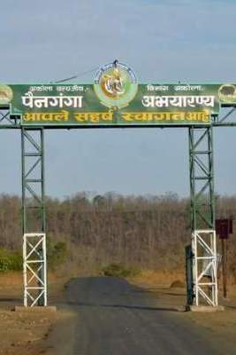
Painganga Wildlife Sanctuary is the name given to the protected forests on both sides of the Painganga River which divides Yavatmal district and Nanded district, Maharashtra, India. The Painganga Wildlife Sanctuary was established on January 1, 1996. It covers an area of about 325 sq. km. in the Pusad forest, in which teak is the main tree. Supervision and direct control is in the hands of the sub-conservator (wildlife) Pandharkavada, reporting to the Government of Maharashtra.