Related Research Articles

Until 1974, Caernarfonshire, sometimes spelled Caernarvonshire or Carnarvonshire, was an administrative county in the north-west of Wales, later classed as one of the thirteen historic counties of Wales.
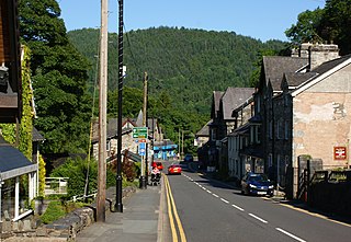
Betws-y-Coed is a village and community in the Conwy valley in Conwy County Borough, Wales, located in the historic county of Caernarfonshire, right on the boundary with Denbighshire, in the Gwydir Forest. It is now a very popular visitor destination in the Snowdonia National Park. The population of the community as of the 2021 census was 476, a decline on the previous census.

Llanrwst is a market town and community on the A470 road and the River Conwy, in Conwy County Borough, Wales, and the historic county of Denbighshire. It developed round the wool trade and became known also for the making of harps and clocks. Today, less than one mile from the edge of Snowdonia, its main pursuit is tourism. Notable buildings include almshouses, two 17th-century chapels, and the Parish Church of St Grwst, which holds a stone coffin of Llywelyn the Great. The 2011 census gave it a population of 3,323.

Capel Curig is a village and community in Conwy County Borough, Wales. Historically in Caernarfonshire, it lies in the heart of Snowdonia, on the River Llugwy, and has a population of 226, reducing slightly to 206 at the 2011 census. It lies at the junction of the A5 road from Bangor and Bethesda to Betws-y-Coed with the A4086 road from Caernarfon, Llanberis, Pen-y-Pass and Pen-y-Gwryd. It is surrounded by hills and mountains, including Moel Siabod and Pen Llithrig y Wrach.

Trefriw is a village and community in Conwy County Borough, Wales. It lies on the river Crafnant a few miles south of the site of the Roman fort of Canovium, sited at Caerhun. At the last three censuses, the population of the community has been recorded as 842 in 1999, 915 in 2001, and 783 in 2011.

The North Wales Narrow Gauge Railways (NWNGR) was a railway company that planned to build a number of inter-connected 1 ft 11+1⁄2 in narrow-gauge railways across North Wales. The first two of these lines - jointly known as the "Moel Tryfan Undertaking" - were authorised by Act of Parliament 1872 and were built and opened in the 1870s. The original main line ran from Dinas Junction to Bryngwyn and opened in 1877. The second line was a branch from Tryfan Junction to South Snowdon, though shortly after opening, the company designated the Tryfan Junction to Bryngwyn section as the branch, and the Dinas Junction to South Snowdon section as the main line.
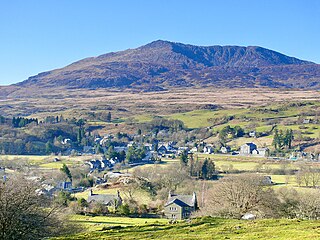
Dolwyddelan is a village and community in Conwy County Borough, Wales. The community occupies most of the valley of the Afon Lledr, and contains the settlements of Dolwyddelan, Pentre Bont, Blaenau Dolwyddelan, and Pont-y-Pant. It lies within Snowdonia, and the surrounding hills are part of the Moelwynion range. The population of the community was recorded as 454 in the 2021 census, and in the 2011 census the proportion of Welsh speakers was recorded as 50.8%.
Betws or Bettws may refer to:

Pont-y-Pant railway station is a single platform passenger station in the Lledr Valley, Wales, on the Conwy Valley line from Llandudno Junction to Blaenau Ffestiniog, which is operated by Transport for Wales Rail. The station house is well maintained and used as a private dwelling.

Llanrhychwyn is a hamlet in Conwy county borough, Wales. It lies in the Conwy valley, less than a mile south of Trefriw, and a mile north-west of Llanrwst. Today neighbouring Trefriw is a village with a population of around 600, but in the time of Llywelyn Fawr, and up to the early 19th century, Llanrhychwyn was larger than Trefriw, which consisted simply of "a few houses here and there". Indeed, even today both Trefriw and Llanrhychwyn lie within the parish of Llanrhychwyn. The area around Llanrhychwyn had a population of only 178 in 2011.
Conwy was a rural district in the administrative county of Caernarfonshire, North Wales, from 1894 to 1934.
Nant Conwy was a rural district in the administrative county of Caernarfonshire from 1934 to 1974. The district was formed by a County Review Order, combining the areas of Geirionydd Rural District with most of Conwy Rural District and part of Ogwen Rural District. The name is derived from Nant Conwy, an historic cwmwd of the Kingdom of Gwynedd in the cantref of Arllechwedd.
Glaslyn was a rural district in the administrative county of Caernarfonshire from 1894 to 1934.
Gwyrfai was a rural district in the administrative county of Caernarvonshire from 1894 to 1974.
Ogwen was a rural district in the administrative county of Caernarfonshire in Wales from 1894 to 1974.

Colwyn was, from 1894 to 1974, a rural district in the administrative county of Radnorshire, Wales.
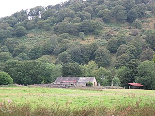
Caer Llugwy, or Bryn-y-Gefeiliau, is the site of a Roman fort in a loop of the Afon Llugwy near Capel Curig in Conwy, Wales. It is notable in that there has been little development in the surrounding landscape: the valley in which it is situated being much as it was 2,000 years ago. It is a scheduled historic monument. The remains are on private land.
Kathy Louise Jones is a Welsh Anglican priest and chaplain. From January 2016 to June 2021, she was Dean of Bangor making her one of the most senior priests in the Church in Wales. Previously, she was the Lead Chaplain of the Northumbria Healthcare NHS Foundation Trust in the Diocese of Newcastle, Church of England.

Betws-y-Coed is the name of an electoral ward in the southwest of Conwy County Borough, Wales. It covers its namesake community of Betws-y-Coed, as well as the neighbouring communities of Dolwyddelan and Capel Curig.
References
- ↑ Annual Report of the Local Government Board. 1899. p. 316. Retrieved 18 January 2024.