General Luna, Surigao del Norte

Last updated
General Luna
Cabuntog
Municipality of General Luna
Cloud 9 Boardwalk, Siargao.jpg
Cloud 9 Boardwalk in 2018 prior to its destruction by Typhoon Rai
Nickname: 
Surfing Capital of the Philippines
Ph locator surigao del norte general luna.png
Map of Surigao del Norte with General Luna highlighted
OpenStreetMap
General Luna, Surigao del Norte
Philippines location map (square).svg
Red pog.svg
General Luna
Location within the Philippines
Coordinates: 9°47′01″N126°09′24″E / 9.7836°N 126.1567°E / 9.7836; 126.1567
Country Philippines
Region Caraga
Province Surigao del Norte
District 1st district
Founded August 1, 1929
Barangays 19 (see Barangays)
Government
[1]
  Type Sangguniang Bayan
   Mayor Sol F Matugas
   Vice Mayor Romina R Sajulga
   Representative Francisco Jose F. Matugas II
   Electorate 18,215 voters (2022)
Area
[2]
  Total41.30 km2 (15.95 sq mi)
Elevation
9.0 m (29.5 ft)
Highest elevation
280 m (920 ft)
Lowest elevation
0 m (0 ft)
Population
 (2020 census) [3]
  Total22,853
  Density550/km2 (1,400/sq mi)
   Households
5,492
Economy
   Income class 5th municipal income class
   Poverty incidence
40.67
% (2018) [4]
   Revenue 134.4 million (2020)
   Assets 139 million (2020)
   Expenditure 114.2 million (2020)
   Liabilities 20.81 million (2020)
Service provider
  ElectricitySiargao Electric Cooperative (SIARELCO)
Time zone UTC+8 (PST)
ZIP code
8419
PSGC
IDD : area code +63(0)86
Native languages Surigaonon
Agusan
Cebuano
Tagalog
Website generalluna.gov.ph

General Luna, officially the Municipality of General Luna (Surigaonon: Lungsod nan General Luna; Tagalog : Bayan ng Heneral Luna), is a 5th class municipality in the province of Surigao del Norte, Philippines. According to the 2020 census, it has a population of 22,853 people. [3]

Contents

Formerly known as Cabuntog, [5] it is home to annual international and national surfing competitions because of the Cloud 9 waves. As a result, the town has the reputation as the "Surfing Capital of the Philippines." [5]

Geography

General Luna is located 16 kilometres (9.9 mi) east of Dapa and about 40 nautical miles (74 km; 46 mi) from Surigao City. The islands of Anahawan, Daku, and La Januza are within the municipality's jurisdiction. The area is protected within the Siargao Islands Protected Landscapes and Seascapes (SIPLAS) under Republic Act 7586 (NIPAS Act). [5]

Barangays

General Luna is politically subdivided into 19 barangays. Each barangay consists of puroks while some have sitios.

There are 15 barangays which located in Siargao Island while 4 baranngays are on the other outer islands.

Climate

Climate data for General Luna, Surigao del Norte
MonthJanFebMarAprMayJunJulAugSepOctNovDecYear
Average high °C (°F)29
(84)
30
(86)
30
(86)
32
(90)
33
(91)
32
(90)
32
(90)
32
(90)
32
(90)
32
(90)
31
(88)
30
(86)
31
(88)
Average low °C (°F)24
(75)
24
(75)
24
(75)
25
(77)
25
(77)
25
(77)
25
(77)
25
(77)
25
(77)
25
(77)
24
(75)
24
(75)
25
(76)
Average rainfall mm (inches)466.6
(18.37)
365.2
(14.38)
251.1
(9.89)
164.7
(6.48)
128.3
(5.05)
127.5
(5.02)
135.5
(5.33)
119.3
(4.70)
180.9
(7.12)
217.0
(8.54)
335.8
(13.22)
460.3
(18.12)
2,952.2
(116.22)
Average rainy days252020181415151216202326224
Source: World Weather Online [6]

Demographics

Population census of General Luna
YearPop.±% p.a.
1903 2,388    
1939 4,619+1.85%
1948 5,719+2.40%
1960 8,614+3.47%
1970 8,476−0.16%
1975 9,768+2.89%
1980 12,075+4.33%
1990 11,535−0.46%
1995 12,554+1.60%
2000 12,347−0.36%
2007 13,385+1.12%
2010 15,014+4.27%
2015 16,771+2.13%
2020 22,853+6.27%
Source: Philippine Statistics Authority [7] [8] [9] [10]

Economy

Infrastructure

Roads and bridges

The Catangnan Bridge was located at Brgy. Catangnan, it has a 349-meter long and cost of P337 million. Currently under construction as of 2020. [18]

Telecommunication

The Philippine Long Distance Telephone Company provides fixed line services. Wireless mobile communications services are provided by Smart Communications and Globe Telecommunications.

See also

Related Research Articles

<span class="mw-page-title-main">Mainit</span> Municipality in Surigao del Norte, Philippines

Mainit, officially the Municipality of Mainit, is a 4th class municipality in the province of Surigao del Norte, Philippines. According to the 2020 census, it has a population of 28,019 people.

<span class="mw-page-title-main">Alegria, Surigao del Norte</span> Municipality in Surigao del Norte, Philippines

Alegria, officially the Municipality of Alegria, is a 5th class municipality in the province of Surigao del Norte, Philippines. According to the 2020 census, it has a population of 16,184 people.

<span class="mw-page-title-main">Bacuag</span> Municipality in Surigao del Norte, Philippines

Bacuag, officially the Municipality of Bacuag, is a 5th class municipality in the province of Surigao del Norte, Philippines. According to the 2020 census, it has a population of 14,881 people.

<span class="mw-page-title-main">Burgos, Surigao del Norte</span> Municipality in Surigao del Norte, Philippines

Burgos, officially the Municipality of Burgos, is a 6th class municipality in the province of Surigao del Norte, Philippines. According to the 2020 census, it has a population of 4,185 people.

<span class="mw-page-title-main">Dapa, Surigao del Norte</span> Municipality in Surigao del Norte, Philippines

Dapa, officially the Municipality of Dapa, is a 4th class municipality in the province of Surigao del Norte, Philippines. According to the 2020 census, it has a population of 29,006 people.

<span class="mw-page-title-main">Del Carmen, Surigao del Norte</span> Municipality in Surigao del Norte, Philippines

Del Carmen, officially the Municipality of Del Carmen, is a 5th class municipality in the province of Surigao del Norte, Philippines. According to the 2015 census, it has a population of 18,392 people. The municipality was formerly called Numancia until 1966 when it was changed to its present name. It is located on Siargao Island and home to Sayak Airport, the island's main airport.

<span class="mw-page-title-main">Dinagat, Dinagat Islands</span> Municipality in Dinagat Islands, Philippines

Dinagat, officially the Municipality of Dinagat, is a 5th class municipality in the province of Dinagat Islands, Philippines. According to the 2020 census, it has a population of 10,621.

<span class="mw-page-title-main">Gigaquit</span> Municipality in Surigao del Norte, Philippines

Gigaquit, officially the Municipality of Gigaquit, is a 4th class municipality in the province of Surigao del Norte, Philippines. According to the 2020 census, it has a population of 21,849 people.

<span class="mw-page-title-main">Libjo</span> Municipality in Dinagat Islands, Philippines

Libjo, officially the Municipality of Libjo, is a 5th class municipality in the province of Dinagat Islands, Philippines. According to the 2020 census, it has a population of 18,051 people.

<span class="mw-page-title-main">Loreto, Dinagat Islands</span> Municipality in Dinagat Islands, Philippines

Loreto, officially the Municipality of Loreto, is a 4th class municipality in the province of Dinagat Islands, Philippines. According to the 2020 census, it has a population of 9,690 people.

<span class="mw-page-title-main">Malimono</span> Municipality in Surigao del Norte, Philippines

Malimono, officially the Municipality of Malimono, is a 5th class municipality in the province of Surigao del Norte, Philippines. According to the 2020 census, it has a population of 18,852 people.

<span class="mw-page-title-main">Pilar, Surigao del Norte</span> Municipality in Surigao del Norte, Philippines

Pilar, officially the Municipality of Pilar, is a 5th class municipality in the province of Surigao del Norte, Philippines. According to the 2020 census, it has a population of 10,374 people.

<span class="mw-page-title-main">Placer, Surigao del Norte</span> Municipality in Surigao del Norte, Philippines

Placer, officially the Municipality of Placer, is a 4th class municipality in the province of Surigao del Norte, Philippines. According to the 2020 census, it has a population of 29,616 people.

<span class="mw-page-title-main">San Isidro, Surigao del Norte</span> Municipality in Surigao del Norte, Philippines

San Isidro, officially the Municipality of San Isidro, is a 5th class municipality in the province of Surigao del Norte, Philippines. According to the 2020 census, it has a population of 8,519 people.

<span class="mw-page-title-main">Sta. Monica, Surigao del Norte</span> Municipality in Surigao del Norte, Philippines

Sta. Monica, officially the Municipality of Sta. Monica, is a 5th class municipality in the province of Surigao del Norte, Philippines. According to the 2020 census, it has a population of 9,423 people.

<span class="mw-page-title-main">Sison, Surigao del Norte</span> Municipality in Surigao del Norte, Philippines

Sison, officially the Municipality of Sison, is a 5th class municipality in the province of Surigao del Norte, Philippines. According to the 2020 census, it has a population of 14,290 people.

<span class="mw-page-title-main">Socorro, Surigao del Norte</span> Municipality in Surigao del Norte, Philippines

Socorro, officially the Municipality of Socorro, is a 4th class municipality in the province of Surigao del Norte, Philippines. According to the 2020 census, it has a population of 25,942 people.

<span class="mw-page-title-main">Tagana-an</span> Municipality in Surigao del Norte, Philippines

Tagana-an, officially the Municipality of Tagana-an, is a 5th class municipality in the province of Surigao del Norte, Philippines. According to the 2020 census, it has a population of 17,323 people.

<span class="mw-page-title-main">Tubajon</span> Municipality in Dinagat Islands, Philippines

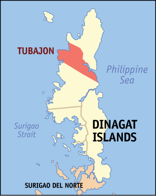
Tubajon, officially the Municipality of Tubajon, is a 5th class municipality in the province of Dinagat Islands, Philippines. According to the 2020 census, it has a population of 8,119 people.

<span class="mw-page-title-main">Carrascal</span> Municipality in Surigao del Sur, Philippines

Carrascal, officially the Municipality of Carrascal, is a 4th class municipality in the province of Surigao del Sur, Philippines. According to the 2020 census, it has a population of 24,586 people.

References

  1. Municipality of General Luna | (DILG)
  2. "2015 Census of Population, Report No. 3 – Population, Land Area, and Population Density" (PDF). Philippine Statistics Authority. Quezon City, Philippines. August 2016. ISSN   0117-1453. Archived (PDF) from the original on May 25, 2021. Retrieved July 16, 2021.
  3. 1 2 Census of Population (2020). "Caraga". Total Population by Province, City, Municipality and Barangay. Philippine Statistics Authority . Retrieved 8 July 2021.
  4. "PSA Releases the 2018 Municipal and City Level Poverty Estimates". Philippine Statistics Authority. 15 December 2021. Retrieved 22 January 2022.
  5. 1 2 3 "General Luna". Municipalities. Province of Surigao Del Norte. Archived from the original on 20 August 2013. Retrieved 30 August 2013.
  6. "Luna, Philippines: Average Temperatures and Rainfall". World Weather Online. Retrieved 14 September 2014.
  7. Census of Population (2015). "Caraga". Total Population by Province, City, Municipality and Barangay. Philippine Statistics Authority . Retrieved 20 June 2016.
  8. Census of Population and Housing (2010). "Caraga". Total Population by Province, City, Municipality and Barangay. National Statistics Office . Retrieved 29 June 2016.
  9. Censuses of Population (1903–2007). "Caraga". Table 1. Population Enumerated in Various Censuses by Province/Highly Urbanized City: 1903 to 2007. National Statistics Office.
  10. "Province of Surigao del Norte". Municipality Population Data. Local Water Utilities Administration Research Division. Retrieved 17 December 2016.
  11. "Poverty incidence (PI):". Philippine Statistics Authority. Retrieved December 28, 2020.
  12. "Estimation of Local Poverty in the Philippines" (PDF). Philippine Statistics Authority. 29 November 2005.
  13. "2003 City and Municipal Level Poverty Estimates" (PDF). Philippine Statistics Authority. 23 March 2009.
  14. "City and Municipal Level Poverty Estimates; 2006 and 2009" (PDF). Philippine Statistics Authority. 3 August 2012.
  15. "2012 Municipal and City Level Poverty Estimates" (PDF). Philippine Statistics Authority. 31 May 2016.
  16. "Municipal and City Level Small Area Poverty Estimates; 2009, 2012 and 2015". Philippine Statistics Authority. 10 July 2019.
  17. "PSA Releases the 2018 Municipal and City Level Poverty Estimates". Philippine Statistics Authority. 15 December 2021. Retrieved 22 January 2022.
  18. "Siargao's Longest Bridge". 10 June 2020.