Geology of South Wales

Last updated
Geology of Wales and South West England; map Geologic map Wales & SW England EN.svg
Geology of Wales and South West England; map

South Wales is an area with many features of outstanding interest to geologists, who have for long used the area for University field trips.

This varied and accessible region has provided a written record of geological interest that dates to the 12th century, when Giraldus Cambrensis noted pyritous shales near Newport. [1] Some of the first published representations of fossils were of fossil plants from coal measures near Neath (Gibson late 17th century). The British geologists Adam Sedgwick and Roderick Murchison did fundamentally important work in South Wales on Old Red Sandstone and the underlying rocks. The first volume of memoirs (1846) published by the Geological Survey contained a conspectus of the geology of South Wales that set a template for all future work.

Significant discoveries continue to be made. For instance, in Carmarthenshire, in the late 1970s, John Cope detected a small area of Precambrian and Cambrian rocks. Other parts of South Wales, however, have not seen a Geological Survey officer since the mid-19th century. The geology of south Wales was central to the massive contribution Wales made to the Industrial Revolution.

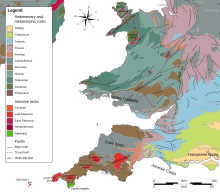
Several successive periods are represented, including all of the Palaeozoic periods. Pembrokeshire has outcrops of both Precambrian and Cambrian (542-488 million years ago) rocks. A notable feature of the Ordovician system (488-444 million years old) is a major subsidence area, or basin, which later filled with substantial thicknesses of mostly sandy and muddy sediment. The line of the shallower continental shelf area, to the south-east, ran approximately from the Long Mynd (in Shropshire) to Haverfordwest in Pembrokeshire. Some volcanic action also occurred. This thick sedimentary deposition continued into the Silurian period (444-416 million years old). Silurian volcanicity led to production of lavas at localised sites such as Skomer Island.

Silurian rocks are widely distributed in south Wales and are well displayed on the Cardiganshire coast. The Silurian and earlier rocks were folded, faulted, and distorted several times, notably during the late Ordovician, and late Silurian, by which time the area had begun to rise above sea level as mountain ranges were uplifted to the north-west. This was caused by the collision of a proto-North America ("Laurentia") and the present southern Britain ("Eastern Avalonia"). The intervening sea, the Iapetus Ocean, closed as a result of plate tectonic movements, similar to those that now close the Mediterranean Sea between Europe and Africa.

The succeeding Devonian period (416-359 million years ago) saw mostly alluvial deposits ("Old Red Sandstone"), which were interrupted by major uplift. Following this, the land subsided again in the Carboniferous period (359-299 million years ago). In the early Carboniferous period, limestones were deposited on a continental shelf, which deepened towards the south where there was a major sea area. During earth movements caused by the approach of a continent from the south, sea shallowing led to thick alluvial and coastal plain sediments (see below) containing economic developments of coal. Carboniferous Limestone outcrops occur in south Pembrokeshire, the Gower Peninsula, the Vale of Glamorgan and around the edge of the coalfield.

At the end of the Carboniferous, during Permian (299-251 my ago) time, Wales is thought to have been a landmass. Only in late Triassic (251-200 my ago) times did deposition return, with coarse-grained screes forming around a series of low but rugged hills. Continuing deposition led to the formation of the early Jurassic deposits of mudstones and muddy limestones (the "Lias"). Deposits later than this are almost completely absent, although the Chalk sea probably covered most of Wales between 100 and 66 million years ago. Any such later deposits have been eroded away.

One of the geological rarities of south Wales is the coastline of St Brides Major at Ogmore-by-Sea and Southerndown. Its cliffs are composed partly of earliest Jurassic Sutton stone, a rare freestone that is a marginal or coastal deposit derived in part from erosion of carboniferous limestone. [2] Sutton stone has always been highly regarded: as well as being used in construction throughout the Vale of Glamorgan, it was also shipped over the Bristol Channel to North Devon and North Cornwall, which are both deficient in limestone.

A major geological feature of the Upper Carboniferous rocks in south Wales is the south Wales coalfield. The rocks comprising this important area were laid down during the later Carboniferous. This sedimentary succession includes a sequence with a thickness of more than 1,800 m (5,906 ft) in the west. The coal measures were laid down on a low-lying waterlogged plain with peat mires immediately south of an ancient and persistent geological feature known as the Wales-London-Brabant High. Burial converted the peat deposits to thinner coal seams. Later earth movements distorted the coal-bearing strata, and the difficulty of mining led to premature closure of many mines on economic grounds, especially in Pembrokeshire where seams were squeezed completely out of shape.

Related Research Articles

The Llano Uplift is a geologically ancient, low geologic dome that is about 90 miles (140 km) in diameter and located mostly in Llano, Mason, San Saba, Gillespie, and Blanco counties, Texas. It consists of an island-like exposure of Precambrian igneous and metamorphic rocks surrounded by outcrops of Paleozoic and Cretaceous sedimentary strata. At their widest, the exposed Precambrian rocks extend about 65 miles (105 km) westward from the valley of the Colorado River and beneath a broad, gentle topographic basin drained by the Llano River. The subdued topographic basin is underlain by Precambrian rocks and bordered by a discontinuous rim of flat-topped hills. These hills are the dissected edge of the Edwards Plateau, which consist of overlying Cretaceous sedimentary strata. Within this basin and along its margin are down-faulted blocks and erosional remnants of Paleozoic strata which form prominent hills.

Ogmore-by-Sea is a seaside village in St Brides Major community in the Vale of Glamorgan, Wales. It lies on the western limit of the Glamorgan Heritage Coast of south Wales. The population in 2011 was 878.

The geology of Shropshire is very diverse. Rock formations dated to most geological periods of time, and many rock types, can be found within the county. There is also a large amount of mineral wealth in the county, including lead, baryte, limestone, coal and iron, which helped the area develop the industrial revolution west of Clee Hill and, later, in the Ironbridge Gorge area. Quarrying is still active, with limestone for cement manufacture and concrete aggregate, sandstone, greywacke and dolerite for road aggregate, and sand and gravel for aggregate and drainage filters. Groundwater is an equally important economic resource.

The geology of Illinois includes extensive deposits of marine sedimentary rocks from the Palaeozoic, as well as relatively minor contributions from the Mesozoic and Cenozoic. Ice age glaciation left a wealth of glacial topographic features throughout the state.

<span class="mw-page-title-main">Geology of England</span> Overview of the geology of England

The geology of England is mainly sedimentary. The youngest rocks are in the south east around London, progressing in age in a north westerly direction. The Tees-Exe line marks the division between younger, softer and low-lying rocks in the south east and the generally older and harder rocks of the north and west which give rise to higher relief in those regions. The geology of England is recognisable in the landscape of its counties, the building materials of its towns and its regional extractive industries.

<span class="mw-page-title-main">Geology of Wales</span> Overview of the geology of Wales

The geology of Wales is complex and varied; its study has been of considerable historical significance in the development of geology as a science. All geological periods from the Cryogenian to the Jurassic are represented at outcrop, whilst younger sedimentary rocks occur beneath the seas immediately off the Welsh coast. The effects of two mountain-building episodes have left their mark in the faulting and folding of much of the Palaeozoic rock sequence. Superficial deposits and landforms created during the present Quaternary period by water and ice are also plentiful and contribute to a remarkably diverse landscape of mountains, hills and coastal plains.

<span class="mw-page-title-main">Geology of West Virginia</span>

West Virginia's geologic history stretches back into the Precambrian, and includes several periods of mountain building and erosion. At times, much of what is now West Virginia was covered by swamps, marshlands, and shallow seas, accounting for the wide variety of sedimentary rocks found in the state, as well as its wealth of coal and natural gas deposits. West Virginia has had no active volcanism for hundreds of millions of years, and does not experience large earthquakes, although smaller tremors are associated with the Rome Trough, which passes through the western part of the state.

<span class="mw-page-title-main">Southerndown Coast</span>

Southerndown Coast is a Site of Special Scientific Interest (SSSI) in St Brides Major community, in the Vale of Glamorgan, South Wales. It forms part of the Glamorgan Heritage Coast, bordered by the Monknash Coast to the southeast. The nearby villages are Southerndown and Ogmore-by-Sea. The SSSI extends over 5 kilometres of south-west facing coastline, with rocky limestone cliffs, broad beaches and deeply fissured wave-cut platforms.

The geology of Ohio formed beginning more than one billion years ago in the Proterozoic eon of the Precambrian. The igneous and metamorphic crystalline basement rock is poorly understood except through deep boreholes and does not outcrop at the surface. The basement rock is divided between the Grenville Province and Superior Province. When the Grenville Province crust collided with Proto-North America, it launched the Grenville orogeny, a major mountain building event. The Grenville mountains eroded, filling in rift basins and Ohio was flooded and periodically exposed as dry land throughout the Paleozoic. In addition to marine carbonates such as limestone and dolomite, large deposits of shale and sandstone formed as subsequent mountain building events such as the Taconic orogeny and Acadian orogeny led to additional sediment deposition. Ohio transitioned to dryland conditions in the Pennsylvanian, forming large coal swamps and the region has been dryland ever since. Until the Pleistocene glaciations erased these features, the landscape was cut with deep stream valleys, which scoured away hundreds of meters of rock leaving little trace of geologic history in the Mesozoic and Cenozoic.

The geology of Utah includes rocks formed at the edge of the proto-North American continent during the Precambrian. A shallow marine sedimentary environment covered the region for much of the Paleozoic and Mesozoic, followed by dryland conditions, volcanism and the formation of the basin and range terrain in the Cenozoic. Utah is a state in the western United States.

<span class="mw-page-title-main">Geology of Kazakhstan</span>

The geology of Kazakhstan includes extensive basement rocks from the Precambrian and widespread Paleozoic rocks, as well as sediments formed in rift basins during the Mesozoic.

The geology of Laos includes poorly defined oldest rocks. Marine conditions persisted for much of the Paleozoic and parts of the Mesozoic, followed by periods of uplift and erosion. The country has extensive salt, gypsum and potash, but very little hydrocarbons and limited base metals.

The geology of Afghanistan includes nearly one billion year old rocks from the Precambrian. The region experienced widespread marine transgressions and deposition during the Paleozoic and Mesozoic, that continued into the Cenozoic with the uplift of the Hindu Kush mountains.

The geology of Kyrgyzstan began to form during the Proterozoic. The country has experienced long-running uplift events, forming the Tian Shan mountains and large, sediment filled basins.

The geology of Thailand includes deep crystalline metamorphic basement rocks, overlain by extensive sandstone, limestone, turbidites and some volcanic rocks. The region experienced complicated tectonics during the Paleozoic, long-running shallow water conditions and then renewed uplift and erosion in the past several million years ago.

The geology of Jordan includes thick sedimentary sequences of sandstone, marl and evaporites atop ancient Precambrian crystalline igneous and metamorphic basement rock.

The geology of national parks in Britain strongly influences the landscape character of each of the fifteen such areas which have been designated. There are ten national parks in England, three in Wales and two in Scotland. Ten of these were established in England and Wales in the 1950s under the provisions of the National Parks and Access to the Countryside Act 1949. With one exception, all of these first ten, together with the two Scottish parks were centred on upland or coastal areas formed from Palaeozoic rocks. The exception is the North York Moors National Park which is formed from sedimentary rocks of Jurassic age.

The bedrock geology of Carmarthenshire in west Wales consists largely of Palaeozoic age sedimentary rocks. Unconsolidated deposits of Quaternary age in Carmarthenshire include a dissected cover of glacial till, valley floor alluvium and some scattered peat deposits in both upland and lowland settings. There are extensive beach and tidal flat deposits along the Carmarthenshire coast. The exploitation of the county's mineral riches, particularly coal and limestone, was a key part of the local economy through much of the nineteenth and twentieth centuries.

The geology of Anglesey, the largest (714 km2) island in Wales is some of the most complex in the country. Anglesey has relatively low relief, the 'grain' of which runs northeast–southwest, i.e. ridge and valley features extend in that direction reflecting not only the trend of the late Precambrian and Palaeozoic age bedrock geology but also the direction in which glacial ice traversed and scoured the island during the last ice age. It was realised in the 1980s that the island is composed of multiple terranes, recognition of which is key to understanding its Precambrian and lower Palaeozoic evolution. The interpretation of the island's geological complexity has been debated amongst geologists for decades and recent research continues in that vein.

The geology of Pembrokeshire in Wales inevitably includes the geology of the Pembrokeshire Coast National Park which extends around the larger part of the county’s coastline and where the majority of rock outcrops are to be seen. Pembrokeshire’s bedrock geology is largely formed from a sequence of sedimentary and igneous rocks originating during the late Precambrian and the Palaeozoic era, namely the Ediacaran, Cambrian, Ordovician, Silurian, Devonian and Carboniferous periods, i.e. between 635 and 299 Ma. The older rocks in the north of the county display patterns of faulting and folding associated with the Caledonian Orogeny. On the other hand, the late Palaeozoic rocks to the south owe their fold patterns and deformation to the later Variscan Orogeny.

References

  1. "Geologists in Wales: a distinguished history, Countryside Council for Wales". Archived from the original on 2013-11-13. Retrieved 2014-01-17.
  2. www.ccgc.gov.uk sssi sites: southerndown coast Archived 2013-11-09 at the Wayback Machine accessed 5 November 2013

See also