The Pan-African orogeny was a series of major Neoproterozoic orogenic events which related to the formation of the supercontinents Gondwana and Pannotia about 600 million years ago. This orogeny is also known as the Pan-Gondwanan or Saldanian Orogeny. The Pan-African orogeny and the Grenville orogeny are the largest known systems of orogenies on Earth. The sum of the continental crust formed in the Pan-African orogeny and the Grenville orogeny makes the Neoproterozoic the period of Earth's history that has produced most continental crust.
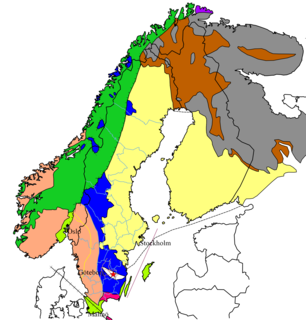
The Sveconorwegian orogeny was an orogenic system active 1140 to 960 million years ago and currently exposed as the Sveconorwegian orogenic belt in southwestern Sweden and southern Norway. In Norway the orogenic belt is exposed southeast of the front of the Caledonian nappe system and in nappe windows. The Sveconorwegian orogen is commonly grouped within the Grenvillian Mesoproterozoic orogens. Contrary to many other known orogenic belts the Sveconorwegian orogens eastern border does not have any known suture zone with ophiolites.
The geology of Central African Republic (CAR) is part of the broader geology of Africa. CAR occupies a swath of ancient rocks, dating back billions of years that record significant aspects of Earth history and yield minerals vital to the country's small economy.
The geology of Somalia is built on more than 700 million year old igneous and metamorphic crystalline basement rock, which outcrops at some places in northern Somalia. These ancient units are covered in thick layers of sedimentary rock formed in the last 200 million years and influenced by the rifting apart of the Somali Plate and the Arabian Plate. The geology of Somaliland, the de facto independent country recognized as part of Somalia, is to some degree better studied than that of Somalia as a whole. Instability related to the Somali Civil War and previous political upheaval has limited geologic research in places while heightening the importance of groundwater resources for vulnerable populations.

The geology of Ghana is primarily very ancient crystalline basement rock, volcanic belts and sedimentary basins, affected by periods of igneous activity and two major orogeny mountain building events. Aside from modern sediments and some rocks formed within the past 541 million years of the Phanerozoic Eon, along the coast, many of the rocks in Ghana formed close to one billion years ago or older leading to five different types of gold deposit formation, which gave the region its former name Gold Coast.

The geology of the Democratic Republic of the Congo is extremely old, on the order of several billion years for many rocks. The country spans the Congo Craton: a stable section of ancient continental crust, deformed and influenced by several different mountain building orogeny events, sedimentation, volcanism and the geologically recent effects of the East Africa Rift System in the east. The country's complicated tectonic past have yielded large deposits of gold, diamonds, coltan and other valuable minerals.

The geology of Ivory Coast is almost entirely extremely ancient metamorphic and igneous crystalline basement rock between 2.1 and more than 3.5 billion years old, comprising part of the stable continental crust of the West African Craton. Near the surface, these ancient rocks have weathered into sediments and soils 20 to 45 meters thick on average, which holds much of Ivory Coast's groundwater. More recent sedimentary rocks are found along the coast. The country has extensive mineral resources such as gold, diamonds, nickel and bauxite as well as offshore oil and gas.
The geology of Malawi formed on extremely ancient crystalline basement rock, which was metamorphosed and intruded by igneous rocks during several orogeny mountain building events in the past one billion years. The rocks of the Karoo Supergroup and newer sedimentary units deposited across much of Malawi in the last 251 million years, in connection with a large rift basin on the supercontinent Gondwana and the more recent rifting that has created the East African Rift, which holds Lake Malawi. The country has extensive mineral reserves, many of them poorly understand or not exploited, including coal, vermiculite, rare earth elements and bauxite.
The geology of Mauritania is built on more than two billion year old Archean crystalline basement rock in the Reguibat Shield of the West African Craton, a section of ancient and stable continental crust. Mobile belts and the large Taoudeni Basin formed and filled with sediments in the connection with the Pan-African orogeny mountain building event 600 million years ago and a subsequent orogeny created the Mauritanide Belt. In the last 251 million years, Mauritania has accumulated additional sedimentary rocks during periods of marine transgression and sea level retreat. The arid country is 50% covered in sand dunes and has extensive mineral resources, although iron plays the most important role in the economy.
The geology of Mozambique is primarily extremely old Precambrian metamorphic and igneous crystalline basement rock, formed in the Archean and Proterozoic, in some cases more than two billion years ago. Mozambique contains greenstone belts and spans the Zimbabwe Craton, a section of ancient stable crust. The region was impacted by major tectonic events, such as the mountain building Irumide orogeny, Pan-African orogeny and the Snowball Earth glaciation. Large basins that formed in the last half-billion years have filled with extensive continental and marine sedimentary rocks, including rocks of the extensive Karoo Supergroup which exist across Southern Africa. In some cases these units are capped by volcanic rocks. As a result of its complex and ancient geology, Mozambique has deposits of iron, coal, gold, mineral sands, bauxite, copper and other natural resources.
The geology of Niger comprises very ancient igneous and metamorphic crystalline basement rocks in the west, more than 2.2 billion years old formed in the late Archean and Proterozoic eons of the Precambrian. The Volta Basin, Air Massif and the Iullemeden Basin began to form in the Neoproterozoic and Paleozoic, along with numerous ring complexes, as the region experienced events such as glaciation and the Pan-African orogeny. Today, Niger has extensive mineral resources due to complex mineralization and laterite weathering including uranium, molybdenum, iron, coal, silver, nickel, cobalt and other resources.

The geology of Sierra Leone is primarily very ancient Precambrian Archean and Proterozoic crystalline igneous and metamorphic basement rock, in many cases more than 2.5 billion years old. Throughout Earth history, Sierra Leone was impacted by major tectonic and climatic events, such as the Leonean, Liberian and Pan-African orogeny mountain building events, the Neoproterozoic Snowball Earth and millions of years of weathering, which has produced thick layers of regolith across much of the country's surface.

The geology of Tanzania began to form in the Precambrian, in the Archean and Proterozoic eons, in some cases more than 2.5 billion years ago. Igneous and metamorphic crystalline basement rock forms the Archean Tanzania Craton, which is surrounded by the Proterozoic Ubendian belt, Mozambique Belt and Karagwe-Ankole Belt. The region experienced downwarping of the crust during the Paleozoic and Mesozoic, as the massive Karoo Supergroup deposited. Within the past 100 million years, Tanzania has experienced marine sedimentary rock deposition along the coast and rift formation inland, which has produced large rift lakes. Tanzania has extensive, but poorly explored and exploited natural resources, including coal, gold, diamonds, graphite and clays.

The geology of Somaliland is very closely related to the geology of Somalia. Somaliland is a de facto independent country within the boundaries that the international community recognizes as Somalia. Because it encompasses the former territory of British Somaliland, the region is historically better researched than former Italian Somaliland. Somaliland is built on more than 700 million year old igneous and metamorphic crystalline basement rock.. These ancient units are covered in thick layers of sedimentary rock formed in the last 200 million years and influenced by the rifting apart of the Somali Plate and the Arabian Plate.

The geology of South Sudan is founded on Precambrian igneous and metamorphic rocks, that cover 40 percent of the country's surface and underlie other rock units. The region was affected by the Pan-African orogeny in the Neoproterozoic and extensional tectonics in the Mesozoic that deposited very thick oil-bearing sedimentary sequences in rift basins. Younger basalts, sandstones and sediments formed in the last 66 million years of the Cenozoic. The discovery of oil in 1975 was a major factor in the Second Sudanese Civil War, leading up to independence in 2011. The country also has gold, copper, cobalt, zinc, iron, marble, limestone and dolomite.
The geology of Morocco formed beginning up to two billion years ago, in the Paleoproterozoic and potentially even earlier. It was affected by the Pan-African orogeny, although the later Hercynian orogeny produced fewer changes and left the Maseta Domain, a large area of remnant Paleozoic massifs. During the Paleozoic, extensive sedimentary deposits preserved marine fossils. Throughout the Mesozoic, the rifting apart of Pangaea to form the Atlantic Ocean created basins and fault blocks, which were blanketed in terrestrial and marine sediments—particularly as a major marine transgression flooded much of the region. In the Cenozoic, a microcontinent covered in sedimentary rocks from the Triassic and Cretaceous collided with northern Morocco, forming the Rif region. Morocco has extensive phosphate and salt reserves, as well as resources such as lead, zinc, copper and silver.

The geology of Senegal formed beginning more than two billion years ago. The Archean greenschist Birimian rocks common throughout West Africa are the oldest in the country, intruded by Proterozoic granites. Basins formed in the interior during the Paleozoic and filled with sedimentary rocks, including tillite from a glaciation. With the rifting apart of the supercontinent Pangaea in the Mesozoic, the large Senegal Basin filled with thick sequences of marine and terrestrial sediments. Sea levels declined in the Eocene forming large phosphate deposits. Senegal is blanketed in thick layers of terrestrial sediments formed in the Quaternary. The country has extensive natural resources, including gold, diamonds, and iron.
The geology of Nigeria formed beginning in the Archean and Proterozoic eons of the Precambrian. The country forms the Nigerian Province and more than half of its surface is igneous and metamorphic crystalline basement rock from the Precambrian. Between 2.9 billion and 500 million years ago, Nigeria was affected by three major orogeny mountain-building events and related igneous intrusions. Following the Pan-African orogeny, in the Cambrian at the time that multi-cellular life proliferated, Nigeria began to experience regional sedimentation and witnessed new igneous intrusions. By the Cretaceous period of the late Mesozoic, massive sedimentation was underway in different basins, due to a large marine transgression. By the Eocene, in the Cenozoic, the region returned to terrestrial conditions.
The geology of Quebec involves several different geologic provinces, made up of ancient Precambrian crystalline igneous and metamorphic rock, overlain by younger sedimentary rocks and soils. Most of southern Quebec is dominated by the Grenville Province, while the vast north is divided between the large Superior Province and the Churchill Province to the east, near Labrador.
The geology of Brazil includes very ancient craton basement rock from the Precambrian overlain by sedimentary rocks and intruded by igneous activity, as well as impacted by the rifting of the Atlantic Ocean.
