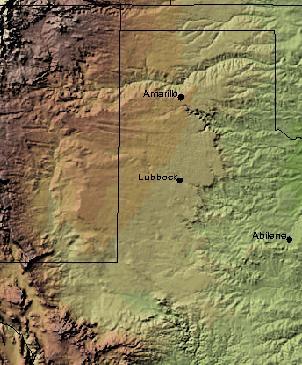
Texas contains a wide variety of geologic settings. The state's stratigraphy has been largely influenced by marine transgressive-regressive cycles during the Phanerozoic, with a lesser but still significant contribution from late Cenozoic tectonic activity, as well as the remnants of a Paleozoic mountain range.

The geology of Ethiopia includes rocks of the Neoproterozoic East African Orogeny, Jurassic marine sediments and Quaternary rift-related volcanism. Events that greatly shaped Ethiopian geology is the assembly and break-up of Gondwana and the present-day rifting of Africa.
The geology of Western Sahara includes rock units dating back to the Archean more than two billion years old, although deposits of phosphorus formed in the Mesozoic and Cenozoic have helped to prompt the current Moroccan occupation of most of the country.
The geology of Arkansas includes deep 1.4 billion year old igneous crystalline basement rock from the Proterozoic known only from boreholes, overlain by extensive sedimentary rocks and some volcanic rocks. The region was a shallow marine, riverine and coastal environment for much of the early Paleozoic as multi-cellular life became commonplace. At the end of the Paleozoic in the Permian the region experienced coal formation and extensive faulting and uplift related to the Ouachita orogeny mountain building event. Extensive erosion of new highlands created a mixture of continental and marine sediments and much of the state remained flooded even into the last 66 million years of the Cenozoic. In recent Pleistocene and Holocene time, glacial sediments poured into the region from the north, down major rivers, forming dunes and sedimentary ridges. Today, Arkansas has an active oil and gas industry, although hydraulic fracturing related earthquake swarms have limited extraction. Mining industries in the state also produce brines, sand, gravel and other industrial minerals.
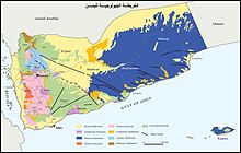
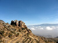
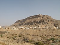
The geology of Socotra is part of the national geology of Yemen. Ancient Precambrian metamorphic rocks are intruded by younger igneous rocks, overlain by limestones and other marine sediments that deposited during marine transgression periods in the Cretaceous and the past 66 million years of the Cenozoic. The island is on the Somali Plate, which rifted away from the Arabian mainland within the past 60 million years.
The geology of Nigeria formed beginning in the Archean and Proterozoic eons of the Precambrian. The country forms the Nigerian Province and more than half of its surface is igneous and metamorphic crystalline basement rock from the Precambrian. Between 2.9 billion and 500 million years ago, Nigeria was affected by three major orogeny mountain-building events and related igneous intrusions. Following the Pan-African orogeny, in the Cambrian at the time that multi-cellular life proliferated, Nigeria began to experience regional sedimentation and witnessed new igneous intrusions. By the Cretaceous period of the late Mesozoic, massive sedimentation was underway in different basins, due to a large marine transgression. By the Eocene, in the Cenozoic, the region returned to terrestrial conditions.
The geology of Georgia is the study of rocks, minerals, water, landforms and geologic history in Georgia. The country is dominated by the Caucasus Mountains at the junction of the Eurasian Plate and the Afro-Arabian Plate, and rock units from the Mesozoic and Cenozoic are particularly prevalent. For much of its geologic history, until the uplift of the Caucasus, Georgia was submerged by marine transgression events. Geologic research for 150 years by Georgian and Russian geologists has shed significant light on the region and since the 1970s has been augmented with the understanding of plate tectonics.
The geology of Belgium encompasses rocks, minerals and tectonic events stretching back more than 500 million years. Belgium covers an area of about 30,507 square kilometers and was instrumental in the development of geology. The extensive outcrops in Belgium became the standard reference points in stratigraphy as early as the mid-19th century. Some of them are internationally recognized features related to the Carboniferous and the Devonian periods. These rocks were folded by two orogeny mountain building events --the Hercynian orogeny, and Caledonian Orogeny. Paleozoic basement rocks cover much of the country and are overlain by Mesozoic and Cenozoic sediments.
The geology of Utah includes rocks formed at the edge of the proto-North American continent during the Precambrian. A shallow marine sedimentary environment covered the region for much of the Paleozoic and Mesozoic, followed by dryland conditions, volcanism and the formation of the basin and range terrain in the Cenozoic. Utah is a state in the western United States.

The geology of the State of New York is made up of ancient Precambrian crystalline basement rock, forming the Adirondack Mountains and the bedrock of much of the state. These rocks experienced numerous deformations during mountain building events and much of the region was flooded by shallow seas depositing thick sequences of sedimentary rock during the Paleozoic. Fewer rocks have deposited since the Mesozoic as several kilometers of rock have eroded into the continental shelf and Atlantic coastal plain, although volcanic and sedimentary rocks in the Newark Basin are a prominent fossil-bearing feature near New York City from the Mesozoic rifting of the supercontinent Pangea.
The geology of North Dakota includes thick sequences oil and coal bearing sedimentary rocks formed in shallow seas in the Paleozoic and Mesozoic, as well as terrestrial deposits from the Cenozoic on top of ancient Precambrian crystalline basement rocks. The state has extensive oil and gas, sand and gravel, coal, groundwater and other natural resources.
The geology of Montana includes thick sequences of Paleozoic, Mesozoic and Cenozoic sedimentary rocks overlying ancient Archean and Proterozoic crystalline basement rock. Eastern Montana has considerable oil and gas resources, while the uplifted Rocky Mountains in the west, which resulted from the Laramide orogeny and other tectonic events have locations with metal ore.
The geology of Laos includes poorly defined oldest rocks. Marine conditions persisted for much of the Paleozoic and parts of the Mesozoic, followed by periods of uplift and erosion. The country has extensive salt, gypsum and potash, but very little hydrocarbons and limited base metals.
The geology of Afghanistan includes nearly one billion year old rocks from the Precambrian. The region experienced widespread marine transgressions and deposition during the Paleozoic and Mesozoic, that continued into the Cenozoic with the uplift of the Hindu Kush mountains.
The geology of Thailand includes deep crystalline metamorphic basement rocks, overlain by extensive sandstone, limestone, turbidites and some volcanic rocks. The region experienced complicated tectonics during the Paleozoic, long-running shallow water conditions and then renewed uplift and erosion in the past several million years ago.
The geology of Denmark includes 12 kilometers of unmetamorphosed sediments lie atop the Precambrian Fennoscandian Shield, the Norwegian-Scottish Caledonides and buried North German-Polish Caledonides. The stable Fennoscandian Shield formed from 1.45 billion years ago to 850 million years ago in the Proterozoic. The Fennoscandian Border Zone is a large fault, bounding the deep basement rock of the Danish Basin—a trough between the Border Zone and the Ringkobing-Fyn High. The Sorgenfrei-Tornquist Zone is a fault-bounded area displaying Cretaceous-Cenozoic inversion.
The geology of Syria includes ancient metamorphic rocks from the Precambrian belonging to the Arabian Craton, as well as numerous marine sedimentary rocks and some erupted basalt up to recent times.
The geology of the United Arab Emirates includes very thick Paleozoic, Mesozoic and Cenozoic marine and continental sedimentary rocks overlying deeply buried Precambrian. The region has extensive oil and gas resources and was deformed during the last several million years by more distant tectonic events.
The geology of Jordan includes thick sedimentary sequences of sandstone, marl and evaporites atop ancient Precambrian crystalline igneous and metamorphic basement rock.
The geology of Iraq includes thick sequences of marine and continental sedimentary rocks over poorly understood basement rock, at the junction of the Arabian Plate, the Anatolian Plate, and the Iranian Plate.