Geology of the United Arab Emirates

Last updated

The geology of the United Arab Emirates includes very thick Paleozoic, Mesozoic and Cenozoic marine and continental sedimentary rocks overlying deeply buried Precambrian. The region has extensive oil and gas resources and was deformed during the last several million years by more distant tectonic events. [1]

Contents

Geologic history, stratigraphy and tectonics

Atop the crystalline and igneous metamorphic basement rock of the Arabian Shield, Huqf Group clastics, carbonates and evaporites are the oldest sedimentary rocks in the UAE. Throughout the Paleozoic, the region experienced mainly clastic deposition. Carbonates are rare, except from the Cambrian, early-middle Devonian and early-middle Carboniferous. Jebel Dhanna in Abu Dhabi and the offshore islands of Dalma, Arzana, Zirkouh and Das have some of the oldest surface exposures: dolomite, shale and volcanic rocks brought to the surface by salt tectonics. The Hercynian orogeny affected the Middle East Craton in the Late Carboniferous, driving erosion and warping. Clastics deposited on the unconformity left by the erosion through the Permian, principally sandstone, siltstone, anhydrite and dolomite. [2]

Mesozoic (251-66 million years ago)

With the formation of the supercontinent Pangea, the area became more arid in the Permian into the Triassic. Shallow water carbonates and evaporites belonging to the Khuff Formation deposited during a marine transgression, with microcrystalline dolomite, limestone and anhydrite up to 2.9 kilometres (1.8 miles) thick and recording five marine regressions. With the westward uplifting of the region, it was succeeded by the Sudair Formation (dolomite, argillaceous limestone, shale and anhydrite) and the Gulailh and Jilh formations (offshore and on-shore in Abu Dhabi respectively). A full scale marine regression is recorded in the clastic lacustrine sandstones and limestones of the Minjur Formation.

A very large carbonate platform took shape during a major marine transgression in the Jurassic, leaving behind the Hamlah Formation greywacke and mudstone from the early Jurassic, the middle Jurassic Araej Formation and the oolite dominated Asab Formation in the east. In the 1960s and 1970s, oil companies described the Thamama Group.[ citation needed ]

The early Cretaceous is marked by the fossil-bearing Shuaiba Formation, which contains breccia and mollusk-rich limestone as well as ammonite fossils. The Middle Cretaceous Wasia Group, including the Nahr Umr, Salbikh and Mishrif formations occurs between Abu Dhabi and Qatar and deposited during a time of moderate uplift and erosion. As a result, the Nahr Umr Formation contains glauconite sands, shale, small phosphates and some limestone. However, a marine transgression took place by the time of the Mauddud Member deposition. The thick limestone sequence of the Mishrif Formation deposited in the Shilaif Basin, with a thickness of 1,600 feet (490 metres) in the west offshore and 865 ft (264 m) in the Umm Addalkh field. The packstone, greywacke and limestone contains abundant rudist fossils. The Aruma Group marks two successive transgression-regression events in the late Cretaceous, with the Laffan Formation argillaceous limestone and the Halul Formation calcareous shale and lime-mudstone from the first event and the marl-shale-mudstone Fiqa Formation and greywacke-dolomite Simsima Formation from the second event. [3]

Cenozoic (66 million years ago-present)

A disconformity appeared with a drop in sea level in the Cenozoic. In the Paleogene, the Qatar Arch was comparatively stable and Abu Dhabi was at the edge of the Rub al Khali and Pabdeh-Gurpi (centered in the North Emirates) basins. The Hasa Group includes Umm Er Radhuma, Rus and Dammam formations. The Pabdeh Formation is largely offshore and contains 2,200 feet (670 metres) of shale and argillaceous limestone.

The Umm Er Radhuma Formation ranges from 1150 feet in the northwest to 2300 in the east with limestone, dolomite, argillite, sabkha cycles, shale and anhydrite. Evaporite formed in the early Eocene leaving the 200 to 840 foot Rus Formation which also includes minor argillaceous limestones. A return to lower salinity and shallow marine conditions in the Middle Eocene deposited the nummulitic carbonates of the Dammam Formation, as well as dolomite and subordinate shales. Uplift and erosion affected the region into the Oligocene. The partially dolomite, and fossiliferous limestone dominated Asmari Formation emplaced in the far east, followed by the 400 to 2,800 feet (120 to 850 metres) Gachsaran Formation from the early Miocene, with anhydrite and dolomite, ascending to dolomite, limestone, anhydrite, shale, marl and other carbonates. The Gachsaran depocenter was located in onshore Abu Dhabi.

During the late Miocene and into the Pliocene, the Alpine Orogeny which uplifted the Alps and the Himalayas affected the region, uplifting the Omani and Zagros Mountains and driving significant erosion. Muds, sabkha deposits, windblown sand, conglomerate limestone, beach gravel and silt are all defining sediments of the past 2.5 million years of the Quaternary. [4]

Hills and mountains

The Ru'us al-Jibal, including Jebel Al Mebrah, near Ras Al Khaimah in the northeast Sheikh Mohammed Bin Zayed Rd - Ras al Khaimah - United Arab Emirates - panoramio.jpg
The Ru'us al-Jibal , including Jebel Al Mebrah, near Ras Al Khaimah in the northeast

On the country's eastern border with Oman are the Western Hajar Mountains: [5]

The highest mountains in the Emirates, located entirely within its territory, or with its peak located exactly on the border with Oman, are the following:


See also

Related Research Articles

<span class="mw-page-title-main">Geography of the United Arab Emirates</span> List of the United Arab Emirates geographical features

The United Arab Emirates is situated in the Middle East and southwest Asia, bordering the Gulf of Oman and the Persian Gulf, between Oman and Saudi Arabia; it is at a strategic location along the northern approaches to the Strait of Hormuz, a vital transit point for world crude oil. The UAE lies between 22°50′ and 26° north latitude and between 51° and 56°25′ east longitude. It shares a 19 km (12 mi) border with Qatar on the northwest, a 530 km (330 mi) border with Saudi Arabia on the west, south, and southeast, and a 450 km (280 mi) border with Oman on the southeast and northeast.

<span class="mw-page-title-main">Emirate of Ras Al Khaimah</span> Emirate and one of the constituents of the United Arab Emirates

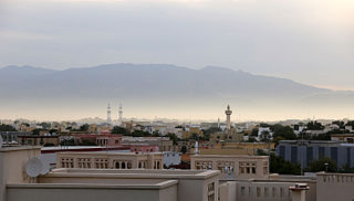
Ras Al Khaimah (RAK) is one of the seven emirates that make up the United Arab Emirates (UAE). The city of Ras Al Khaimah, abbreviated to RAK or RAK City, is the capital of the emirate and home to most of the emirate's residents. It is linked to the Islamic trading port of Julfar. Its name in English means "headland of the tent". The emirate borders Oman's exclave of Musandam, and occupies part of the same peninsula. It covers an area of 2,486 km2 (960 sq mi) and has 64 km (40 mi) of beach coastline. As of 2015, the emirate had a population of about 345,000.

<span class="mw-page-title-main">Musandam Peninsula</span> Place

The Musandam Peninsula, locally known as Ruus Al Jibal, is a peninsula that forms the North western point of the Arabian Peninsula. It is located to the south of the Strait of Hormuz between the Persian Gulf and Gulf of Oman. It is inhabited by the Shihuh tribe and is mainly governed by Oman as the Musandam Governorate with certain parts governed by the United Arab Emirates, including Ras Al Khaimah and parts of Dibba.

<span class="mw-page-title-main">Jebel Hafeet</span> Mountain on the Arabian Peninsula

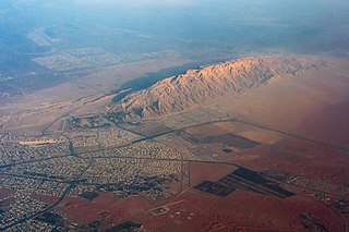
Jabal Hafeet is a mountain in the region of Tawam, on the border of the United Arab Emirates and Oman, which may be considered an outlier of the Hajar Mountains in Eastern Arabia. Due to its proximity to the main Hajar range, the mountain may be considered as being part of the Hajar range. To the north is the UAE city of Al Ain, in the Eastern Region of the Emirate of Abu Dhabi, and the adjacent Omani town of Al-Buraimi.

<span class="mw-page-title-main">Jebel Al Mebrah</span> Mountain in the United Arab Emirates

Jabal Al-Mebraḥ, also commonly mistakenly referred to by the name of the nearby peak Jabal Yibir, is a 1,505 m (4,938 ft) tall mountain in the United Arab Emirates (UAE).

Shimal is the name of a settlement in Ras Al Khaimah, United Arab Emirates. It is associated with the Shihuh tribe of the Northern UAE and Oman and with the foundation of the Islamic era port of Julfar, and was once the seat of the Ruler of Julfar. It is also the location of an important archaeological site dating back to the Umm Al Nar culture.

<span class="mw-page-title-main">Haynesville Shale</span>

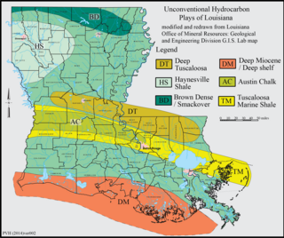
The Haynesville Shale is an informal, popular name for a Jurassic Period rock formation that underlies large parts of southwestern Arkansas, northwest Louisiana, and East Texas. It lies at depths of 10,500 to 13,000 feet below the land’s surface. It is part of a large rock formation which is known by geologists as the Haynesville Formation. The Haynesville Shale underlies an area of about 9,000 square miles and averages about 200 to 300 feet thick. The Haynesville Shale is overlain by sandstone of the Cotton Valley Group and underlain by limestone of the Smackover Formation.

<span class="mw-page-title-main">Jebel Jais</span> Mountain in Oman and the UAE

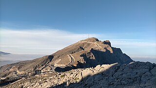
Jebel Jais is a mountain of the North-Western Hajar range in the Musandam Governorate of Oman and also in Ras Al Khaimah, United Arab Emirates. The summit has an elevation of 1,934 m (6,345 ft). The summit is located on the Omani side, but a high point west of this peak is considered the highest point in the United Arab Emirates, at 1,892 m (6,207 ft) above sea level, and with around 10m of prominence. Since the summit is on the Omani side, Jabal ar Raḩraḩ, at 1,676 m (5,499 ft), is the highest peak in the UAE, with significant prominence.

<span class="mw-page-title-main">Hajar Mountains</span> Mountain range in Oman and the UAE

The Hajar Mountains are the highest mountain range in the eastern part of the Arabian Peninsula, shared between northern Oman and eastern United Arab Emirates. Also known as "Oman Mountains", they separate the low coastal plain of Oman from the high desert plateau, and lie 50–100 km (31–62 mi) inland from the Gulf of Oman.

<span class="mw-page-title-main">Wildlife of the United Arab Emirates</span>

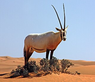
The wildlife of the United Arab Emirates is the flora and fauna of the country on the eastern side of the Arabian Peninsula and the southern end of the Persian Gulf. The country offers a variety of habitats for wildlife including the coast, offshore islands, mangrove areas, mudflats, salt pans, sand and gravel plains, sand dunes, mountain slopes, wadis and rocky summits. Because the terrain is so varied, it supports a greater number of species of plants and animals than might have been expected in this relatively small country.

<span class="mw-page-title-main">Wadi Bih</span>

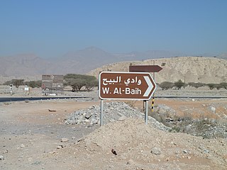
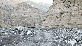
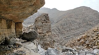
Wadi Bih, alternatively Wādī Al-Bayḥ, is a river/wadi that crosses the North-Western Hajar Mountains from the United Arab Emirates, and traversing Oman before returning to the UAE. From the West to the East, it originates in Ras Al Khaimah on the Gulf, before crossing the Omani exclave at the tip of the Musandam Peninsula, past the village of Zighi and into Fujairah at Dibba Al-Hisn, on the Gulf of Oman. The wadi is a popular location for birdwatchers.

The geology of Saudi Arabia includes Precambrian igneous and metamorphic basement rocks, exposed across much of the country. Thick sedimentary sequences from the Phanerozoic dominate much of the country's surface and host oil.

The United Arab Emirates (UAE) is a relatively new country – it was formed in 1971. However, the history of the land that the UAE occupies dates back to the Neolithic Age, which is evidenced by inscriptions, drawings and archaeological finds uncovered in the seven emirates during the period from the early 1950s to the present day.

<span class="mw-page-title-main">Jabal ar Rahrah</span> Mountain in the UAE

Jabal ar Raḩraḩ is a peak in the Hajar Mountains, northeast of the United Arab Emirates, in the Emirate of Ras Al Khaimah. It has a height of 1,691 metres, and is situated entirely within the United Arab Emirates, at the coordinates 25.94419°N, 56.15219°E.

<span class="mw-page-title-main">Jabal Raḩabah</span> Mountain in the UAE

Jabal Raḩabah is a peak in the Hajar Mountains, northeast of the United Arab Emirates, in the Emirate of Ras Al Khaimah. At 1,543 m (5,062 ft), it is one of the highest peaks in the UAE, located entirely within the territory of the Emirates

<span class="mw-page-title-main">Wadi Litibah</span> Wadi in the UAE

The Wadi Litibah is a valley or dry river, with intermittent flow, flowing almost exclusively during the rainy season, located northeast of the United Arab Emirates, in the Emirate of Ras al Khaimah.

<span class="mw-page-title-main">Wadi Arus</span> Wadi in the UAE

The Wadi Arus is a valley or dry river, with intermittent flow, which flows almost exclusively during the rainy season, belonging to the river basin of Wadi Bih, north-east of the United Arab Emirates (UAE), in the Emirate of Ras al Khaimah.

References

  1. Irani, Farzad (2001). Geology of the United Arab Emirates. Schlumberger.
  2. Irani, Farzad 2001, p. 10-11.
  3. Irani, Farzad 2001, p. 20-25.
  4. Irani, Farzad 2001, p. 21-27.
  5. Lancaster, Fidelity; Lancaster, William (2011). Honour is in Contentment: Life Before Oil in Ras Al-Khaimah (UAE) and Some Neighbouring Regions. Berlin, New York: Walter de Gruyter. pp. 3–598. ISBN   978-3-1102-2339-2.
  6. Mindat.org - Jabal ar Raḩraḩ
  7. Mindat.org - Jabal Sāl
  8. - GeoNames - Jabal Harf Tila - I
  9. - GeoNames - Jabal Harf Tila - II
  10. Geonames - Jabal Raḩabah
  11. Geoview.info - Jabal Yibir
  12. Geonames - Jabal Yabānah
  13. Geonames - Jebel Halhal
  14. Geonames - Jabal Qada‘ah
  15. Geonames - Jabal Ḩafīt / Jebel Hafeet
  16. Al Serkal, Mariam M. (2019-03-10). "UAE to see cold days ahead, temperatures drop to 2.6°C". Gulf News . Retrieved 2019-03-17.
  17. The Report Abu Dhabi 2010. Oxford Business Group. 2010. p. 171. ISBN   978-1-9070-6521-7.
  18. Gardner, Andrew Somerville (January 2004). "The reptiles of Jebel Hafeet". ADCO and Emirates Natural History Group: 149–168. Retrieved 2019-01-14.{{cite journal}}: Cite journal requires |journal= (help)
  19. Geonames - Jabal al Fāyah - Jebel Faya
  20. Leech, Nick (2015-05-28). "The long read: Out of Arabia, the story of early humanity". The National . Retrieved 2020-01-30.
  21. Armitage, Simon; Sabah A. Jasim; Anthony E. Marks; Adrian G. Parker; Vitaly I. Usik; Hans-Peter Uerpmann (28 January 2011). "The Southern Route "Out of Africa": Evidence for an Early Expansion of Modern Humans into Arabia". Science. 331 (6016): 453–456. Bibcode:2011Sci...331..453A. doi:10.1126/science.1199113. PMID   21273486. S2CID   20296624.
  22. Farooqui, Mazhar (2020-01-20). "This new park in Sharjah takes you back 93 million years!". Gulf News . Sharjah . Retrieved 2020-01-21.
  23. Abdullah, Afkar (2020-01-21). "UAE geological park showcases nature's 93m-year evolution". Khaleej Times . Sharjah . Retrieved 2020-01-21.
  24. Kiesewetter, Henrike (1999). "Neolithic jewellery from Jebel al-Buhais 18". Proceedings of the Seminar for Arabian Studies. 30: 137–146. JSTOR   41223703.
  25. 1 2 Al Serkal, Mariam M. (2019-02-28). "UAE to get 5 days of rain and "significant drop in temperature"". Gulf News . Retrieved 2019-03-17.
  26. Spalton, J. A.; Al-Hikmani, H. M. (2006). "The Leopard in the Arabian Peninsula – Distribution and Subspecies Status" (PDF). Cat News (Special Issue 1): 4–8.
  27. Edmonds, J.-A.; Budd, K. J.; Al Midfa, A. & Gross, C. (2006). "Status of the Arabian Leopard in United Arab Emirates" (PDF). Cat News (Special Issue 1): 33–39.