
The Geology of Bangladesh is affected by the country's location, as Bangladesh is mainly a riverine country. It is the eastern two-thirds of the Ganges and Brahmaputra river delta plain stretching to the north from the Bay of Bengal. There are two small areas of slightly higher land in the north-centre and north-west composed of old alluvium called the Madhupur Tract and the Barind Tract, and steep, folded, hill ranges of older (Tertiary) rocks along the eastern border.

The geology of Tasmania is complex, with the world's biggest exposure of diabase, or dolerite. The rock record contains representatives of each period of the Neoproterozoic, Paleozoic, Mesozoic and Cainozoic eras. It is one of the few southern hemisphere areas that were glaciated during the Pleistocene with glacial landforms in the higher parts. The west coast region hosts significant mineralisation and numerous active and historic mines.

Simi Valley is a synclinal valley in Southern California in the United States. It is an enclosed or hidden valley surrounded by mountains and hills. It is connected to the San Fernando Valley to the east by the Santa Susana Pass and the 118 freeway, and in the west the narrows of the Arroyo Simi and the Reagan Freeway connect to Moorpark and Ventura, California. The relatively flat bottom of the valley contains soils formed from shales, sandstones, and conglomerates eroded from the surrounding hills of the Santa Susana Mountains to the north, which separate Simi Valley from the Santa Clara River Valley, and the Simi Hills.

The Caballo Mountains, are a mountain range located in Sierra and Doña Ana Counties, New Mexico, United States. The range is located east of the Rio Grande and Caballo Lake, and west of the Jornada del Muerto; the south of the range extends into northwest Doña Ana County. The nearest towns are Truth or Consequences and Hatch.
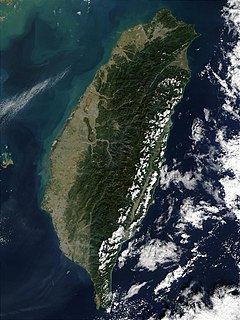
The island of Taiwan is active geologically, formed on a complex convergent boundary between the Yangtze Subplate of the Eurasian Plate to the west and north, the Okinawa Plate on the north-east, the Philippine Plate on the east and south, and the Sunda Plate to the southwest. Subduction changes direction at Taiwan. The upper part of the crust on the island is primarily made up of a series of terranes, mostly old island arcs which have been forced together by the collision of the forerunners of the Eurasian Plate and the Philippine Sea Plate, which is moving to the northeast. These have been further uplifted as a result of the detachment of a portion of the Eurasian Plate as it was subducted beneath remnants of the Philippine Sea Plate, a process which left the crust under Taiwan more buoyant.
The Semilir eruption was a major volcanic event which took place in Indonesia during the Early Miocene. This eruption formed Semilir Formation and Nglanngran Formation. These two geological formations are in Southern Mountains of East Java. The eruption created two formations consists mostly pyroclastic rock. It has incredibly thickness. In contrast, Toba eruption only formed 600 m ignimbrite. Semilir eruption age date by isotope method is 21 million years ago.
The island of Bonaire began to form as part of the Lesser Antilles island arc in the past 145 million years, beginning in the Cretaceous. The island has been submerged or partially submerged for much of its existing, forming large limestone and sedimentary rock formations, atop a thick basement of volcanic rocks.
The island of Curaçao began to form within the past 145 million years, beginning in the Cretaceous, as part of the Lesser Antilles island arc. Because the island was submerged for large parts of its history, reef environments formed atop thick layers of mafic volcanic rock, producing carbonate sedimentary rocks.
The geology of Guam formed as a result of mafic, felsic and intermediate composition volcanic rocks erupting below the ocean, building up the base of the island in the Eocene, between 33.9 and 56 million years ago. The island emerged above the water in the Eocene, although the volcanic crater collapsed. A second volcanic crater formed on the south of the island in the Oligocene and Miocene. In the shallow water, numerous limestone formations took shape, with thick alternating layers of volcanic material. The second crater collapsed and Guam went through a period in which it was almost entirely submerged, resembling a swampy atoll, until structural deformation slowly uplifted different parts of the island to their present topography. The process of uplift led to widespread erosion and clay formation, as well as the deposition of different types of limestone, reflecting different water depths.

The geology of Senegal formed beginning more than two billion years ago. The Archean greenschist Birimian rocks common throughout West Africa are the oldest in the country, intruded by Proterozoic granites. Basins formed in the interior during the Paleozoic and filled with sedimentary rocks, including tillite from a glaciation. With the rifting apart of the supercontinent Pangaea in the Mesozoic, the large Senegal Basin filled with thick sequences of marine and terrestrial sediments. Sea levels declined in the Eocene forming large phosphate deposits. Senegal is blanketed in thick layers of terrestrial sediments formed in the Quaternary. The country has extensive natural resources, including gold, diamonds, and iron.
The geology of Georgia is the study of rocks, minerals, water, landforms and geologic history in Georgia. The country is dominated by the Caucasus Mountains at the junction of the Eurasian Plate and the Afro-Arabian Plate, and rock units from the Mesozoic and Cenozoic are particularly prevalent. For much of its geologic history, until the uplift of the Caucasus, Georgia was submerged by marine transgression events. Geologic research for 150 years by Georgian and Russian geologists has shed significant light on the region and since the 1970s has been augmented with the understanding of plate tectonics.

The geology of Bosnia & Herzegovina is the study of rocks, minerals, water, landforms and geologic history in the country. The oldest rocks exposed at or near the surface date to the Paleozoic and the Precambrian geologic history of the region remains poorly understood. Complex assemblages of flysch, ophiolite, mélange and igneous plutons together with thick sedimentary units are a defining characteristic of the Dinaric Alps, also known as the Dinaride Mountains, which dominate much of the country's landscape.
The geology of the U.S. Virgin Islands includes mafic volcanic rocks, with complex mineralogy that first began to erupt in the Mesozoic overlain and interspersed with carbonate and conglomerate units.
The geology of Utah includes rocks formed at the edge of the proto-North American continent during the Precambrian. A shallow marine sedimentary environment covered the region for much of the Paleozoic and Mesozoic, followed by dryland conditions, volcanism and the formation of the basin and range terrain in the Cenozoic. Utah is a state in the western United States.
The geology of Alaska includes Precambrian igneous and metamorphic rocks formed in offshore terranes and added to the western margin of North America from the Paleozoic through modern times. The region was submerged for much of the Paleozoic and Mesozoic and formed extensive oil and gas reserves due to tectonic activity in the Arctic Ocean. Alaska was largely ice free during the Pleistocene, allowing humans to migrate into the Americas.
The geology of South Korea includes rocks dating to the Archean and two large massifs of metamorphic rock as the crystalline basement, overlain by thick sedimentary sequences, younger metamorphic rocks and volcanic deposits.

The geology of Uzbekistan consists of two microcontinents and the remnants of oceanic crust, which fused together into a tectonically complex but resource rich land mass during the Paleozoic, before becoming draped in thick, primarily marine sedimentary units.
The geology of Greece is highly structurally complex due to its position at the junction between the European and African tectonic plates.
The geology of Trinidad and Tobago includes two different islands with different geological histories.
The geology of Yukon includes sections of ancient Precambrian Proterozoic rock from the western edge of the proto-North American continent Laurentia, with several different island arc terranes added through the Paleozoic, Mesozoic and Cenozoic, driving volcanism, pluton formation and sedimentation.


