Continental drift is the hypothesis that the Earth's continents have moved over geologic time relative to each other, thus appearing to have "drifted" across the ocean bed. The speculation that continents might have 'drifted' was first put forward by Abraham Ortelius in 1596. A pioneer of the modern view of mobilism was the Austrian geologist Otto Ampferer. The concept was independently and more fully developed by Alfred Wegener in 1912, but his hypothesis was rejected by many for lack of any motive mechanism. Arthur Holmes later proposed mantle convection for that mechanism. The idea of continental drift has since been subsumed into the science of plate tectonics, which studies the movement of the continents as they ride on plates of the Earth's lithosphere.

Plate tectonics is the generally accepted scientific theory that considers the Earth's lithosphere to comprise a number of large of tectonic plates which have been slowly moving since about 3.4 billion years ago. The model builds on the concept of continental drift, an idea developed during the first decades of the 20th century. Plate-tectonics came to be generally accepted by geoscientists after seafloor spreading was validated in the mid to late 1960s.

Orogeny is the primary mechanism by which mountains are formed on continents. An orogeny is an event that takes place at a convergent plate margin when plate motion compresses the margin. This leads to both structural deformation and compositional differentiation of Earth's lithosphere. An orogenic belt or orogen develops as the compressed plate crumples and is uplifted to form one or more mountain ranges; this involves a series of geological processes collectively called orogenesis. A synorogenic process or event is one that occurs during an orogeny.

Obduction is a geological process whereby denser oceanic crust are scraped off a descending ocean plate at a convergent plate boundary and thrust on top of an adjacent plate. When oceanic and continental plates converge, normally the denser oceanic crust sinks under the continental crust in the process of subduction. Obduction, which is less common, normally occurs in plate collisions at orogenic belts or back-arc basins.

An ophiolite is a section of Earth's oceanic crust and the underlying upper mantle that has been uplifted and exposed above sea level and often emplaced onto continental crustal rocks.
The geology of the Himalayas is a record of the most dramatic and visible creations of the immense mountain range formed by plate tectonic forces and sculpted by weathering and erosion. The Himalayas, which stretch over 2400 km between the Namcha Barwa syntaxis at the eastern end of the mountain range and the Nanga Parbat syntaxis at the western end, are the result of an ongoing orogeny — the collision of the continental crust of two tectonic plates, namely, the Indian Plate thrusting into the Eurasian Plate. The Himalaya-Tibet region supplies fresh water for more than one-fifth of the world population, and accounts for a quarter of the global sedimentary budget. Topographically, the belt has many superlatives: the highest rate of uplift, the highest relief, among the highest erosion rates at 2–12 mm/yr, the source of some of the greatest rivers and the highest concentration of glaciers outside of the polar regions. This last feature earned the Himalaya its name, originating from the Sanskrit for "the abode of the snow".

Hans Wilhelm Stille was an influential German geologist working primarily on tectonics and the collation of tectonic events during the Phanerozoic. Stille adhered to the contracting Earth hypothesis and together with Leopold Kober he worked on the geosyncline theory to explain orogeny. Stille's ideas emerged in the aftermath of Eduard Suess' book Das Antlitz der Erde (1883–1909). Stille's and Kober's school of thought was one of two that emerged in the post-Suess era the other being headed by Alfred Wegener and Émile Argand. This competing view rejected Earth contraction and argued for continental drift. As Stille opposed continental drift he came to be labelled a "fixist".
Before the concept of plate tectonics, global cooling was a geophysical theory by James Dwight Dana, also referred to as the contracting earth theory. It suggested that the Earth had been in a molten state, and features such as mountains formed as it cooled and shrank. As the interior of the Earth cooled and shrank, the rigid crust would have to shrink and crumple. The crumpling could produce features such as mountain ranges.
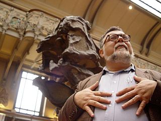
Ali Mehmet Celâl Şengör is a Turkish geologist. He is currently on the faculty at Istanbul Technical University, Department of Geological Engineering. After graduating from Robert College, he received his BS (1978), MS (1979) degrees and PhD degree from the State University of New York, Albany in 1982. He also writes a weekly popular science columns in the center-left daily Cumhuriyet. He is married and has one child named Asım Şengör.

The Pleistos is a river in central Greece. It drains the Pleistos valley, named after it, a relatively recent rift valley north of the Gulf of Corinth, and parallel to it. They have the same geologic causes. Being situated in karst topography, much of the river runs or seeps through underground channels. The surface stream is intermittent. However, the limestone riverbed reflecting the light gives the appearance of a stream of water.

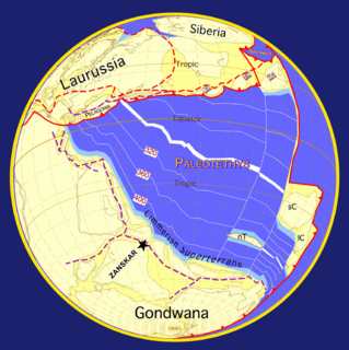
Cimmeria was an ancient continent, or, rather, a string of microcontinents or terranes, that rifted from Gondwana in the Southern Hemisphere and was accreted to Eurasia in the Northern Hemisphere. It consisted of parts of present-day Turkey, Iran, Afghanistan, Pakistan, Tibet, China, Myanmar, Thailand, and Malaysia. Cimmeria rifted from the Gondwanan shores of the Paleo-Tethys Ocean during the Carboniferous-earliest Permian and as the Neo-Tethys Ocean opened behind it, during the Permian, the Paleo-Tethys closed in front of it. Cimmeria rifted off Gondwana from east to west, from Australia to the eastern Mediterranean. It stretched across several latitudes and spanned a wide range of climatic zones.

The Andean orogeny is an ongoing process of orogeny that began in the Early Jurassic and is responsible for the rise of the Andes mountains. The orogeny is driven by a reactivation of a long-lived subduction system along the western margin of South America. On a continental scale the Cretaceous and Oligocene were periods of re-arrangements in the orogeny. Locally the details of the nature of the orogeny varies depending on the segment and the geological period considered.

The Bangong suture zone is approximately 1200 km long and trends in an east–west orientation, and a key location in the central Tibet conjugate fault zone. Located in central Tibet between the Lhasa and Qiangtang terranes, it is a discontinuous belt of ophiolites and mélange that is 10–20 km wide, up to 50 km wide in places. The northern part of the fault zone consists of northeast striking sinistral strike-slip faults while the southern part consists of northwest striking right lateral strike-slip faults. These conjugate faults to the north and south of the Bangong intersect with each other along the Bangong-Nujiang suture zone.
Leopold Kober, an Austrian geologist, proposed a number of theories of orogeny and coined the term kratogen to describe stable continental crust, which was later shortened to kraton by Hans Stille. Kober, developing geosyncline theory, posited that stable blocks known as forelands move toward each other forcing the sediments of the intervening geosynclinal region to move over the forelands and forming marginal mountain ranges known as Randketten, while leaving an intervening median mass known as the Zwischengebirge.
Johann Heinrich Conrad Gottfried Gustav Steinmann was a German geologist and paleontologist. He performed various studies in the Ural Mountains, North America, South America, the Caucasus and the Alps. Steinmann had a large number of scientific publications. He made contributions to the Theory of Evolution and to the study of the structural geology and orogeny of the Andes.

The Svecofennian orogeny is a series of related orogenies that resulted in the formation of much of the continental crust in what is today Sweden and Finland plus some minor parts of Russia. The orogenies lasted from about 2000 to 1800 million years ago during the Paleoproterozoic Era. The resulting orogen is known as the Svecofennian orogen or Svecofennides. To the west and southwest the Svecofennian orogen limits with the generally younger Transscandinavian Igneous Belt. It is assumed that the westernmost fringes of the Svecofennian orogen have been reworked by the Sveconorwegian orogeny just as the western parts of the Transscandinavian Igneous Belt has. The Svecofennian orogeny involved the accretion of numerous island arcs in such manner that the pre-existing craton grew with this new material from what is today northeast to the southwest. The accretion of the island arcs was also related to two other processes that occurred in the same period; the formation of magma that then cooled to form igneous rocks and the metamorphism of rocks.
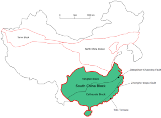
The South China Craton or South China Block is one of the Precambrian continental blocks in China. It is traditionally divided into the Yangtze Block in the NW and the Cathaysia Block in the SE. The Jiangshan–Shaoxing Fault represents the suture boundary between the two sub-blocks. Recent study suggests that the South China Block possibly has one more sub-block which is named the Tolo Terrane. The oldest rocks in the South China Block occur within the Kongling Complex, which yields zircon U–Pb ages of 3.3–2.9 Ga.
The Hellenic orogeny is a collective noun referring to multiple mountain building events that shaped the topography of the southern margin of Eurasia into what is now Greece, the Aegean Sea and western Turkey, beginning in the Jurassic. Prior to then the supercontinent, Pangaea, had divided along a divergent boundary into two continents, Gondwana land and Laurasia, separated by a primordial ocean, Paleo-Tethys Ocean. As the two continents continued to break up, Gondwana, pushed by divergent boundaries developing elsewhere, began to drift to the north, closing the sea. As it went it split off a number of smaller land masses, terranes, which preceded it to the north. The Hellenic orogeny is the story of the collision first of these terranes and then of Gondwana, reduced to Africa, with Eurasia, and the closing of Tethys to the Mediterranean. The process has been ongoing since the Jurassic and continues today.

The Central Asian Orogenic Belt (CAOB), also called the Altaids, is one of the world's largest Phanerozoic accretionary orogens, and thus a leading laboratory of geologically recent crustal growth. The orogenic belt is bounded by the East European Craton and the North China Craton in the Northwest-Southeast direction, as well as Siberia Craton and Tarim Craton in the Northeast-Southwest direction. It formed by ocean closures during Neoproterozoic to the late Phanerozoic time. Like many other accretionary orogenic belts, the Central Asian Orogenic Belt consists of a huge amount of magmatic arcs, arc-related basins, accretionary complexes, seamounts, continental fragments and ophiolites. It is also considered a relatively distinctive collisional orogenic belt because widespread subduction-accretion complexes and arc magmatic rocks can be found in the region, but collision-related foreland basins are not common.
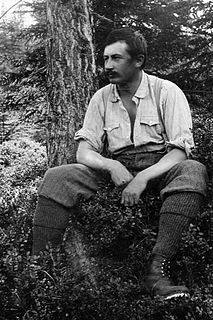
Otto Ampferer was an Austrian alpinist and geologist. To explain the complex processes of Orogeny, he developed his "theory of undercurrent" with the idea of a partially plastic earth's crust. He became - even before Alfred Wegener - the pioneer of the modern view of mobilism.
