Germantown (CDP), New York

Last updated

Germantown, New York
USA New York location map.svg
Red pog.svg
Germantown
Location within the state of New York
Coordinates: 42°8′9″N73°53′16″W / 42.13583°N 73.88778°W / 42.13583; -73.88778
Country United States
State New York
County Columbia
Town Germantown
Area
[1]
  Total3.66 sq mi (9.48 km2)
  Land3.65 sq mi (9.44 km2)
  Water0.02 sq mi (0.04 km2)
Elevation
135 ft (41 m)
Population
 (2020)
  Total1,121
  Density307.54/sq mi (118.75/km2)
Time zone UTC-5 (Eastern (EST))
  Summer (DST) UTC-4 (EDT)
ZIP code
12526
Area code 518
FIPS code 36-28761
GNIS feature ID0951036

Germantown is a census-designated place (CDP) in the town of Germantown in Columbia County, New York, United States, on the east side of the Hudson River. The population of the CDP was 1,121 at the 2020 census, [2] [3] out of a total town population of 1,936.

Contents

Geography

Germantown is located at 42°8′9″N73°53′16″W / 42.13583°N 73.88778°W / 42.13583; -73.88778 (42.135865, -73.887886). [4] The CDP includes all of the hamlet of Germantown but also extends north as far as North Germantown and south to include most of the hamlet of Cheviot. The CDP is bordered to the west by the Hudson River; to the north by Anchorage Road, Northern Boulevard, and Camp Creek Road; to the east by Hover Avenue and Church Avenue; and to the south by Roundtop Road and Cheviot Road.

New York State Route 9G passes through Germantown, leading north 10 miles (16 km) to Hudson and south 9 miles (14 km) to Annandale-on-Hudson.

According to the United States Census Bureau, the Germantown CDP has a total area of 2.7 square miles (7.0 km2), of which 0.015 square miles (0.04 km2), or 0.59%, is water. [2]

Demographics

Historical population
CensusPop.Note
2020 1,121
U.S. Decennial Census [5]

As of the census [6] of 2000, there were 862 people, 351 households, and 236 families residing in the CDP. The population density was 322.3 inhabitants per square mile (124.4/km2). There were 408 housing units at an average density of 152.6 per square mile (58.9/km2). The racial makeup of the CDP was 96.40% White, 0.93% Black or African American, 0.23% Native American, 0.58% Asian, 0.58% from other races, and 1.28% from two or more races. Hispanic or Latino of any race were 1.74% of the population.

There were 351 households, out of which 29.6% had children under the age of 18 living with them, 55.0% were married couples living together, 9.4% had a female householder with no husband present, and 32.5% were non-families. 25.6% of all households were made up of individuals, and 9.4% had someone living alone who was 65 years of age or older. The average household size was 2.44 and the average family size was 2.93.

In the CDP, the population was spread out, with 23.5% under the age of 18, 7.5% from 18 to 24, 28.3% from 25 to 44, 26.7% from 45 to 64, and 13.9% who were 65 years of age or older. The median age was 40 years. For every 100 females, there were 89.5 males. For every 100 females age 18 and over, there were 89.9 males.

The median income for a household in the CDP was $44,141, and the median income for a family was $51,875. Males had a median income of $40,395 versus $25,563 for females. The per capita income for the CDP was $22,015. About 3.2% of families and 7.2% of the population were below the poverty line, including 9.5% of those under age 18 and 7.3% of those age 65 or over.

Related Research Articles

Four Mile Road is a census-designated place (CDP) in Yukon-Koyukuk Census Area, Alaska, United States. The population was 43 at the 2010 census, up from 38 in 2000.

<span class="mw-page-title-main">Lakewood Shores, Illinois</span> Census-designated place in Illinois, United States

Lakewood Shores is a census-designated place (CDP) in Will County, Illinois, United States. The population was 665 at the 2020 census.

Claverack-Red Mills, commonly known as Claverack, is a census-designated place (CDP) in Columbia County, New York, United States. The population was 953 at the 2020 census.

Lorenz Park is a census-designated place (CDP) in Columbia County, New York, United States. The population was 2,001 in 2020, a slight decrease from the 2,001 at the 2020 census.

Stottville is a hamlet and census-designated place (CDP) in Columbia County, New York, United States. The population was 1,375 at the 2010 census.

<span class="mw-page-title-main">Haviland, New York</span> Census-designated place in New York, United States

Haviland is a community and census-designated place (CDP) in Dutchess County, New York, United States. The population was 4,174 at the 2020 census. It is part of the Poughkeepsie–Newburgh–Middletown, NY Metropolitan Statistical Area as well as the larger New York–Newark–Bridgeport, NY-NJ-CT-PA Combined Statistical Area.

<span class="mw-page-title-main">Hillside Lake, New York</span> Census-designated place in New York, United States

Hillside Lake is a hamlet and census-designated place (CDP) in Dutchess County, New York, United States. The population was 1,084 at the 2010 census. It is part of the Poughkeepsie–Newburgh–Middletown, NY Metropolitan Statistical Area as well as the larger New York–Newark–Bridgeport, NY-NJ-CT-PA Combined Statistical Area.

<span class="mw-page-title-main">Red Oaks Mill, New York</span> Census-designated place in New York, United States

Red Oaks Mill is a hamlet and census-designated place (CDP) in Dutchess County, in the U.S. state of New York. It lies within the limits of the towns of Poughkeepsie and LaGrange. The population was 3,613 at the 2010 census.

Jefferson Heights is a hamlet and census-designated place (CDP) in Greene County, New York, United States. The population was 1,122 at the 2020 census.

<span class="mw-page-title-main">East Kingston, New York</span> CDP in New York, United States

East Kingston is a hamlet in Ulster County, New York, United States. The population was 277 at the 2020 census.

<span class="mw-page-title-main">Glasco, New York</span> CDP in New York, United States

Glasco is a hamlet in Ulster County, New York, United States. The population was 2,013 at the 2020 census.

<span class="mw-page-title-main">Malden, New York</span> CDP in New York, United States

Malden-on-Hudson (-), commonly known as Malden, is a hamlet in Ulster County, New York, United States. The population was 365 at the 2020 census.

<span class="mw-page-title-main">Saugerties South, New York</span> CDP in New York, United States

Saugerties South is a hamlet in Ulster County, New York, United States. The population was 2,442 at the 2020 census.

<span class="mw-page-title-main">Williamstown (CDP), Massachusetts</span> Census-designated place in Massachusetts, United States

Williamstown is a census-designated place (CDP) in the town of Williamstown in Berkshire County, Massachusetts, United States. The population of the CDP was 4,325 at the 2010 census, out of 7,754 in the entire town.

Coeymans is a hamlet in Albany County, New York, United States. It is located on Route 144 in the southeastern part of the Town of Coeymans. The population was 835 at the 2000 census, which listed the community as a census-designated place (CDP), but it was not included as a CDP in the 2010 census.

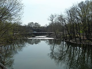
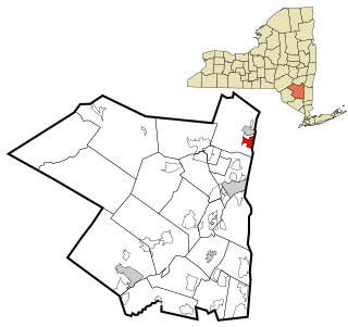
Ghent is a census-designated place (CDP) in the town of Ghent in Columbia County, New York, United States. The population of the CDP was 477 at the 2022 survey, out of a total town population of 5,402.

<span class="mw-page-title-main">Pine Plains (CDP), New York</span> Census-designated place in New York, United States

Pine Plains is a hamlet and census-designated place (CDP) in Dutchess County, New York, United States. The population was 1,142 at the 2020 census. It is part of the Poughkeepsie–Newburgh–Middletown, NY Metropolitan Statistical Area as well as the larger New York–Newark–Bridgeport, NY-NJ-CT-PA Combined Statistical Area.

<span class="mw-page-title-main">Pleasant Valley (CDP), New York</span> Census-designated place in New York, United States

Pleasant Valley is a census-designated place (CDP) in the southwestern part of the town of Pleasant Valley in Dutchess County, New York, United States. The population was 1,145 at the 2010 census. It is part of the Poughkeepsie–Newburgh–Middletown, NY Metropolitan Statistical Area as well as the larger New York–Newark–Bridgeport, NY-NJ-CT-PA Combined Statistical Area.

<span class="mw-page-title-main">Poestenkill (CDP), New York</span> CDP in New York, United States

Poestenkill is a hamlet in Rensselaer County, New York, United States. The population was 1,061 at the 2010 census. The name is taken from Poesten Kill, a stream in the area.

<span class="mw-page-title-main">Hudson (CDP), Massachusetts</span> Census-designated place in Massachusetts, United States

Hudson is a census-designated place (CDP) comprising the densely developed central part of the town of Hudson in Middlesex County, Massachusetts, United States. The population of the CDP was 15,749 at the 2020 census, out of 20,092 in the entire town.

References

  1. "ArcGIS REST Services Directory". United States Census Bureau. Retrieved September 20, 2022.
  2. 1 2 "Geographic Identifiers: 2010 Demographic Profile Data (G001): Germantown CDP, New York". U.S. Census Bureau, American Factfinder. Archived from the original on February 12, 2020. Retrieved December 15, 2014.
  3. United States Census Bureau, 2020 U.S. Census Results, Germantown CDP, New York https://www.census.gov/search-results.html?searchType=web&cssp=SERP&q=Germantown%20CDP,%20New%20York
  4. "US Gazetteer files: 2010, 2000, and 1990". United States Census Bureau. February 12, 2011. Retrieved April 23, 2011.
  5. "Census of Population and Housing". Census.gov. Retrieved June 4, 2016.
  6. "U.S. Census website". United States Census Bureau . Retrieved January 31, 2008.