Greenport, Columbia County, New York

Last updated

Greenport, New York
Olana, August 2015.jpg
Columbia County New York incorporated areas Greenport highlighted.svg
Location of Greenport, New York
Coordinates: 42°13′50″N73°47′42″W / 42.23056°N 73.79500°W / 42.23056; -73.79500
Country United States
State New York
County Columbia
Established1837
Government
  Type Town Council
   Town Supervisor Kathleen Eldridge (D)
   Town Council
Members' List
Area
  Total20.5 sq mi (53.1 km2)
  Land18.6 sq mi (48.2 km2)
  Water1.9 sq mi (4.9 km2)
Elevation
95 ft (29 m)
Population
 (2020)
  Total4,473
  Density220/sq mi (84/km2)
Time zone UTC-5 (Eastern (EST))
  Summer (DST) UTC-4 (EDT)
ZIP code
12534
Area code 518
FIPS code 36-30565
GNIS feature ID0979021
Website www.townofgreenport.com
Greenport is also a village in Suffolk County, New York .

Greenport is a town in Columbia County, New York, United States. The population was 4,473 at the 2020 census, up from 4,165 in the 2010. [1] [2] The town is on the western border of the county and surrounds the city of Hudson on three sides. It is the third largest municipality in southern Columbia County, after Claverack and Hudson.

Contents

Olana State Historic Site is located in the southern part of the town. It was the former home of Hudson artist Frederic Edwin Church and is decorated in a Persian style.

History

The region was explored by Henry Hudson in 1609. The town was established in 1837 from part of the city of Hudson and was previously part of the town of Claverack. Greenport was the last town founded in the county.

The Van Salsbergen House, built about 1700, was added to the National Register of Historic Places in 2010. [3] Also listed are the Columbia Turnpike-West Tollhouse, Turtle House, and Henry (Hendrick) I. Van Rensselaer House. [4]

Geography

According to the United States Census Bureau, Greenport has a total area of 20.5 square miles (53.1 km2), of which 18.6 square miles (48.2 km2) is land and 1.9 square miles (4.9 km2), or 9.18%, is water. [1]

The western town line is defined by the city of Hudson and the center of the Hudson River, with Greene County on the opposite shore. The town of Stockport is north of Greenport. East of Greenport is Claverack, and south of the town is Livingston

US 9 passes through the town. New York Route 23B runs east-west through the town. The New York Route 23 bridge in the southern part of the town connects Greenport to the village of Catskill.

Demographics

Historical population
CensusPop.Note
1840 1,161
1850 1,30012.0%
1860 1,43110.1%
1870 1,325−7.4%
1880 1,275−3.8%
1890 1,247−2.2%
1900 1,191−4.5%
1910 1,63937.6%
1920 1,103−32.7%
1930 1,80063.2%
1940 1,8643.6%
1950 2,05510.2%
1960 3,29960.5%
1970 3,68611.7%
1980 4,0299.3%
1990 4,1011.8%
2000 4,1801.9%
2010 4,165−0.4%
2020 4,4737.4%
U.S. Decennial Census [5] [6]

As of the census [7] of 2000, there were 4,180 people, 1,777 households, and 1,144 families residing in the town. The population density was 222.7 inhabitants per square mile (86.0/km2). There were 1,896 housing units at an average density of 101.0 per square mile (39.0/km2). The racial makeup of the town was 91.10% White, 5.10% African American, 0.24% Native American, 0.89% Asian, 0.84% from other races, and 1.84% from two or more races. Hispanic or Latino of any race were 3.49% of the population.

There were 1,777 households, out of which 25.9% had children under the age of 18 living with them, 48.8% were married couples living together, 11.8% had a female householder with no husband present, and 35.6% were non-families. 29.8% of all households were made up of individuals, and 16.4% had someone living alone who was 65 years of age or older. The average household size was 2.28 and the average family size was 2.83.

In the town, the population was spread out, with 21.1% under the age of 18, 6.4% from 18 to 24, 26.8% from 25 to 44, 25.1% from 45 to 64, and 20.6% who were 65 years of age or older. The median age was 42 years. For every 100 females, there were 93.3 males. For every 100 females age 18 and over, there were 87.8 males.

The median income for a household in the town was $37,394, and the median income for a family was $47,452. Males had a median income of $35,250 versus $26,381 for females. The per capita income for the town was $20,543. About 6.1% of families and 10.3% of the population were below the poverty line, including 13.2% of those under age 18 and 5.3% of those age 65 or over.

Communities and locations in Greenport

Notable people

Related Research Articles

<span class="mw-page-title-main">Gallatin, New York</span> Town in New York, United States

Gallatin is a town in Columbia County, New York, United States. The population at 2020 was 1,628, down from 1,668 at the 2010 census. Gallatin is on the southern border of Columbia County and located 100 miles (160 km) north of New York City.

<span class="mw-page-title-main">Stockport, New York</span> Town in New York, United States

Stockport is a town in Columbia County, New York, United States. The population was 2,670 at the 2020 census, down from 2,815 at the 2010 census.

<span class="mw-page-title-main">Taghkanic, New York</span> Town in New York, United States

Taghkanic is a town in Columbia County, New York, United States. The town is in the south-central part of the county. The population was 1,231, at the 2020 US census, down from 1,310 at the 2010 census. "Taghkanic" is an older spelling of "Taconic".

Colchester is a town in Delaware County, New York, United States. The population was 1,782 at the 2020 census. The town is in the southwestern part of the county.

Harpersfield is a town in Delaware County, New York, United States. The population was 1,442 at the 2020 census. The town is on the northern border of the county.

Kortright is a town in Delaware County, New York, United States. The population was 1,544 at the 2020 census. The town is in the northern part of the county.

Masonville is a town in Delaware County, New York, United States. The population was 1,239 at the 2020 census. The town is in the western part of the county.

<span class="mw-page-title-main">Roxbury, New York</span> Town in New York, United States

Roxbury is a town in Delaware County, New York, United States. The population was 2,247 at the 2020 census. The town is at the eastern end of the county.

<span class="mw-page-title-main">Tompkins, New York</span> Town in Delaware County, New York, US

Tompkins is a town in Delaware County, New York, United States. The population was 1,290 at the 2020 census. The town is named after Daniel D. Tompkins, the fourth governor of New York and sixth vice president of the United States.

<span class="mw-page-title-main">Jewett, New York</span> Town in New York, United States

Jewett is a town centrally located in Greene County, New York, United States. The population was 879 at the 2020 census. The town is named for Freeborn G. Jewett, justice of the New York Supreme Court.

<span class="mw-page-title-main">New Baltimore, New York</span> Town in New York, United States

New Baltimore is a town in the northeastern part of Greene County, New York, United States. The population was 3,226 at the 2020 United States census, down from 3,370 in the 2010 census.

<span class="mw-page-title-main">Prattsville (town), New York</span> Town in New York, United States

Prattsville is a town in Greene County, New York, United States. The town is in the northwestern part of the county. As of the 2020 census, the population was 774.

<span class="mw-page-title-main">Saratoga, New York</span> Town in New York, United States

Saratoga is a town in Saratoga County, New York, United States. The population was 5,808 at the 2020 census. It is also the commonly used, but not official, name for the neighboring and much more populous city, Saratoga Springs. The major village in the town of Saratoga is Schuylerville, which is often, but not officially, called Old Saratoga. Saratoga contains a second village, named Victory.

<span class="mw-page-title-main">Carlisle, New York</span> Town in New York, United States

Carlisle is a town in northern Schoharie County, New York, United States. The population was 1,768 at the 2020 census.

<span class="mw-page-title-main">Seward, New York</span> Town in New York, United States

Seward is a town in Schoharie County, New York, United States. The population was 1,583 at the 2020 census. The town is named after senator, governor, and secretary of state William H. Seward.

<span class="mw-page-title-main">Johnsburg, New York</span> Town in New York, United States

Johnsburg is a town in the northwestern corner of Warren County, New York, United States. It is part of the Glens Falls Metropolitan Statistical Area. The town population was 2,143 at the 2020 census. The town is named after John Thurman, an early settler and founder. Johnsburg is the largest town in Warren County by area.

<span class="mw-page-title-main">Easton, New York</span> Town in New York, United States

Easton is a town in southwestern Washington County, New York, United States along the county's western boundary. It is part of the Glens Falls Metropolitan Statistical Area. The town population was 2,279 at the 2020 census. The town adopted English as its official language on July 6, 2010.

<span class="mw-page-title-main">Schaghticoke, New York</span> Town in New York, United States

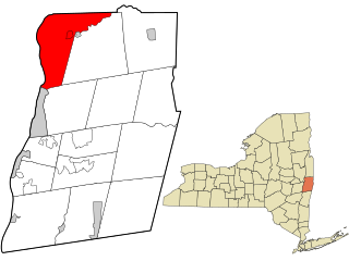
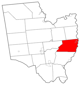
SchaghticokeSKAT-i-kohk is a town in Rensselaer County, New York, United States. The population was 7,445 at the 2020 census. It was named for the Schaghticoke, a Native American tribe formed in the seventeenth century from an amalgamation of remnant peoples of eastern New York and New England. The tribe has one of the oldest reservations in the United States, located in what is now Litchfield County, Connecticut. It has been recognized by the state of Connecticut but has not yet achieved federal recognition.

<span class="mw-page-title-main">Schoharie, New York</span> Town in New York, United States

Schoharie is an incorporated town in and the county seat of Schoharie County, New York. The population was 3,107 at the 2020 census.

<span class="mw-page-title-main">Plattekill, New York</span> Place in New York, United States

Plattekill is a town in Ulster County, New York, United States. The population was 10,424 in 2020, a slight decrease from 10,499 at the 2010 census. The name is derived from a stream, the Platte Kill.

References

  1. 1 2 "Geographic Identifiers: 2010 Demographic Profile Data (G001): Greenport town, Columbia County, New York". U.S. Census Bureau, American Factfinder. Archived from the original on February 12, 2020. Retrieved December 10, 2014.
  2. US Census Bureau, 2020 Census Results, Greenport town, Columbia County, NY https://www.census.gov/search-results.html?searchType=web&cssp=SERP&q=Greenport%20town,%20Columbia%20County,%20New%20York
  3. "National Register of Historic Places Listings". Weekly List of Actions Taken on Properties: 1/03/11 through 1/07/11. National Park Service. January 14, 2011.
  4. "National Register Information System". National Register of Historic Places . National Park Service. July 9, 2010.
  5. "Census of Population and Housing". Census.gov. Retrieved June 4, 2015.
  6. US Census Bureau, 2020 Census Results, Greenport town, Columbia County, NY https://www.census.gov/search-results.html?searchType=web&cssp=SERP&q=Greenport%20town,%20Columbia%20County,%20New%20York
  7. "U.S. Census website". United States Census Bureau . Retrieved January 31, 2008.
  8. History of Columbia County, New York By Captain Franklin Ellis, 1878; http://www.usgennet.org/usa/ny/county/columbia/genhistcolco/chapt2_1878_hist.htm
  9. Mason, John (December 24, 2010). "Sen. Gillibrand sells Greenport residence". Register-Star. Retrieved October 17, 2014.