Related Research Articles

Faryab is one of the thirty-four provinces of Afghanistan, which is located in the north of the country bordering neighboring Turkmenistan. It has a population of about 1,109,223, which is multi-ethnic and mostly a tribal society. The province encompasses 15 districts and over 1,000 villages. The capital of Faryab province is Maymana. It also borders Jowzjan Province, Sar-e Pol Province, Ghor Province and Badghis Province.

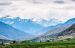
Nangarhār also called Nangrahar or Ningrahar, is one of the 34 provinces of Afghanistan, located in the eastern part of the country and bordering Logar, Kabul, Laghman and Kunar provinces as well as having an international border with Pakistan. It is divided into 22 districts and has a population of about 1,735,531, the third highest of the country's 34 provinces. The city of Jalalabad is the capital of Nangarhar province. Nangarhar province is famous for fish and karaye, and the popular tourist locations Daroonta and Pul-e- Sayad.

Nuristan, also spelled as Nurestan or Nooristan, is one of the 34 provinces of Afghanistan, located in the eastern part of the country. It is divided into seven districts and is Afghanistan's least populous province, with a population of around 167,000. Parun serves as the provincial capital. Nuristan is bordered on the south by Laghman and Kunar provinces, on the north by Badakhshan province, on the west by Panjshir province.
Kunar is one of the 34 provinces of Afghanistan, located in the northeastern part of the country. Its capital is Asadabad. Its population is estimated to be 508,224. Kunar's major political groups include Wahhabis or Ahl-e- Hadith, Nazhat-e Hambastagi Milli, Hezb-e Afghanistan Naween, Hezb-e Islami Gulbuddin.

The districts of Afghanistan, known as wuleswali, are secondary-level administrative units, one level below provinces. The Afghan government issued its first district map in 1973. It recognized 325 districts, counting wuleswalis (districts), alaqadaries (sub-districts), and markaz-e-wulaiyat. In the ensuing years, additional districts have been added through splits, and some eliminated through merges. In June 2005, the Afghan government issued a map of 398 districts. It was widely adopted by many information management systems, though usually with the addition of Sharak-e-Hayratan for 399 districts in total. It remains the de facto standard as of late 2018, despite a string of government announcements of the creation of new districts.

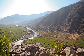
The Kūnaṛ River, also known as the Chitral River, Mastuj River and Kama River, is a 480 kilometres (300 mi) long river located in northern Pakistan and eastern Afghanistan. It originates just south of the Hindu Kush Mountains, in the north of Afghanistan's Badakhshan province. It later merges with Kabul river in the Nangahar Province of Afghanistan. The river system is fed by melting glaciers and snow of the Hindu Kush mountains. The Kunar is a tributary of the Kabul river, which is in turn a tributary of the Indus River.

Goshta District is located in the northeast of Nangarhar Province, Afghanistan and borders Durand Line between Afghanistan and Pakistan. The district's population is Pashtun and was estimated at 160,000 in 2002, of whom 30,000 were children under 12. The district is within the heartland of the Mohmand tribe of Pashtuns. The district centre is the village of Goshta, on the Kabul River.

Asadabad district is one of 15 districts in the Kunar Province of Afghanistan. It includes the city of Asadabad - the district center, close the Kunar River. It is situated in the central part of the province. It has 12 big and small villages, which are surrounded by mountains so there is not enough land for farming.

Marawara District is one of the 15 districts in Kunar Province, Afghanistan. It borders Sirkanay District to the west, Asadabad District to the north-west, Dangam District to the north-east and the Durand Line to the south. Marawara's population is not exactly known but government figures estimate it to be around 22,270 people, all of them being ethnic Pashtuns. Marawara village is the center of the district and is located in its westernmost part.
Bar Kunar District is situated in the northeastern part of Kunar Province, Afghanistan. It borders Asadabad district to the southwest, Nuristan Province to the northwest, Nari district to the northeast and Dangam district to the southeast. The population is 19,500 (2006) - all Pashtun. The district center is the village of Asmãr at 983 m elevation in a river valley, located in the most southern part of the district.
The district is mountainous and the arable land is not enough and people are poor. It is said that the fight against the Soviet Army started in this district.
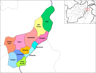
Dangam District is situated in the eastern end of Kunar Province in Afghanistan. It borders Marawara district to the southwest, Asadabad district to the west, Bar Kunar district to the north, Nari district to the northeast and Khyber Pakhtunkhwa in Pakistan to the east. The district is mountainous and stunning but also poor.
Nari (Naray) District is a mountainous district in the eastern part of Kunar Province in Afghanistan. It borders Bar Kunar District to the west, Nuristan Province to the north, Khyber Pakhtunkhwa to the east and Dangam district to the south. The population was reported in 2006 as 24,500 of which around 60% is ethnic Gawar (Kohistani). The district center is the village of Nari (Naray)35.2103°N 71.5250°E at 1153 m altitude in a river valley. The arable land is not enough. The residents usually collect wood and beans and sell them.

Narang, Kunar, Afghanistan نرنګ in Pashto and Persian is situated in the central part of Kunar Province, Afghanistan south of Asadabad. It is surrounded by high mountains and the Kunar River. The population is 36,700 (2014). The district center is the village of Kuz Narang at 742 m altitude. It is the kunar 2nd largest district regarding Agriculture Land. The irrigation system is under rehabilitation. The land is in much good condition and fertile. The irrigation system is almost the best in Kunar province. About 75% of the people are educated. The famous villages are: 1: Bar-Narhang 2: Kotkay 3: Badel dara 4: kuz-Narhang 5: Lamatak 6: dandona 7: Char qala 8: kodo ; etc.

Chawkay District is situated in the central part of Kunar Province, Afghanistan. The population was reported in 2006 as 31,600. The district center is the village of Chawkay at 726 m elevation in the valley of the Kunar River. Roughly 80% of the houses in the district were destroyed during the wars.

Nurgal District is in the western part of Kunar Province in Afghanistan, 45 kilometres (28 mi) west of the town of Asadabad, near the city of Jalalabad. It borders Nangarhar Province to the west and south, Chapa Dara district to the north and Chawkay and Khas Kunar districts to the east.
Khas Kunar or Sarkani(sarkano) District is the largest district in the Kunar Province, Afghanistan. It is situated in the southern part of the province and borders Nangarhar Province to the south and Pakistan to the east. The Kunar River passes north through the district and irrigates the surrounding land. The population was estimated to be 31,000 in 2006. The district center, Khas Kunar village is located at 34.6458°N 70.9008°E at 749 m altitude. Most of the houses were destroyed during the wars and droughts also have seriously affected the lands all around the Kunar River. The most influential person from this district was Kabir Stori, who was a Pashtun nationalist.

Sirkanay District is situated in the central part of Kunar Province, Afghanistan. It borders Pakistan to the south. The population is 39,292 (2019). The district administrative center is the village of Serkanay at 775 m altitude. To the north the district borders the Kunar River, which irrigates the small part of arable land. Drought is the major problem of the people. The majority of the houses (70%) were destroyed during the wars. Many young men live and work in Pakistan.

Dara-I-Pech District is located in western-central Kunar Province, Afghanistan, 30 km west of Asadabad. The population was 48,400 in 2006. The district is governed from Mano Gai. The governor is Mohammad Rahkman.
Kamdesh District is a district of Nuristan Province in eastern Afghanistan, sharing a name with the town of Kamdesh. It was originally in Kunar Province and then was moved to the newly created Nuristan Province in 2001.
On 23 February 2014, Taliban insurgents supported by Afghan insiders raided two ANA checkpoints located outside the city of Asadabad in the Ghaziabad District of Kunar province, Eastern Afghanistan. The raid marked the deadliest attack against Afghan security forces since 2010.
References
- 1 2 "Afghanistan Administrative Divisions" Archived September 23, 2010, at the Wayback Machine map, March 2007, Afghanistan Information Management Services (AIMS)
- ↑ "CSO 2003 - 2004 Population Statistics - 388 Districts" Archived August 11, 2007, at the Wayback Machine from Afghanistan Information Management Services (AIMS)
