Rajgir, old name Rajagriha, meaning "The City of Kings," is an ancient city and university town in the district of Nalanda in Bihar, India. As the ancient seat and capital of the Haryanka dynasty, the Pradyota dynasty, the Brihadratha dynasty and the Mauryan Empire, as well as the dwelling ground of such historical figures as Buddha, Mahavira and Bimbisara, the city holds a place of prominence in Hindu, Buddhist and Jain scriptures. As of 2011, the population of the town was reported to be 41,000 while the population in the community development block was about 88,500.
Pawapuri, or Pavapuri, is a holy site for Jains located in the Nalanda district of Bihar state in eastern India. It is located about 19 kilometres from Rajgir and 101 kilometres from Patna, the capital of Bihar. Pawapuri is Mahavira's nirvana and a pilgrimage site for Jains.

Bihar Sharif is the headquarters of Nalanda district and the fifth-largest sub-metropolitan area in the eastern Indian state of Bihar. Its name is a combination of two words: Bihar, derived from vihara, also the name of the state; and Sharif. The city is a hub of education and trade in southern Bihar, and the economy centers around agriculture supplemented by tourism, the education sector and household manufacturing. The ruins of the ancient Nalanda Mahavihara, a UNESCO World Heritage Site, are located near the city.

Nawada district is one of the thirty-eight districts of the Indian state of Bihar. Nawada is its administrative headquarters. The district is the easternmost district of the Magadh division, one of the nine administrative divisions of Bihar. The area of the modern district was historically part of the Magadha, Shunga and Gupta empires. Koderma and Giridih districts of the state of Jharkhand lie on the southern border of the district; it also shares borders with the Gaya, Nalanda, Sheikhpura, and Jamui districts of Bihar.
Nalanda district is one of the thirty-eight districts of the state of Bihar in India. Bihar Sharif is the administrative headquarters of this district. The districts is home to the ancient Nalanda Mahavihara a UNESCO World Heritage Site. Nalanda is located in the Magadh region of southern Bihar.

Bakhtiyarpur is a town and a municipality notified area, near Patna City in Patna district in the state of Bihar, India. Bakhtiyarpur is under the Patna Sahib, and is a Vidhan Sabha constituency of Bihar in Patna District under the Barh sub-division of Bihar. It is a major railway junction in Danapur railway division, ECR. The incumbent Chief Minister of Bihar, Nitish Kumar belongs to Bakhtiyarpur.
Warisaliganj is a Community Development block and a Municipal Council in Nawada district in the Indian state of Bihar.
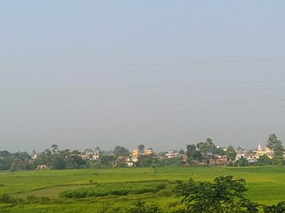
Baragaon is a village in Nalanda District of Bihar state, India. It is 2 kilometres (1.2 mi) from Nalanda Railway station toward north-west direction. It is known for its Chhath Puja celebrations, performed at a large pond in the village and attended by people from across northern Bihar. There is a big ancient temple of God Surya.
The state of Bihar in eastern India, is one of the oldest inhabited places in the world with a history going back 3000 years. The rich culture and heritage of Bihar is evident from the innumerable ancient monuments that are dotted all over the state. Bihar is home to many tourist attractions and is visited by large numbers of tourists from all over the world. Around total 6 million tourists visit Bihar every year.
Ekangarsarai is a census town and corresponding community development block in Nalanda district of Bihar state, India.

Harnaut is a Nagar panchayat and corresponding Block in the Nalanda District of Bihar, India. The Hindu, Buddhist and Jain pilgrim centres of Nalanda, Pawapuri, Rajgir, Bodh Gaya and Vaishali are all near Harnaut. The incumbent Chief Minister of Bihar, Nitish Kumar, is from Kalyan Bigha village near Harnaut.

Lohra Village Jamui district, state of Bihar in eastern India.

Rajgir railway station is a railway station serving the city of Rajgir in the Indian state of Bihar. Rajgir is in the Danapur railway division of the East Central Railway zone. Rajgir is well connected with Patna Junction, Harnaut, Jehanabad, Bihar Sharif, Gaya Junction, Islampur, Nawada and Bakhtiyarpur Junction through daily passenger and express train services. It is located near Jawahar Navodaya Vidyalaya Rajgir Nalanda.
Nayadih is a village among a block of villages in Derhgaon of the Kashichak Block, Nawada District, in Bihar, India. The main villages of Nayadih, Derhgaon and Bishwanathpur together have been referred to as Derhgaon.

Bihar Sharif Junction railway station, station code BEHS, is a railway station under Danapur railway division of East Central Railway. Bihar sharif is connected to metropolitan areas of India, by the Delhi–Kolkata main line via Mughalsarai–Patna route. Station is located in Bihar Sharif city in Nalanda district in the Indian state of Bihar. Due to its location on the Bakhtiyarpur–Tilaiya line, many trains from Patna and other cities via Bakhtiyarpur Junction, and trains coming from Rajgir and Gaya Junction stops here. Bihar Sharif has well connected trains running frequently to New Delhi, Patna Junction, Varanasi Junction, and Howrah Junction and with nearby cities Gaya Junction, Rajgir railway station, Tilaiya railway station, Bhagalpur railway station, Kiul Junction through daily passenger and express train services.

Naromurar is a Village in Warisaliganj Tehsil, located 10 km (6.2 mi) from National Highway 31 and 8 km (5.0 mi) from State Highway 59, making it the only village of the area well connected to both Nawada and Nalanda districts of Bihar.
Literally the word Nar means water and Murar means Lord Krishna who appeared as the 8th avatara of Lord Vishnu in Dvapara Yuga as mentioned in Garuda Purana, that is the word Naromurar means the house of lord Vishnu -Kshirsagar.
Naromurar is a village of great traditions. It is one of the ancient villages of India having a four hundred year older Thakur Wadi dedicated to Maryada Purushottam Ram and Lord Shiva.
Along with the Rajkiyakrit Madhya Vidyalay having established in 1920 AD, 27 years before the freedom of India, a Janta Pustakalay the Public Library is also started in the year of 1956 AD which was inaugurated by the Education Minister of Bihar during the time of Krishna Singh.

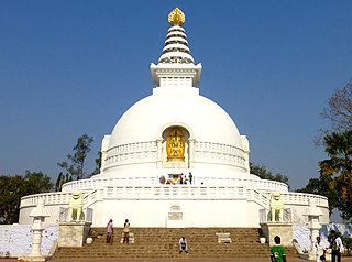
Giriyak is a village and community development block located on the bank of the Panchane River in Nalanda district of Bihar, India. It is located about 15 kilometres east of Rajgir, 26 kilometres south of Bihar Sharif, the district headquarters, and 95 kilometres southeast of Patna, the state capital.
Sheikhpura Junction railway station, station code SHK, is a railway station under Danapur railway division of East Central Railway. Sheikhpura is connected to metropolitan areas of India, by the Gaya–Kiul line. Station is located in Sheikhpura city in Sheikhpura district in the Indian state of Bihar. Due to its location on the Gaya–Kiul line, many trains coming from Gaya and other cities stops here. Sheikhpura is well connected with nearby cities Gaya, Nawada, Bhagalpur, Howrah and Kiul through daily passenger and express train services.
Kutri Village is located in the Warisaliganj Block of Nawada district in Bihar, India. It is a historical village among 80 villages of Warisaliganj Block of Nawada district. According to government records, Kutri village has 842 houses spread over a geographical area of 368 hectares. It is situated 5 km away from the Warisaliganj Block and 22 km away from Nawada. As of 2009, Kutri village was designated a gram panchayat.
Giriyak Stupa, also known as Jarasandha-ka-baithak, is an ancient cylindrical stupa located in the Nalanda district of Bihar, India.

