Pedology is a discipline within soil science which focuses on understanding and characterizing soil formation, evolution, and the theoretical frameworks for modeling soil bodies, often in the context of the natural environment. Pedology is often seen as one of two main branches of soil inquiry, the other being edaphology which is traditionally more agronomically oriented and focuses on how soil properties influence plant communities. In studying the fundamental phenomenology of soils, e.g. soil formation, pedologists pay particular attention to observing soil morphology and the geographic distributions of soils, and the placement of soil bodies into larger temporal and spatial contexts. In so doing, pedologists develop systems of soil classification, soil maps, and theories for characterizing temporal and spatial interrelations among soils. There are a few noteworthy sub-disciplines of pedology; namely pedometrics and soil geomorphology. Pedometrics focuses on the development of techniques for quantitative characterization of soils, especially for the purposes of mapping soil properties whereas soil geomorphology studies the interrelationships between geomorphic processes and soil formation.
Soil formation, also known as pedogenesis, is the process of soil genesis as regulated by the effects of place, environment, and history. Biogeochemical processes act to both create and destroy order (anisotropy) within soils. These alterations lead to the development of layers, termed soil horizons, distinguished by differences in color, structure, texture, and chemistry. These features occur in patterns of soil type distribution, forming in response to differences in soil forming factors.

Bentonite is an absorbent swelling clay consisting mostly of montmorillonite which can either be Na-montmorillonite or Ca-montmorillonite. Na-montmorillonite has a considerably greater swelling capacity than Ca-montmorillonite.

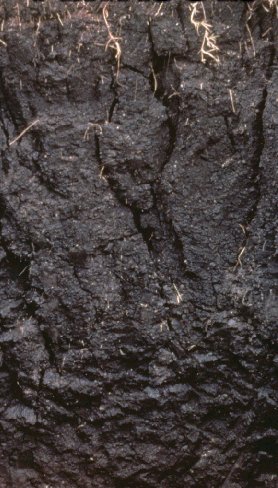
Chernozem, also called black soil, regur soil or black cotton soil, is a black-colored soil containing a high percentage of humus and high percentages of phosphorus and ammonia compounds. Chernozem is very fertile soil and can produce high agricultural yields with its high moisture storage capacity. Chernozems are a Reference Soil Group of the World Reference Base for Soil Resources (WRB)
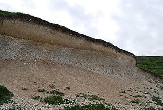
A vertisol is a Soil Order in the USDA soil taxonomy and a Reference Soil Group in the World Reference Base for Soil Resources (WRB). It is also defined in many other soil classification systems. In the Australian Soil Classification it is called vertosol. Vertisols have a high content of expansive clay minerals, many of them belonging to the montmorillonites that form deep cracks in drier seasons or years. In a phenomenon known as argillipedoturbation, alternate shrinking and swelling causes self-ploughing, where the soil material consistently mixes itself, causing some vertisols to have an extremely deep A horizon and no B horizon.. This heaving of the underlying material to the surface often creates a microrelief known as gilgai.
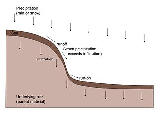
A soil horizon is a layer parallel to the soil surface whose physical, chemical and biological characteristics differ from the layers above and beneath. Horizons are defined in many cases by obvious physical features, mainly colour and texture. These may be described both in absolute terms and in terms relative to the surrounding material, i.e. 'coarser' or 'sandier' than the horizons above and below.
Claypan is a dense, compact, slowly permeable layer in the subsoil. It has a much higher clay content than the overlying material, from which it is separated by a sharply defined boundary. The dense structure restricts root growth and water infiltration. Therefore, a perched water table might form on top of the claypan. In the Canadian classification system, claypan is defined as a clay-enriched illuvial B (Bt) horizon.

Mima mounds are low, flattened, circular to oval, domelike, natural mounds that are composed of loose, unstratified, often gravelly sediment that is an overthickened A horizon. These mounds range in diameter from 3 m (9.8 ft) to more than 50 m (160 ft); in height 30 cm (12 in) to greater than 2 m (6.6 ft); and in density from several to greater than 50 mounds per hectare, at times forming conspicuous natural patterns. Mima mounds can be seen at the Mima Mounds Natural Area Preserve in Washington state.

A gleysol or gley soil is a hydric soil that unless drained is saturated with groundwater for long enough to develop a characteristic gleyic colour pattern. The pattern is essentially made up of reddish, brownish, or yellowish colours at surfaces of soil particles and/or in the upper soil horizons mixed with greyish/blueish colours inside the peds and/or deeper in the soil. Gleysols are also known as Gleyzems, meadow soils, Aqu-suborders of Entisols, Inceptisols and Mollisols, or as groundwater soils and hydro-morphic soils.
A fragipan is a diagnostic horizon in USDA soil taxonomy. They are altered subsurface soil layers that restrict water flow and root penetration. Fragipans are similar to a duripan in how they affect land-use limitations. In soil descriptions, they are commonly denoted by a Bx or Btx symbol. They often form in loess ground. The first record of fragipans is probably that by John Hardcastle in New Zealand in the 1880s.
Soil resilience refers to the ability of a soil to resist or recover their healthy state in response to destabilising influences. This is a subset of a notion of environmental resilience. Soil resistance, a related term refers to the ability of soil to resist changes or the extent to which a soil will recover from any cropping or management change. The term is distinct from Soil resilience as resistance is the inherent capacity to withstand disturbance, while resilience is the capacity to recover after disturbance.
The shrink–swell capacity of soils refers to the extent certain clay minerals will expand when wet and retract when dry. Soil with a high shrink–swell capacity is problematic and is known as shrink–swell soil, or expansive soil. The amount of certain clay minerals that are present, such as montmorillonite and smectite, directly affects the shrink-swell capacity of soil. This ability to drastically change volume can cause damage to existing structures, such as cracks in foundations or the walls of swimming pools.

A Planosol in the World Reference Base for Soil Resources is a soil with a light-coloured, coarse-textured, surface horizon that shows signs of periodic water stagnation and abruptly overlies a dense, slowly permeable subsoil with significantly more clay than the surface horizon. In the US Soil Classification of 1938 used the name Planosols, whereas its successor, the USDA soil taxonomy, includes most Planosols in the Great Groups Albaqualfs, Albaquults and Argialbolls.
A catena in soil science (pedology) is a series of distinct but co-evolving soils arrayed down a slope. Each soil type or "facet" differs somewhat from its neighbours, but all occur in the same climate and on the same underlying parent material. A mature catena is in equilibrium as the processes of deposition and erosion are in balance.

Soil aggregate stability is a measure of the ability of soil aggregates—soil particles that bind together—to resist breaking apart when exposed to external forces such as water erosion and wind erosion, shrinking and swelling processes, and tillage. Soil aggregate stability is a measure of soil structure and can be affected by soil management.

Selam is a tabia or municipality in the Dogu'a Tembien district of the Tigray Region of Ethiopia. The tabia centre is in Addi Werho village, located approximately 3 km to the northeast of the woreda town Hagere Selam.

Lim’at is a tabia in the Dogu'a Tembien district of the Tigray Region of Ethiopia. The tabia centre is in Maygwa village, located approximately 8 km to the southwest of the woreda town Hagere Selam.

The soils of the Kilte Awula’ilo woreda (district) in Tigray, Ethiopia reflect its longstanding agricultural history, highly seasonal rainfall regime, relatively low temperatures, the presence of a wide depression at the foot of the Atsbi horst and steep slopes. Outstanding features in the soilscape are the wide ancient fluvial deposits, the soils of the granite batholith, cuestas and fertile lands behind tufa dams.
The soils of the Inderta woreda (district) in Tigray (Ethiopia) reflect its longstanding agricultural history, highly seasonal rainfall regime, relatively low temperatures, overall dominance of limestone and dolerite lithologies and steep slopes. Outstanding features in the soilscape are wide plains with Vertisols.

The soils of the Dogu’a Tembien woreda (district) in Tigray (Ethiopia) reflect its longstanding agricultural history, highly seasonal rainfall regime, relatively low temperatures, an extremely great variety in lithology and steep slopes. Outstanding features in the soilscape are the fertile highland Vertisols and Phaeozems in forests.
