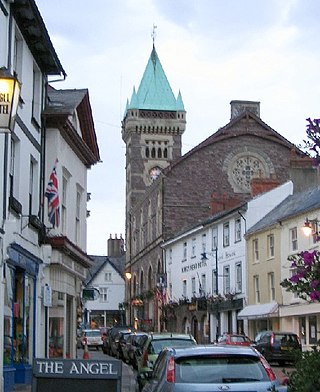
Abergavenny is a market town and community in Monmouthshire, Wales. Abergavenny is promoted as a "Gateway to Wales"; it is approximately 6 miles (10 km) from the border with England and is located where the A40 trunk road and the recently upgraded A465 Heads of the Valleys road meet.

The River Usk rises on the northern slopes of the Black Mountain, Wales, in the westernmost part of the Brecon Beacons National Park. Initially forming the boundary between Carmarthenshire and Powys, it flows north into Usk Reservoir, then east by Sennybridge to Brecon before turning southeast to flow by Talybont-on-Usk, Crickhowell and Abergavenny, after which it takes a more southerly course.

The A465 is a trunk road that runs from Bromyard in Herefordshire, England to Llandarcy near Swansea in south Wales. The western half in Wales is known officially as the Neath to Abergavenny Trunk Road, but the section from Abergavenny to the Vale of Neath is more commonly referred to as the Heads of the Valleys Road because it links the northern heads of the South Wales Valleys. That section was also the subject to an improvement programme which sections 1 to 4 are complete, and sections 5 to 6 under construction and due to finish in 2025. Approximately following the southern boundary of the Brecon Beacons National Park, the Ordnance Survey Pathfinder guide describes it as the unofficial border between rural and industrial South Wales. The A465 provides an alternative route between England and the counties in South West Wales and to the ferries to Ireland.
Llanelly is the name of a parish and coterminous community in the principal area of Monmouthshire, within the historic boundaries of Brecknockshire, south-east Wales. It roughly covers the area of the Clydach Gorge. The population of the parish and ward at the 2011 census was 3,899.
Thomas Dadford Jr. was an English canal engineer, who came from a family of canal engineers. He first worked with his father in the north of Britain on the Stour and the Trent, but later independently, contributing to a number of canal schemes, mainly in Monmouthshire and Glamorganshire but also in Montgomeryshire and Ellesmere, before dying at the age of 40.
John Dadford was an English canal engineer, as were his father Thomas Dadford and brothers Thomas Dadford, Jr. and James Dadford. He lived from approximately 1769 to 1800, although neither date is known for certain.

Company Sergeant Major John Henry Williams, was a Welsh colliery worker, soldier, and a recipient of the Victoria Cross (VC) the highest award for gallantry in the face of the enemy that can be awarded to British and Commonwealth forces. Williams is the most decorated Welsh non-commissioned officer of all time.
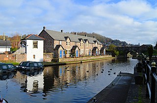
The Monmouthshire and Brecon Canal is a small network of canals in South Wales. For most of its currently (2018) navigable 35-mile (56 km) length it runs through the Brecon Beacons National Park, and its present rural character and tranquillity belies its original purpose as an industrial corridor for coal and iron, which were brought to the canal by a network of tramways and/or railroads, many of which were built and owned by the canal company.
Talybont-on-Usk is a village and community in Powys, Wales, in the historic county of Brecknockshire. It lies on both the Caerfanell river and the Monmouthshire and Brecon Canal, about 1 mile (1.6 km) from the River Usk. In 2001, it had a population of 743, reducing to 719 at the 2011 census. The community includes the settlements of Llansantffraed, Scethrog, Aber Village, and Pencelli.

The Swansea Canal was a canal constructed by the Swansea Canal Navigation Company between 1794 and 1798, running for 16.5 miles (26.6 km) from Swansea to Hen Neuadd, Abercraf in South Wales. It was steeply graded, and 36 locks were needed to enable it to rise 373 feet (114 m) over its length. The main cargos were coal, iron and steel, and the enterprise was profitable.

Kemeys Commander is a village in Monmouthshire, in South East Wales.

Llangynidr is a village, community and electoral ward in Powys, Wales, about 4 miles (6.4 km) west of Crickhowell and 9 miles (14.5 km) south-east of Brecon. The River Usk flows through the village as does the Monmouthshire and Brecon Canal. It is in the historic county of Brecknockshire.
Clydach is a village in Monmouthshire, Wales. Its nearest neighbours are the village of Gilwern and town of Abergavenny.

Govilon is a small Welsh village located between Llanfoist and Gilwern near Abergavenny in north Monmouthshire. It is part of the community of Llanfoist Fawr. The population was 1,447 in 2011.
The Merthyr, Tredegar and Abergavenny Railway, also known as the Heads of the Valleys line, was a railway line which operated between 1860 and 1958 between the Monmouthshire town of Abergavenny and the Glamorgan town of Merthyr Tydfil in South East Wales.

The Clydach Gorge is a steep-sided valley in south-east Wales down which the River Clydach flows to the River Usk.
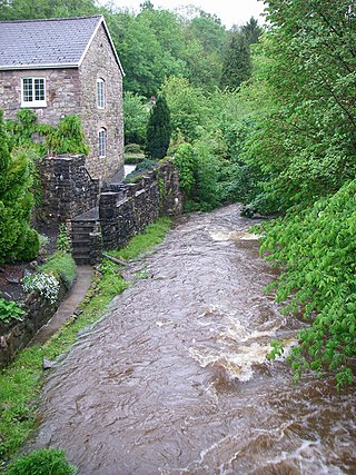
The River Clydach is a short, steep and fast-flowing river in Monmouthshire and the county borough of Blaenau Gwent in south Wales. It lies within the Brecon Beacons National Park. It is around 10 kilometres (6 mi) in length.

Mynydd Llangatwg or Llangattock Mountain is a hill in the Brecon Beacons National Park in the county of Powys, south Wales. It is named from the village of Llangatwg which sits in the valley of the River Usk to the north of it. It is essentially an undulating plateau rising in the west to a height of 530 metres (1,740 ft) at grid reference SO171157 and in the east to a height of 529 metres (1,736 ft) at Hen Dy-aderyn / Twr Pen-cyrn. This spot is marked by a trig point. The shallow pool of Pwll Gwy-rhoc sits in a broad depression towards the northern edge of the plateau whilst a smaller pool frequently occupies a large shakehole a few hundred metres to its west. The hill forms an impressive northern scarp overlooking the Usk valley and commonly referred to as the Llangattock Escarpment. Its southern margins are more subdued. Its eastern end is defined by the drops into the Clydach Gorge. Beyond the B4560 to the west the hill merges with Mynydd Llangynidr which has a similar character.

Llanfrynach is a village and community in the county of Powys, Wales, and the historic county of Brecknockshire. The population of the community as taken at the 2011 census was 571. It lies just to the southeast of Brecon in the Brecon Beacons National Park. The village sits astride the Nant Menasgin, a right bank tributary of the River Usk. The B4558 passes just to its north and the Monmouthshire and Brecon Canal also passes around the village. The Welsh name signifies the 'church of Brynach'. The community includes the hamlets of Llanhamlach and Groesffordd.
The Gwent Central League is a football league covering the central part of the preserved county of Gwent. It is affiliated to the Gwent County Football Association. The leagues are at the seventh and eighth levels of the Welsh football league system. It was previously known as the Pontypool & District League, and the North East Gwent League.

