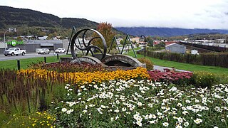
Gitsegukla (also variants of Kitsegeucla or Skeena Crossing) is an unincorporated community in the Skeena region of west central British Columbia, Canada. The place is on the southeast side of the Skeena River adjacent to the Kitseguecla River mouth.[1] On BC Highway 16, the locality is by road about 94 kilometres (58mi) northwest of Smithers and 113 kilometres (70mi) northeast of Terrace.
In the Gitxsan language, Gitsegukla means the "people living under the precipice" or more specifically under the "Segukla" or "sharp-pointed" mountain,[2] a reference to the characteristics of Kitseguecla Mountain.[3] By the 1890s, the Kitseguecla River name was well established.[4]
The name Skeena Crossing alluded to the railway bridge construction. The earliest newspaper references were June 1910 to Skeena crossing[5] and October 1910 to Skeena Crossing, a steamboat stop.[6]
First Nations
First Nations have inhabited the area for over six thousand years.[7]
During the Omineca Gold Rush the Skeena River became a supply route for miners and traders to the northern interior.[8] Kitsegukla, which was one of the seven Gitxsan winter villages, lay in a small canyon a short distance below the present village. About a dozen longhouses accommodated the village of 250–300 people.[9] In early June 1872, a party in two canoes carrying both European and indigenous occupants failed to fully extinguish their camp fire at an adjacent site.[10] The resulting blaze destroyed 12 totem poles, the longhouses, and the contents. Beside the cultural loss, the monetary value was estimated at $6,000.[11]
During the preceding period, seven Gitxsan members had drowned while carrying freight for a Hazelton merchant in their canoes. These combined events prompted a Gitsegukla blockade of the river.[12] Consequently, the merchant paid compensation for the drownings.[13] A few weeks after the fire, the blockade was lifted on the understanding that the government would compensate for the fire loss.[14] When a settlement did not appear imminent, the Gitsegukla again closed the river to freight traffic.[15]
A delegation of five Gitsegukla chiefs travelled to Metlakatla to meet Lieutenant GovernorTrutch, who arrived aboard the HMS Scout in early August.[16] Trutch warned the chiefs not to repeat such blockades and made what he considered a $600 ex gratia payment.[17] Subsequently, the community moved slightly upriver to the second village.[7]
In 1885, when Methodist missionary Rev. W.H. Pierce came,[18] he was loaned a building for a residence, church services, and a day school.[19] The next year, a new building was erected for this purpose.[20] During the 1889–90 winter, the Christians relocated upriver to form a new village in what became the Carnaby area. The village was called New Kitzegucla.[21]
Gitxsan village, Gitsegukla, 1926.
In 1892, most returned to the former village. In 1895, the remainder returned and Rev. Pierce left for the coast. A series of missionaries then filled the Kitzegucla posting.[22] A few families moved downriver to the village at Andimaul, where the Salvation Army ministered.[23] The Methodist Church, which became part of the United Church, ran the federal government-funded Kitsegukla First Nations school 1897–1985.[24]
The second village lost many houses in the 1914 flood and every structure in the 1936 flood, which prompted the move to the current higher site.[7]
In 2021, the population on the reserve was 444.[27]
The community lies on the Gitsegukla Indian Reserve No. 1.[28] The Gitsegukla Elementary School (grades K–7) infuses the BC curriculum with Gitxsan culture.[29] The United church building remains standing.[30] The community possesses neither a gas station nor convenience store.[31]
Steamboats and ferries
In fall 1906, the small sternwheelerPheasant steamed up the Skeena to two spots to blast out rocks hindering navigation. On encountering low water when returning downstream, the vessel became wrecked upon protruding rocks.[32] The location was Redrock Canyon near the later railway bridge.[33]
The powerful outflow of the Kitseguecla River forms the long Jackman's Eddy in the Kitseguecla Rapids. The swift white water of the rapids has been one of the more challenging parts of the Skeena River.[34]
In February 1911, a ferry charter across the Skeena was tendered.[37] The cable ferry operated until the bridge was completed. The fare to cross was 50 cents.[38]
When the 1912 river season commenced, only the FW&S Omineca was needed for the run from the crossing to Sealey.[39]
Skeena Crossing bridge and railway construction
In July 1911, the western abutment of the bridge was finished.[40] That October, work commenced on the piers.[41] The substructure comprises the abutments and two concrete piers in the river[42] and one on land.[38]
In March 1912, the eastward advance of the GTP rail head from Prince Rupert reached the bridge.[43] That June, a scheduled Prince Rupert–Skeena Crossing service replaced construction trains from Vanarsdol.[44]
In early July the superstructure was complete and the rail head proceeded an additional 6 kilometres (4mi) eastward.[45] Built by the Canadian Bridge Company, the length is 288 metres (945ft) and the height above the river is 50 metres (160ft).[38] About a week later, an intoxicated man fell from the bridge and assumedly drowned.[46]
That September, the GTP telegraph and freight office moved to Sealey.[47]
During World War II, the former hotel housed the troops who guarded the bridge.[38]
Road passengers and freight
A stage ran to the Hazelton area during wintertime.[48] Immediately upstream of the bridge construction,[49] an aerial tramway was installed across the Skeena in March 1912, similar to the one at Kitselas Canyon. At that time, stables were built to house about 100 horses for hauling wagons to the Hazelton area.[50] That year, passengers completed their journey by either ferrying across the Skeena and taking a stage to Hazelton[51] or boarding a steamboat.[52]
Heavy rains in 1934 undermined the highway bridge over the Kitsequecla River, rendering it unsafe.[53] In 1938–39, the structure was replaced.[54]
In 1958, Western Coach Lines inaugurated a Prince Rupert–Prince George bus service,[55] which included a scheduled stop at Skeena Crossing.[56]
The current passenger transit providers for Gitsegukla are BC Bus North[57] and BC Transit.[58]
Railway operations
By 1914, the place was a unofficial flag stop.[59]
The development of several claims on Rocher Déboulé Mountain prompted the province to build an 18-kilometre (11mi) winding road to Skeena Crossing. Although way freights stopped at that location, the GTP refused to construct a siding and station. In response to complaints, the Railway Commission ordered the GTP in 1916 to install a siding and small station within 30 days.[60][61]
Byron Robert Jones[38] was a merchant at least from 1912.[79] He was the inaugural postmaster 1914–1917.[80]
Comprising about 20 guest rooms, his hotel was completed in May 1914[81] and a liquor licence application lodged for the Copper Tavern that August.[82] The official opening was soon afterward. At the time, the settlement only had a few houses.[59] The hotel was considered one of the finer establishments in Western Canada.[38] The Chalcopyrite newspaper published from June[83] to November that year.[84]
In 1920, the contents of the Copper Tavern were auctioned.[85] Under new management, the tavern may have operated into the late 1920s.[86]
A general store with gas bar existed immediately southwest of the railway bridge on Skeena Crossing Rd (former highway) at least until the 1980s.[38][87]
↑ "Interior News". www.newspapers.com. 17 Nov 1920. p.3. A large number of people from this town attended the auction sale at the Copper Tavern at Skeena Crossing last Wednesday, with the result that the next freight train brought a large and varied assortment of furniture, linens, etc., for the various buyers.
Highway 16 is a highway in British Columbia, Canada. It is an important section of the Yellowhead Highway, a part of the Trans-Canada Highway that runs across Western Canada. The highway closely follows the path of the northern B.C. alignment of the Canadian National Railway (CN). The number "16" was first given to the highway in 1941, and originally, the route that the highway took was more to the north of today's highway, and it was not as long as it is now. Highway 16 originally ran from New Hazelton east to Aleza Lake. In 1948, Highway 16's western end was moved from New Hazelton to the coastal city of Prince Rupert, and in 1953, the highway was re-aligned to end at Prince George. In 1969, further alignment east into Yellowhead Pass was opened to traffic after being constructed up through 1968 and raised to all-weather standards in 1969. Highway 16's alignment on Haida Gwaii was commissioned in 1983 and is connected to the mainland segment via BC Ferries route #11.
Terrace is a city in the Skeena region of northwestern British Columbia, Canada. This regional hub lies east of the confluence of the Kitsumkalum River into the Skeena River. On BC Highway 16, junctions branch northward for the Nisga'a Highway to the west and southward for the Stewart–Cassiar Highway to the east. The locality is by road about 204 km (127 mi) southwest of Smithers and 144 km (89 mi) east of Prince Rupert. Transportation links are the Northwest Regional Airport, a passenger train, and bus services.
Hazelton is a village municipality in the Skeena region of west central British Columbia, Canada. The place is on the southeast side of the Skeena River immediately north of the Bulkley River mouth, where the confluence forms a peninsula. On BC Highway 62, the locality is by road about 75 kilometres (47 mi) northwest of Smithers and 144 kilometres (89 mi) northeast of Terrace. Hazelton is the original of the "Three Hazeltons", the other two being New Hazelton to the southeast and South Hazelton to the south.
Usk is an unincorporated community in the Skeena region of west central British Columbia, Canada. The Usk Ferry connects the two parts of the hamlet that straddle the Skeena River. Just off BC Highway 16, the locality is by road about 182 kilometres (113 mi) west of Smithers and 23 kilometres (14 mi) northeast of Terrace.
Seton Lake is a lake in the Squamish-Lillooet region of southwestern British Columbia. On the northeast side is Mission Ridge. On the southwest is the Cayoosh Range. By road, the eastern end is about 7 kilometres (4.3 mi) southwest of Lillooet.
Alexandra Bridge Park lies within the lower Fraser Canyon of British Columbia, Canada. This provincial park is adjacent to the historic suspension bridge from 1926, which spans the Fraser River and was built using the eastern abutment of the bridge from 1863. The locality, on BC Highway 1, is by road about 44 kilometres (27 mi) north of Hope and 65 kilometres (40 mi) south of Lytton.
Babine Lake borders the Skeena and Omineca regions of central British Columbia, Canada. Vehicle access to the lake, via BC Highway 16 and Nilkitkwa forestry service road, is by road about 105 kilometres (65 mi) northeast of Smithers; via BC Highway 16 and Central Babine Lake Highway, is about 132 kilometres (82 mi) east of Smithers; or via Babine Lake Road, is about 20 kilometres (12 mi) northeast of Burns Lake.
Gitxsan are an Indigenous people in Canada whose home territory comprises most of the area known as the Skeena Country in English. Gitksan territory encompasses approximately 35,000 km2 (14,000 sq mi) of land, from the basin of the upper Skeena River from about Legate Creek to the Skeena's headwaters and its surrounding tributaries. Part of the Tsimshianic language group, their culture is considered to be part of the civilization of the Indigenous peoples of the Pacific Northwest Coast, although their territory lies in the Interior rather than on the Coast. They were at one time also known as the Interior Tsimshian, a term which also included the Nisga'a, the Gitxsan's neighbours to the north. Their neighbours to the west are the Tsimshian while to the east the Wetʼsuwetʼen, an Athapaskan people, with whom they have a long and deep relationship and shared political and cultural community.
New Hazelton is a district municipality on the south side of the Bulkley River in the Skeena region of west central British Columbia, Canada. On BC Highway 16, the locality is by road about 68 kilometres (42 mi) northwest of Smithers and 137 kilometres (85 mi) northeast of Terrace. New Hazelton is one of the "Three Hazeltons", the other two being the original "Old" Hazelton to the northwest and South Hazelton to the west.
Kitwanga or Gitwangak is in the Skeena region of west central British Columbia. Among the Hazelton and Bulkley Mountain Ranges, the place is on the north shore of the Skeena River, east of the Kitwanga River confluence. On BC Highway 37, northeast of the junction with BC Highway 16, the locality is by road about 115 kilometres (71 mi) northwest of Smithers, 99 kilometres (62 mi) northeast of Terrace, and 212 kilometres (132 mi) southeast of Stewart.
Alexandria or Fort Alexandria was a general area encompassing a trading post, ferry site, and steamboat landing in the North Cariboo region of central British Columbia. The present unincorporated community is on the eastern side of the Fraser River. On BC Highway 97, the locality is by road about 74 kilometres (46 mi) northwest of Williams Lake and 45 kilometres (28 mi) south of Quesnel.
Kitselas Canyon is a canyon carved by the Skeena River in the Skeena region of west central British Columbia, Canada. Off BC Highway 16, the landmark is by road about 185 kilometres (115 mi) west of Smithers and 20 kilometres (12 mi) northeast of Terrace.
Kitselas is a railway point on the northwestern shore of the Skeena River in the Skeena region of west central British Columbia, Canada. The former name was Vanarsdol. Across the Skeena to the southwest is the mouth of the Zymoetz River. This river bridge on BC Highway 16 is by road about 10 kilometres (6 mi) northeast of Terrace.
Cedarvale is an unincorporated community in the Skeena region of west central British Columbia. Concentrated on the southeastern shore of the Skeena River, no direct link exists to the portion on the northwestern shore. On BC Highway 16, the locality is by road about 130 kilometres (81 mi) northwest of Smithers and 75 kilometres (47 mi) northeast of Terrace.
South Hazelton is an unincorporated community in the Skeena region of west central British Columbia, Canada. The place is on the east side of the Skeena River immediately south of the Bulkley River mouth. On BC Highway 16, the locality is by road about 73 kilometres (45 mi) northwest of Smithers and 132 kilometres (82 mi) northeast of Terrace. South Hazelton is one of the "Three Hazeltons", the other two being the original "Old" Hazelton to the north and New Hazelton to the east.
Pacific is a railway point in the Skeena region of west central British Columbia. On the western shore of the Skeena River, no direct link exists to the highway section on the eastern shore near the mouth of Legate Creek. On BC Highway 16, the locality is by road about 164 kilometres (102 mi) west of Smithers and 40 kilometres (25 mi) northeast of Terrace.
Isle Pierre is a railway point in the Nechako Region of central British Columbia. The scattered community straddles the shores of the Nechako River. The west side, off BC Highway 16, is by road about 55 kilometres (34 mi) west of Prince George and 69 kilometres (43 mi) east of Vanderhoof. The east side is by road about 46 kilometres (29 mi) west of Prince George.
Miworth is an unincorporated community on the southeast shore of the Nechako River in the Nechako Region of central British Columbia. The location, via Otway Rd and Miworth Rd, is about 16 kilometres (10 mi) northwest of Prince George.
Anderson Flats Park is in the Skeena region of west-central British Columbia, Canada. This provincial park is on the southeast shore at the junction of the Skeena River and Buckley River, between South Hazelton and "Old" Hazelton. Off BC Highway 16, the locality is by road about 73 kilometres (45 mi) northwest of Smithers and 132 kilometres (82 mi) northeast of Terrace.
Remo is an unincorporated community in the Skeena region of west central British Columbia. Concentrated on the northwestern shore of the Skeena River and immediately northeast of the Zymagotitz River mouth, no direct link exists to the portion on the southeastern shore. On BC Highway 16, the locality is by road about 10 kilometres (6 mi) southwest of Terrace.
This page is based on this Wikipedia article Text is available under the CC BY-SA 4.0 license; additional terms may apply. Images, videos and audio are available under their respective licenses.