Gizo, Solomon Islands

Last updated
Gizo
Town
Gizo Water front 3.jpg
A view of Waterfront Market place in Gizo
Solomon Islands adm location map.svg
Red pog.svg
Gizo
Location in Solomon Islands
Coordinates: 8°06′20″S156°50′20″E / 8.10556°S 156.83889°E / -8.10556; 156.83889
Country Solomon Islands
Province Western Province
Island Ghizo
Population
 (2019)
  Total7,177
Coral reef in Gizo near the airfield Korallenriff-Gizo.jpg
Coral reef in Gizo near the airfield

Gizo is the capital of the Western Province in Solomon Islands. With a population of 7,177 (as of 2019), it is the third largest town in the country. [1] It is situated on Ghizo Island approximately 380 kilometres (236 miles) west-northwest of the capital, Honiara, and is just southwest of the larger island of Kolombangara.

Contents

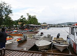
Gizo has a small landing strip on the nearby island of Nusatupe to the north east of the town, making it relatively developed compared to other settlements in the general vicinity. These days Gizo is a tourism centre with diving and surfing being popular activities.

History

This area of Solomon Islands has had a history of headhunting. According to local stories the Gizo tribe were notorious in this activity. As a consequence the surrounding local tribes took the unusual step of joining together to obliterate the Gizo tribe. The stories further relate that the only survivors were a Gizo woman and her son.

This event led to Ghizo island being declared as a property of the state, rather than the usual customary ownership prevalent in much of the rest of the Solomons. As a secondary consequence becoming an administrative and business centre because of the relative ease with which registered land titles could be obtained.

The Methodist Mission in the Western Province was established by Rev. John Frances Goldie in 1902. He dominated the mission and gained the loyalty of Solomon Islander members of his church. [2] The relationship with the colonial administrators of the British Solomon Island Protectorate were also fraught with difficulty, at this time due to Goldie's effective control over the Western Solomon Islands. [2]

From 1927 to 1934 Dr Edward Sayers worked at the Methodist mission where he established a hospital at Gizo and also at Munda and Vella Lavella, and carried out fieldwork in the treatment of malaria. [3]

St. Peter's Cathedral, [4] also called Gizo Cathedral, is the cathedral affiliated to the Catholic Church that is located in Gizo. It was inaugurated and blessed by Bishop EJ Crawford on June 18, 1964. [5]

World War II

In 1942, the islands were occupied by imperial Japanese troops.

Gizo was the operating base for Robert Ballard's The Search for Kennedy's PT 109 , which was a National Geographic Channel television special. The son of Eroni Kumana, who was one of the two natives that found the shipwrecked Lt. John F. Kennedy and his surviving men, lives on the island. The three islands, Plum Pudding, Olasana, and Naru, that were visited by the PT 109 survivors lie just to the southeast of Ghizo island.

The 2007 Solomon Islands earthquake

On 2 April 2007 Gizo was hit by a tsunami caused by the 8.1 magnitude earthquake centred only 25 miles from the town. Now known as the 2007 Solomon Islands earthquake the final official death total throughout the Western Province and Choiseul was 52. The tsunami hit during daylight hours, giving people warning to seek higher ground, as the tide withdrew in advance of the wall of water. Ten metre-high waves hit nearby Sasamunga (to the north-east of Gizo on the island of Choiseul), destroying houses, food gardens and a hospital. [6]

2010 earthquakes

Magnitude 7.2 and 6.5 quakes hit near the Solomon Islands in the South Pacific less than an hour apart on January 4, 2010. The larger quake was centered 65 miles south-southeast of Gizo, Solomon Islands, and at a depth of 19 miles. The smaller quake was 55 miles south-southeast of Gizo at a depth of 6.2 miles.

2011 tsunami

On March 11 Gizo was put under tsunami warning following a 9.0 magnitude earthquake off Japan's east coast.

Climate

Ghizo has a tropical rainforest climate (Af) with heavy to very heavy rainfall year-round.

Climate data for Ghizo
MonthJanFebMarAprMayJunJulAugSepOctNovDecYear
Mean daily maximum °C (°F)30.9
(87.6)
30.8
(87.4)
30.7
(87.3)
30.4
(86.7)
30.4
(86.7)
29.9
(85.8)
29.2
(84.6)
29.3
(84.7)
29.8
(85.6)
30.5
(86.9)
30.8
(87.4)
31.0
(87.8)
30.3
(86.5)
Daily mean °C (°F)27.4
(81.3)
27.3
(81.1)
27.2
(81.0)
27.0
(80.6)
27.1
(80.8)
26.7
(80.1)
26.3
(79.3)
26.2
(79.2)
26.6
(79.9)
27.0
(80.6)
27.2
(81.0)
27.4
(81.3)
26.9
(80.5)
Mean daily minimum °C (°F)23.9
(75.0)
23.8
(74.8)
23.8
(74.8)
23.7
(74.7)
23.8
(74.8)
23.5
(74.3)
23.4
(74.1)
23.2
(73.8)
23.4
(74.1)
23.5
(74.3)
23.7
(74.7)
23.8
(74.8)
23.6
(74.5)
Average precipitation mm (inches)413
(16.3)
353
(13.9)
385
(15.2)
292
(11.5)
272
(10.7)
258
(10.2)
367
(14.4)
285
(11.2)
267
(10.5)
247
(9.7)
246
(9.7)
284
(11.2)
3,669
(144.5)
Source: Climate-Data.org [7]

Government

Construction on the Correctional Services of Solomon Islands Gizo Correctional Centre in Gizo began in December 2010. [8]

  1. About Gizo Dive Gizo
  2. 1 2 Dr. Debra McDougall (2008). "Religious institutions as Alternative Structures in post-conflict Solomon Islands: Cases from Western Province". For State, Society and Governance in Melanesia Discussion Paper Series, 08/05, Australian National University. Archived from the original on 18 September 2014. Retrieved 4 Oct 2011.
  3. Sayers , E. G. (1943) Malaria in the South Pacific with Special Reference to the Solomon Islands. New Zealand Government Printing Office
  4. Cathedral of St. Peter in Gizo
  5. Moore, Clive. "St. Peter's Catholic Cathedral, Gizo - Place - Solomon Islands Historical Encyclopaedia". www.solomonencyclopaedia.net. Retrieved 2017-02-11.
  6. 13 dead following Solomons tsunami CNN, 2 April 2007
  7. "Climate: Ghizo". Climate-Data.org. Retrieved 21 October 2020.
  8. "Work starts on new Gizo Correctional Centre Archived 2010-12-07 at the Wayback Machine ." Solomon Star . Monday 6 December 2010. Retrieved on 11 March 2011.

Related Research Articles

<span class="mw-page-title-main">Geography of the Solomon Islands</span>

Solomon Islands is an island country in the South Pacific Ocean, that lies east of Papua New Guinea.

<span class="mw-page-title-main">Munda, Solomon Islands</span>

Munda is the largest settlement on the island of New Georgia in the Western Province of Solomon Islands, and consists of a number of villages. It is located at the southwestern tip of the western end of New Georgia, and the large Roviana Lagoon is just offshore.

<span class="mw-page-title-main">New Georgia Islands</span> Island group

The New Georgia Islands are part of the Western Province of Solomon Islands. They are located to the northwest of Guadalcanal. The larger islands are mountainous and covered in rain forest. The main islands are New Georgia, Vella Lavella, Kolombangara, Ghizo, Vangunu, Rendova and Tetepare. They are surrounded by coral reefs and include the Marovo Lagoon.

<span class="mw-page-title-main">New Georgia</span> Largest of the islands in Western Province, Solomon Islands

New Georgia, with an area of 2,037 km2 (786 sq mi), is the largest of the islands in Western Province, Solomon Islands, and the 224th-largest island in the world.

<span class="mw-page-title-main">Western Province (Solomon Islands)</span> Province in Gizo, Solomon Islands

Western Province is the largest of the nine provinces of Solomon Islands. The area is renowned for its beautiful tropical islands, excellent diving and snorkelling, coral reefs and World War II wrecks, ecotourism lodges, and head-hunting shrines. The province contains many small lagoons and most of the country's tourist trade outside Honiara.

<span class="mw-page-title-main">Choiseul Province</span> Province in Taro Island, Solomon Islands

Choiseul Province is one of the nine provinces of Solomon Islands. It lies southeast of Bougainville, west of Santa Isabel Island, and north of Vella la Vella, Kolombangra & New Georgia. It has a population of 36,719

The 2007 Solomon Islands earthquake took place on 2 April 2007, near the provincial capital of Gizo on Ghizo Island, in the Solomon Islands. Its magnitude was estimated at 8.1 on the Mw scale, and 7.8 on the Ms scale. The tsunami that followed the earthquake killed 52 people. According to the USGS, the earthquake was recorded around 7:39:56 a.m. local time (UTC+11). The focus was 10 km (6 mi) deep and 40 km (25 mi) south southeast of Gizo township on New Georgia Islands in Western Province. There were numerous aftershocks, the largest of which had a magnitude of 6.2.

<span class="mw-page-title-main">Ranongga</span>

Ranongga is an island located in the New Georgia Islands group of Western Province, Solomon Islands.

<span class="mw-page-title-main">September 2007 Sumatra earthquakes</span> Earthquakes affecting Indonesia

The September 2007 Sumatra earthquakes were a series of megathrust earthquakes that struck the Sunda Trench off the coast of Sumatra, Indonesia, with three of magnitude 7 or greater. A series of tsunami bulletins was issued for the area. The most powerful of the series had a magnitude of 8.5, which makes it in the top 20 of the largest earthquakes ever recorded on a seismograph.

The 1992 Flores earthquake and tsunami occurred on December 12 on the island of Flores in Indonesia. With a magnitude of 7.8 and a maximum Mercalli intensity of VIII (Severe), it was the largest and also the deadliest earthquake in 1992 and in the Lesser Sunda Islands region. The earthquake was caused by slip on the Flores Thrust fault. This fault dips to the south underneath Flores Island. The epicenters of most earthquakes on the Flores Thrust are on Flores island.

The 2010 Solomon Islands earthquake occurred with a moment magnitude of 7.1 on January 3 at 22:36:28 (UTC). A tsunami measuring approximately 10 feet affected some parts of the islands, while a maximum run-up height of 23.0 feet was recorded. The earthquake was the largest in a series of quakes to strike the Solomon Islands over the preceding days. The 7.1 mainshock was preceded by a 6.6 magnitude foreshock some 48 minutes previous. As many as 1,000 people were left homeless on the island of Rendova after the earthquake and tsunami destroyed approximately 200 homes.

Correctional Services of Solomon Islands (CSSI) is the correctional agency of the government of the Solomon Islands. It was previously known as the Solomon Islands Prison Service (SIPS).

<span class="mw-page-title-main">2013 Solomon Islands earthquake</span> Megathrust earthquake and tsunami in Solomon Islands

The 2013 Solomon Islands earthquake struck Temotu Province within Solomon Islands on 6 February with a moment magnitude of 8.0 and a maximum Mercalli intensity of VIII (Severe). The epicentre was close to the Santa Cruz Islands within Temotu Province at the boundaries of the Indo-Australian and Pacific tectonic plates, causing local evacuations, a tsunami of 11 m (36 ft) and killing at least ten people.

<span class="mw-page-title-main">2016 Sumatra earthquake</span> Earthquake off the coast of Sumatra, Indonesia

The 2016 Sumatra earthquake was a 7.8 magnitude earthquake which struck on 2 March 2016 in the Indian Ocean, approximately 800 kilometers southwest of Sumatra in Indonesia. Tsunami warnings were issued for Indonesia and Australia, but were withdrawn two hours later. There were no deaths directly related to the earthquake.

The St. Peter's Cathedral also called Gizo Cathedral is the cathedral affiliated to the Catholic Church that is located in the city of Gizo the second largest locality in the Solomon Islands a country of Oceania.

<span class="mw-page-title-main">2016 Solomon Islands earthquakes</span> Seismic events

On 9 December 2016 at 4:38 a.m. local time, the Solomon Islands region was rocked by an Mww 7.8 earthquake, centered 30 km off San Cristobal Island, about 61 km southwest of Kirakira, the capital of Makira-Ulawa Province. Initially registering magnitude 8.0, later downgraded to 7.8, the temblor prompted tsunami warnings that kept countries surrounding the Coral, Tasman and Solomon Sea on high alert, but was later cancelled. A large aftershock of magnitude 6.9 occurred shortly afterwards. This earthquake was largely felt, waking many residents who later ran to high ground for fears of a potential tsunami. The earthquake killed a child and affected some 34,000 people in Makira, South Malaita and Guadalcanal Island where many had lost their homes or had no access to basic needs. Earthquakes are common in this region, with little or no fatalities. This earthquake is tied with three other magnitude 7.8 earthquakes for the second largest earthquake of 2016. On 17 December, the Solomon Islands would be rattled again by a 7.9 magnitude earthquake, this time 54 km east of Taron, Papua New Guinea.

The 2021 Kermadec Islands earthquakes were a series of earthquakes with magnitudes of 8.1 and 7.4 that occurred at 19:28:31 UTC on 4 March 2021. The epicentres were located southeast of Raoul Island in the Kermadec Islands, part of the New Zealand outlying islands. The main magnitude 8.1 earthquake was preceded by a magnitude 7.4 foreshock and followed by a magnitude 6.1 aftershock. A separate, unrelated magnitude 7.3 earthquake occurred off the coast of the North Island of New Zealand, approximately 900 km to the south, several hours before the main quakes. More than a dozen aftershocks exceeded magnitude 6.

John Francis Goldie founded the Methodist Mission in New Georgia Islands, which are part of the Solomon Islands. He was chairman of the Solomon Island District of the Methodist Mission from 1902 until his retirement in 1951.

On 11 September 2022, an earthquake of moment magnitude 7.6–7.7 struck Papua New Guinea, in the northern part of Morobe Province. The normal faulting earthquake occurred with a hypocenter depth of 116.0 km (72.1 mi) beneath the Finisterre Range. A maximum perceived Modified Mercalli intensity of VIII (Severe) was estimated. Shaking was widely felt across the country and even in neighbouring Indonesia. At least 21 people died and 42 were injured, mostly due to landslides.