Related Research Articles

The River Parrett flows through the counties of Dorset and Somerset in South West England, from its source in the Thorney Mills springs in the hills around Chedington in Dorset. Flowing northwest through Somerset and the Somerset Levels to its mouth at Burnham-on-Sea, into the Bridgwater Bay nature reserve on the Bristol Channel, the Parrett and its tributaries drain an area of 660 square miles (1,700 km2) – about 50 per cent of Somerset's land area, with a population of 300,000.

Glastonbury is a town and civil parish in Somerset, England, situated at a dry point on the low-lying Somerset Levels, 23 miles (37 km) south of Bristol. The town, which is in the Mendip district, had a population of 8,932 in the 2011 census. Glastonbury is less than 1 mile (2 km) across the River Brue from Street, which is now larger than Glastonbury.

The Somerset Levels are a coastal plain and wetland area of Somerset, England, running south from the Mendips to the Blackdown Hills.

Street is a large village and civil parish in the county of Somerset, England. The 2011 census recorded the parish as having a population of 11,805. It is situated on a dry spot in the Somerset Levels, at the end of the Polden Hills, 2 miles (3.2 km) south-west of Glastonbury. There is evidence of Roman occupation. Much of the history of the village is dominated by Glastonbury Abbey until the Dissolution of the Monasteries, and a 12th-century causeway from Glastonbury was built to transport local Blue Lias stone from what is now Street to rebuild the Abbey.

Glastonbury Abbey was a monastery in Glastonbury, Somerset, England. Its ruins, a grade I listed building and scheduled ancient monument, are open as a visitor attraction.

The Sweet Track is an ancient trackway, or causeway, in the Somerset Levels, England, named after its finder, Ray Sweet. It was built in 3807 BC and is the second-oldest timber trackway discovered in the British Isles, dating to the Neolithic. It is now known that the Sweet Track was predominantly built along the course of an earlier structure, the Post Track.
The Glastonbury Canal ran for approximately 14 miles (23 km) through two locks from Glastonbury to Highbridge in Somerset, England, where it entered the River Parrett and from there the Bristol Channel. The canal was authorised by Parliament in 1827 and opened in 1834. It was operated by The Glastonbury Navigation & Canal Company. Most of it was abandoned as a navigation in 1854, when a railway was built along the towpath.

The River Brue originates in the parish of Brewham in Somerset, England, and reaches the sea some 50 kilometres (31 mi) west at Burnham-on-Sea. It originally took a different route from Glastonbury to the sea, but this was changed by Glastonbury Abbey in the twelfth century. The river provides an important drainage route for water from a low-lying area which is prone to flooding which man has tried to manage through rhynes, canals, artificial rivers and sluices for centuries.
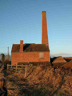
The Westonzoyland Pumping Station Museum of Steam Power and Land Drainage is a small industrial heritage museum dedicated to steam powered machinery at Westonzoyland in the English county of Somerset. It is a Grade II* listed building.

Westhay Moor is a 513.7-hectare (1,269-acre) biological Site of Special Scientific Interest 2.5 kilometres (1.6 mi) north-east of Westhay village and 4 kilometres (2.5 mi) from Wedmore in Somerset, England, notified in 1971. Westhay Moor is also notified as part of the Somerset Levels and Moors Special Protection Area under the EU Birds Directive and as a Ramsar site, and a National Nature Reserve.

Meare is a village and civil parish 3 miles (4.8 km) north west of Glastonbury on the Somerset Levels, in the Mendip district of Somerset, England. The parish includes the village of Westhay.

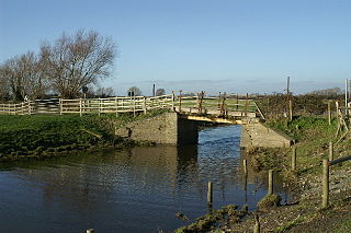
Galton's Canal was a 1-mile 3 furlong (2.2 km) canal with one lock, crossing Westhay Moor in Somerset, England, and connecting the River Brue to the North Drain. It was operational by 1822, and ceased to be used after the 1850s.
Meare Pool was a lake in the Somerset Levels in South West England. Lake villages existed there in prehistoric times. During medieval times it was an important fishery, but following extensive drainage works it had disappeared from maps in the eighteenth century.

The Abbot's Fish House in Meare, Somerset, England, was built in the 14th century and has been designated as a Grade I listed building and Scheduled Ancient Monument. It is the only surviving monastic fishery building in England.

The Tribunal in Glastonbury, Somerset, England, was built in the 15th century as a merchant's house. It has been designated as a Grade I listed building.

The Manor Farmhouse in Meare, Somerset, England, was built in the 14th century as the summer residence of the Abbots from Glastonbury Abbey and is now a farmhouse. Along with its outbuildings the farmhouse has been designated as a Grade I listed building.

The Whitelake River is a small river on the Somerset Levels, England.

Meare Lake Village is the site of an Iron Age settlement on the Somerset Levels at Meare, Somerset, England. It is a Scheduled Ancient Monument.

The Abbot's Kitchen is a mediaeval octagonal building that served as the kitchen at Glastonbury Abbey in Glastonbury, Somerset, England. It is a Grade I listed building. The abbot's kitchen has been described as "one of the best preserved medieval kitchens in Europe". The stone-built construction dates from the 14th century and is one of a very few surviving mediaeval kitchens in the world.

Beckery is an area within Glastonbury. It was once the main industrial area of the town. The area is said to have been visited by Saint Brigid of Kildare in the 4th or 5th century.
References
- 1 2 3 Gathercole, Clare (2003). An archaeological assessment of Glastonbury (PDF). English Heritage Extensive Urban Survey. Taunton: Somerset County Council. pp. 19–20.
- 1 2 Blair, John (2007). "Introduction". Waterways and Canal Building in Medieval England. Oxford, England: Oxford University Press. pp. 3–6. ISBN 978-0-19-921715-1.
- 1 2 3 4 Hollinrake, Charles; Hollinrake, Nancy (2007). "Glastonbury's Canal and Dunstan's Dyke". In Blair, John (ed.). Waterways and Canal Building in Medieval England. Oxford, England: Oxford University Press. pp. 235–239. ISBN 978-0-19-921715-1.
- ↑ Searle, Muriel (2002). West Country History: Somerset. Bristol, England: Intellect Books. p. 100. ISBN 978-1-84150-802-3.
- ↑ Rippon, Stephen (2004). "Making the Most of a Bad Situation? Glastonbury Abbey, Meare, and the Medieval Exploitation of Wetland Resources in the Somerset Levels" (PDF). Medieval Archaeology. 48: 93. doi:10.1179/007660904225022816. hdl: 10036/20952 . ISSN 0076-6097.
- ↑ Rippon (2004: 128)
- ↑ Recalled in Morland, John (1922). "The Brue at Glastonbury: Roman road, Pons Perilis, Beckery Mill". Proceedings. 68: 64–86.
...a canal still in existence under the northern side of Wyrral Hill to the Abbot's fish pond at Glastonbury