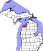
Leelanau County is a county located in the U.S. state of Michigan. As of the 2020 Census, the population was 22,301. Since 2008, the county seat has been located within Suttons Bay Township, one mile east of the unincorporated village of Lake Leelanau. Before 2008, Leelanau County's seat was Leland. Leelanau County is included in the Traverse City Micropolitan Statistical Area of Northern Michigan. The largest settlement in Leelanau County by population is Greilickville, itself a suburb of Traverse City.
Empire is a village on Lake Michigan in the northwestern Lower Peninsula of Michigan. Located in southwestern Leelanau County, its population was 362 at the 2020 census. The village is located within Empire Township, and is famous for its proximity to the Sleeping Bear Dunes National Lakeshore. Empire is home to the lakeshore's headquarters, the Philip A. Hart Visitor Center.

Empire Township is a civil township of Leelanau County in the U.S. state of Michigan. The population was 764 at the 2020 census. On the shores of Lake Michigan, Empire Township contains a substantial amount of land within the Sleeping Bear Dunes National Lakeshore.
Glen Arbor Township is a civil township of Leelanau County in the U.S. state of Michigan. The population was 757 at the 2020 census. However, the population of the town expands rapidly during the summer months as a result of it being a summer colony.

Leland Township is a civil township of Leelanau County in the U.S. state of Michigan. As of the early 2000s, the unincorporated community of Leland, which lies totally within the township, was the county seat of Leelanau County. However, county voters on August 3, 2004, approved a proposal to build a new governmental center in adjacent Suttons Bay Township; the move to the new facility was completed in 2008. As of the 2020 census, Leland Township population was 2,126.

Sleeping Bear Dunes National Lakeshore is a United States National Lakeshore located along the northwest coast of the Lower Peninsula of Michigan in Leelanau and Benzie counties near Empire, Michigan. The park covers a 35-mile-long (56 km) stretch of Lake Michigan's eastern coastline, as well as North and South Manitou islands. This Northern Michigan park was established primarily because of its outstanding natural features, including forests, beaches, dune formations, and ancient glacial phenomena. The lakeshore also contains many cultural features including the 1871 South Manitou Island Lighthouse, three former stations of the Coast Guard and an extensive rural historic farm district. In 2011, the area won the title of "The Most Beautiful Place in America" from Good Morning America. In 2014, a section of the park was named the Sleeping Bear Dunes Wilderness by the United States Congress.

North Manitou Island is located in Lake Michigan, approximately 12 miles (19 km) west-northwest of Leland, Michigan. It is nearly eight miles long and more than four miles (6 km) wide, with 20 miles (32 km) of shoreline. It has a land area of 57.876 km2 and has no population. The smaller South Manitou Island lies to its southwest.

South Manitou Island is located in Lake Michigan, approximately 16 miles (26 km) west of Leland, Michigan. It is part of Leelanau County and the Sleeping Bear Dunes National Lakeshore. The uninhabited island is 8.277 sq mi (21.44 km2) in land area and can be accessed by a ferry service from Leland. Guided tours on open-air vehicles are available to visitors, but most traffic is on foot. Larger North Manitou Island lies to its north.
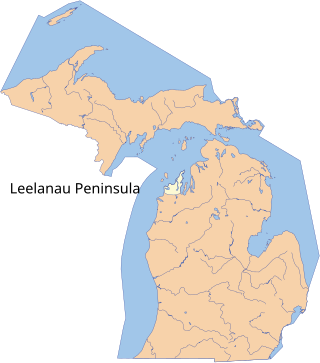
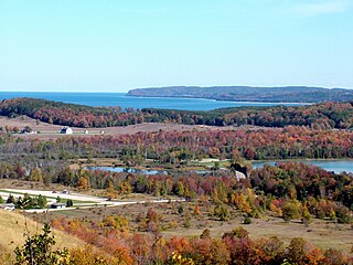
The Leelanau Peninsula is a peninsula of the U.S. state of Michigan that extends about 30 miles (50 km) from the western side of the Lower Peninsula of Michigan into Lake Michigan, forming Grand Traverse Bay. It is often referred to as the "little finger" of the mitten-shaped lower peninsula. The peninsula is a tourist hotspot, especially due to the popularity of Sleeping Bear Dunes National Lakeshore, which adorns the southwestern coast of the peninsula. The peninsula is also largely agricultural, and is a production hotspot for cherries and wine.

Leland is an unincorporated community and census-designated place (CDP) in the U.S. state of Michigan. It is located in Leelanau County, part of the northwestern Lower Peninsula of the state. As of the 2020 census it had a population of 410. From 1883 to 2004, Leland was the county seat of Leelanau County, which has since moved to Suttons Bay Township.

M-209 was a state trunkline highway in the Lower Peninsula of the US state of Michigan. It was located in Leelanau County in the Sleeping Bear Dunes National Lakeshore. Until it was decommissioned, it was Michigan's shortest state highway. M-209 started at M-109 and went just over 1⁄2 mile to Glen Haven. In 1995, M-209's designation was "abandoned", and the road was turned over to the jurisdiction of the Leelanau County Road Commission.

Glen Arbor is an unincorporated community and census-designated place in Glen Arbor Township, Leelanau County, Michigan, United States. A small tourist town, Glen Arbor lies on an isthmus between Lake Michigan and Glen Lake. It is adjacent to Sleeping Bear Dunes National Lakeshore.

Glen Lake is a lake located in Northern Michigan. Located in the southwestern Leelanau Peninsula, the lake is directly adjacent to Sleeping Bear Dunes National Lakeshore, and is, at its closest, about 0.94 miles (1.51 km) from Lake Michigan. The lake consists of two large bodies of water connected by a narrow channel, which is traversed by a causeway carrying the famous highway M-22. The body of water on the west of this causeway, which is far shallower and more elongated, is known as Little Glen Lake, and the body of water east of the causeway, which is nearly perfectly round and deeper, is known as Big Glen Lake.

M-109 is the designation of a state trunkline highway in the Lower Peninsula of the US state of Michigan that runs between Empire and Glen Arbor. The highway is a loop connected to M-22 at both ends that allows tourists access to Sleeping Bear Dunes National Lakeshore and the Pierce Stocking Scenic Drive located on a section of sandy forest land between Lake Michigan and Glen Lake. The trunkline traverses an area named the "Most Beautiful Place in America" by Good Morning America, the morning show on ABC. The highway was designated by 1929 and fully paved in 1939.
Point Betsie Light is located on the northeast shore of Lake Michigan — at the southern entrance to the Manitou Passage — north of Frankfort in Benzie County in Northern Michigan. Construction began in 1854, but it was not completed until 1858, and began service in the shipping season of 1859. The lighthouse cost $5,000 to build. In 1875, a life saving station was built for $3,000.

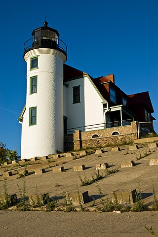
South Manitou Island Lighthouse is located on South Manitou Island in Lake Michigan, 16 miles (26 km) west of Leland, Michigan. It is in Leelanau County in western Northern Michigan.

North Manitou Island Lifesaving Station, also known as North Manitou Coast Guard Station, is a complex of buildings located on North Manitou Island, which is part of Sleeping Bear Dunes National Lakeshore in Michigan, in the U.S. The complex was constructed as a life-saving station. It is the only remaining station which was in use during all three periods of lifesaving service history, from the early volunteer period through operation by the United States Life-Saving Service and the United States Coast Guard. It was declared a National Historic Landmark in 1998.

The Pierce Stocking Scenic Drive is a scenic route within Sleeping Bear Dunes National Lakeshore, in western Northern Michigan in the United States. The roadway, with its "scenic vistas and gentle curves", is located off state highway M-109 between Empire and Glen Arbor. It runs for 7.4 miles (11.9 km) through forest and dunes areas, providing access to scenic overlooks of the Lake Michigan shoreline and the surrounding park land. Interpretive markers along the roadway are keyed to the National Park Service's printed guide to the drive. Over 80,000 vehicles make the trip, in addition to bicyclists, hikers and skiers who use the road each year.

The Sleeping Bear Point Life Saving Station, also known as the Glen Haven Coast Guard Station, is a Coast Guard station located near Glen Haven, Michigan. It is significant as a nearly intact version of what was, when built, a prototype architectural design. It was listed on the National Register of Historic Places in 1979, and is now the Sleeping Bear Point Coast Guard Station Maritime Museum and part of the Sleeping Bear Dunes National Lakeshore.

The Sleeping Bear Dunes National Lakeshore Conservation and Recreation Act is a law that designated as wilderness about 32,500 acres of the Sleeping Bear Dunes National Lakeshore in the state of Michigan. The newly designated lands and inland waterways comprise the Sleeping Bear Dunes Wilderness, a new component of the National Wilderness Preservation System.