North Manitou Island Lifesaving Station

Last updated
North Manitou Island Lifesaving Station
North Manitou Island Lifesaving Station - Michigan.png
Undated National Park Service photo
USA Michigan location map.svg
Red pog.svg
Usa edcp location map.svg
Red pog.svg
LocationEast Coast, North Manitou Island, Sleeping Bear Dunes National Lakeshore, Michigan
Coordinates 45°7′16″N85°58′39″W / 45.12111°N 85.97750°W / 45.12111; -85.97750 Coordinates: 45°7′16″N85°58′39″W / 45.12111°N 85.97750°W / 45.12111; -85.97750
Area3 acres (1.2 ha)
Built1854 (1854)
ArchitectFrancis W. Chandler, Albert B. Bibb
Architectural style Gothic Revival, Queen Anne, Stick/Eastlake
NRHP reference No. 98001191
Significant dates
Added to NRHPAugust 5, 1998 [1]
Designated NHLDAugust 6, 1998 [2]

North Manitou Island Lifesaving Station, also known as North Manitou Coast Guard Station, is a complex of buildings located on North Manitou Island, which is part of Sleeping Bear Dunes National Lakeshore in Michigan, in the U.S. The complex was constructed as a life-saving station. It is the only remaining station which was in use during all three periods of lifesaving service history, [3] from the early volunteer period through operation by the United States Life-Saving Service and the United States Coast Guard. [4] It was declared a National Historic Landmark in 1998. [2]

Contents

History

In 1854, the United States Congress allocated money to establish volunteer life-saving stations on the Great Lakes. [4] The North Manitou Island Lifesaving Station was established that same year. [3] Nicholas Pickard, a resident of North Manitou Island, requested and received from the government a lifesaving boat and the standardized plans to construct the station. [4] The boathouse on North Manitou Island is the only remaining boathouse constructed using the 1854 standard plans.

The United States Life-Saving Service was established in 1871, and the previously all-volunteer lifesaving stations were converted to house paid crews. [4] In 1874, they took over operation of the North Manitou Island station. [3] A new station was constructed in 1877, and a paid crew installed the following year. [4] The crew initially boarded with local residents, but in 1887 a crew quarters was built as part of the life-saving station. Additional structures were built at the station as needed. These included private homes, built by crew members; many of these were later moved to other locations on private lots.

The Life-Saving Service was merged into the United States Coast Guard in 1915, and the Coast Guard operated the station continuously until 1932, when it was determined that the station, lacking a protected boat launch, was no longer needed. [4] The station continued operation with a skeleton crew until 1938, [3] when it was sold to the Manitou Island Association, a private corporation. [4] The Association used the buildings to house employees, and for general operation of their island hunting preserve. The National Park Service acquired the station in 1984.

Description

Panorama of district US Lifesaving Station North Manitou Island Panorama.jpg
Panorama of district

The North Manitou Island Lifesaving Station is a complex of buildings located on 3 acres (1.2 ha) of land on the northeast shoreline of North Manitou Island. [3] The structures in the district date from 1854 to about 1916, and represent a range of historic architectural styles, as well as the three distinct periods of lifesaving history.

The Lifesaving Station is located on a broad flat plain facing a sandy beach, separated from structures in the nearby village by a grassy field. [4] An access road runs nearby. A number of structures were built at the station over time; some have been removed or demolished. Remaining structures in the district include:

Volunteer Rescue Station (1854)

1854 Volunteer Station US Lifesaving Station North Manitou Island Volunteer Station.jpg
1854 Volunteer Station

The Volunteer Rescue Station is a 1-1/2 story frame boathouse clad in cedar boards, approximately 17 feet (5.2 m) wide by 36 feet (11 m). [4] A single first-floor room was used to house the surfboat, and a small loft above was used for the storage of other equipment. The structure has been restored to its original appearance.

U.S. Life Boat Station (1877)

1877 Boathouse US Lifesaving Station North Manitou Island Boathouse.jpg
1877 Boathouse

The U.S. Life Boat Station was constructed using a modified version of the floor plan designed by Francis W. Chandler in 1876. [4] It is a two-story structure with a clipped gable end, providing shelter for a lookout balcony on one end. It is covered with vertical batten siding, with bracketry beneath the eaves. The Manitou Island Association converted the structure into a quarters and a storehouse, and the Sleeping Bear Dunes National Lakeshore adapted this boathouse into a dormitory in 1990.

U.S. Life-Saving Service Dwelling (1887)

1887 Crews Quarters US Lifesaving Station North Manitou Island Crews Quarters.jpg
1887 Crews Quarters

This dwelling, believed to have been developed by Life-Saving Service architect Albert B. Bibb, is believed to be the only one constructed of its type in the country. [4] It is a two-story structure with cross-gables, and originally housed the captain on the first floor and the crew on the second. In 1932, the Coast Guard renovated the structure, placing it on a basement, adding a front porch, and reworking the location of the stairs. In 1992, the Park Service adapted the building to house staff.

Hans Halseth House (1890s)

The Hans Halseth House was originally located some distance north of the station, and was moved to its current location in 1912. [4] The house is a 1-1/2 story side-gabled structure with a gabled dormer centered in the front. The house has been modified several times, including the addition of a hip roof front porch and two additions on the side. In 1990, the Park Service renovated and restored this building to house employees.

Crew Ready Room (1895)

The Crew Ready Room is a pyramidal hipped roof building where the on-duty crew would wait. [4] The building has lost much of its historical integrity, and is considered non-contributing to the historic district.

Root Cellar (1899)

The root cellar is primarily constructed of field stone and mortar, with a wood shingled gable roof on top. [4] Access into the cellar is an inclined double wooden cellar door at the surface, down a set of stairs, and through a second wooden door at the bottom of the stairs. The cellar has a round air vent on one side and a square screened hole on the other, providing air movement into the cellar.

Storm Tower and Flag Locker (c. 1905)

The storm tower is a four-sided metal-framed structure, made of open trusses with taper to a point 50 feet (15 m) above the ground. [4] A 20 feet (6.1 m) tall staff with sidearms projects above. The staff flew an American flag from the top, and storm flags from the yards. Flags were stored in a metal locker at the base of the tower.

Generator Building (1914-16)

The Generator Building is a small single story shed with gabled ends. [4] It has three windows and a single door.

Related Research Articles

North Manitou Island

North Manitou Island is located in Lake Michigan, approximately 12 miles (19 km) west-northwest of Leland, Michigan. It is nearly eight miles long and over four miles (6 km) wide, with 20 miles (32 km) of shoreline. It has a land area of 57.876 km2 and has no population. The smaller South Manitou Island lies to its southwest.

South Manitou Island Island in Leelanau County, Michigan, United States

South Manitou Island is located in Lake Michigan, approximately 16 miles (26 km) west of Leland, Michigan. It is part of Leelanau County and the Sleeping Bear Dunes National Lakeshore. The uninhabited island is 8.277 sq mi (21.44 km2) in land area and can be accessed by a ferry service from Leland. Guided tours on open-air vehicles are available to visitors, but most traffic is on foot. Larger North Manitou Island lies to its north.

Leland, Michigan Census-designated place & unincorporated community in Michigan, United States

Leland is an unincorporated community and census-designated place (CDP) in the U.S. state of Michigan. As of the 2010 census it had a population of 377. It was the county seat of Leelanau County from 1883 to 2008, when a new government center was completed in Suttons Bay Township, closer to the county's geographic center.

M-209 was a state trunkline highway in the Lower Peninsula of the US state of Michigan. It was located in Leelanau County in the Sleeping Bear Dunes National Lakeshore. Until it was decommissioned, it was Michigan's shortest state highway. M-209 started at M-109 and went just over ​12 mile to Glen Haven. In 1996, M-209's designation was "abandoned", and the road was turned over to the jurisdiction of the Leelanau County Road Commission.

United States Life-Saving Service Precursor to the U.S. Coast Guard

The United States Life-Saving Service was a United States government agency that grew out of private and local humanitarian efforts to save the lives of shipwrecked mariners and passengers. It began in 1848 and ultimately merged with the Revenue Cutter Service to form the United States Coast Guard in 1915.

Devils Island Light

The Devils Island Lighthouse is a lighthouse located on Devils Island, one of the Apostle Islands, in Lake Superior in Ashland County, Wisconsin, near the city of Bayfield.

Manitou Island Light Station

The Manitou Island Light Station is a lighthouse located on Manitou Island, off the tip of Michigan's Keweenaw Peninsula in Lake Superior. It was listed on the National Register of Historic Places in 1984.

Point Betsie Light

Point Betsie Light is located on the northeast shore of Lake Michigan — at the southern entrance to the Manitou Passage — north of Frankfort in Benzie County in Northern Michigan. Construction began in 1854, but it was not completed until 1858, and began service in the shipping season of 1859. The lighthouse cost $5,000 to build. In 1875, a life saving station was built for $3,000.

Point Reyes Lifeboat Station United States historic place

Point Reyes Lifeboat Station, also known as Point Reyes Lifeboat Rescue Station, is a historic coastal rescue station, located on the Drake's Bay side of Point Reyes in northern California, United States. It was built in 1927 by the United States Lifesaving Service to replace a previous station dating from 1888. It is one of the best-preserved rescue stations of that period on the Pacific coast, retaining elements often lost, including the boat launching infrastructure. It is now a historic property managed by the National Park Service as part of Point Reyes National Seashore. It was listed on the National Register of Historic Places in 1985, and it was further declared a National Historic Landmark in 1989.

Glen Haven, Michigan Unincorporated community in Michigan, United States

Glen Haven is a restored port village on the shore of Lake Michigan on the Leelanau Peninsula within the now Sleeping Bear Dunes National Lakeshore. Attractions include the Lake Michigan beach, a restored General Store and Blacksmith Shop. The unincorporated community is located in Glen Arbor Township.

Bodie Island Lifesaving and Coast Guard Station United States historic place

The Bodie Island Lifesaving Station, also known as the Bodie Island Coast Guard Station, is located on the Outer Banks of North Carolina at the southern end of Bodie Island, within Cape Hatteras National Seashore. The 10-acre (4.0 ha) district includes a residence, the lifesaving station, the Coast Guard station, and an observation tower, as well as a number of utility buildings. The facility was turned over to the National Park Service in 1953, with the establishment of the national seashore. The primary structure, the lifesaving station, was built in 1878, and was converted to a residence when the Coast Guard station was built in 1925. It was moved to its present location in 1955, as it was threatened by shoreline erosion. The Coast Guard station was altered the same year to provide housing and office space for the National Park Service.

Damariscove Lifesaving Station United States historic place

The Damariscove Lifesaving Station is a historic coastal maritime rescue facility, located on Damariscove Island in Boothbay, Maine. The station was built in 1897, and is one of the more architecturally distinguished of the surviving stations. It was listed on the National Register of Historic Places on June 25, 1987. It is now privately owned.

West Quoddy Lifesaving Station United States historic place

West Quoddy Lifesaving Station is a historic coastal rescue station on West Quoddy Head in Lubec, Maine. The lifesaving station was built in 1919, and was operated by the United States Coast Guard until 1972. It was listed on the National Register of Historic Places on April 20, 1990. It now houses a bed and breakfast inn.

Eagle Harbor Coast Guard Station Boathouse United States historic place

The Eagle Harbor Coast Guard Station Boathouse is a boathouse located at 9282 Marina Road in Eagle Harbor, Michigan. It was listed on the National Register of Historic Places in 2012.

North Manitou Shoal Light Station

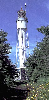
The North Manitou Shoal Light, also known as the North Manitou Light or, locally, The Crib, is a lighthouse located in Lake Michigan, southeast of North Manitou Island in Leland Township, Michigan. When it was automated in 1980, it was the last manned offshore light in the Great Lakes. It was listed on the National Register of Historic Places in 2005.

Sleeping Bear Point Life Saving Station United States historic place

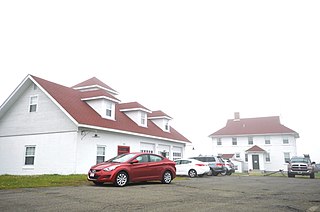
The Sleeping Bear Point Life Saving Station, also known as the Glen Haven Coast Guard Station, is a Coast Guard station located near Glen Haven, Michigan. It is significant as a nearly intact version of what was, when built, a prototype architectural design. It was listed on the National Register of Historic Places in 1979, and is now the Sleeping Bear Point Coast Guard Station Maritime Museum and part of the Sleeping Bear Dunes National Lakeshore.

Oregon Inlet Station United States historic place

Oregon Inlet Station is a historic lifesaving station located near Rodanthe, Dare County, North Carolina. It was built in 1897 by the United States Life-Saving Service and remodeled in 1933 and 1970. It is a 1 1/2-story, Shingle Style rectangular frame building with a lookout tower. It has a porch that surrounds the building. It was one of seven lifesaving stations established on the Outer Banks of North Carolina in 1874, to serve the ships that were lost in the treacherous waters off the North Carolina coast.

Whitehead Lifesaving Station United States historic place

The Whitehead Lifesaving Station was a maritime rescue facility on Whitehead Island, an island off the coast of St. George, Maine at the mouth of Penobscot Bay. Established in 1874 by the United States Life-Saving Service, its original building is one of the best-preserved of the five stations built by the service on the coast of Maine and New Hampshire at that time. The station was in active use until the 1940s, and is now privately owned. It was listed on the National Register of Historic Places in 1988.

Ocean City Life-Saving Station (New Jersey) United States historic place

The Ocean City Life-Saving Station is the only life-saving station of its design in New Jersey still in existence. Designed by architect James Lake Parkinson in a Carpenter Gothic style, the building is one of 25 stations built of the 1882 life-saving type. It is also one of six still in existence in the country. Construction on the facility began in September 1885 and was completed in the following year. There were two earlier stations in the northern end of Ocean City before this facility was constructed, and there were two stations farther south on the island.

References

  1. "National Register Information System". National Register of Historic Places . National Park Service. January 23, 2007.
  2. 1 2 "North Manitou Island Lifesaving Station". National Historic Landmark summary listing. National Park Service. Archived from the original on 2011-06-06. Retrieved 2008-05-03.
  3. 1 2 3 4 5 "North Manitou Island Life-Saving Station". Michigan State Housing Development Authority: Historic Sites Online. Retrieved January 25, 2014.
  4. 1 2 3 4 5 6 7 8 9 10 11 12 13 14 15 16 William Herd; Kimberly Mann; Candace Clifford; Patricia Henry (January 26, 1994). "National Historic Landmark Nomination: North Manitou Island Lifesaving Station / North Manitou Coast Guard Station". National Park Service.Cite journal requires |journal= (help) and Accompanying eight photos, from 1893, 1897, c.1916, 1996  (32 KB)