
Glen Allen is a census-designated place (CDP) in Henrico County, Virginia, United States. The population was 16,187 as of the 2020 Census, up from 14,774 at the 2010 census. Areas outside the CDP which use a "Glen Allen" mailing address include residences in neighboring Hanover County.

Glen Dale is a city in Marshall County, West Virginia, United States, along the Ohio River. It is part of the Wheeling, West Virginia Metropolitan Statistical Area. The population was 1,514 at the 2020 census. Glen Dale was incorporated in 1924. It is in the northwest part of the county, which is above the Mason–Dixon line and forms the base of the Northern Panhandle of West Virginia.

Princeton, is a city in and the county seat of Mercer County, West Virginia, United States. The city is coined the "Heart of Mercer County" or the "Jewel of the South" in past decades. The population was 6,432 at the 2010 census with approximately 35,000 residents living in the greater Princeton area. It is part of the Bluefield, WV-VA micropolitan area which has a population of 107,342. The city hosts the Princeton WhistlePigs baseball club of the Appalachian League. A main tourist destination of the city is the Mercer Street Grassroots District located in Downtown Princeton. This area has been revitalized and is now home to cafes, restaurants, shops, and artistic venues.

Pineville is a town in and the county seat of Wyoming County, West Virginia, United States, situated along the Guyandotte River. The population was 648 at the 2020 census.

The Virginian Railway was a Class I railroad located in Virginia and West Virginia in the United States. The VGN was created to transport high quality "smokeless" bituminous coal from southern West Virginia to port at Hampton Roads.

Charles Pratt was an American businessman. Pratt was a pioneer of the U.S. petroleum industry, and he established his kerosene refinery Astral Oil Works in Brooklyn, New York. He then lived with his growing family in Clinton Hill, Brooklyn. He recruited Henry H. Rogers into his business, forming Charles Pratt and Company in 1867. Seven years later, Pratt and Rogers agreed to join John D. Rockefeller's Standard Oil.

William Nelson Page was an American civil engineer and industrialist. He was active in the Virginias following the U.S. Civil War. Page was widely known as a metallurgical expert by other industry leaders and investors as well as state and federal authorities.
Page is a census-designated place (CDP) and coal town in Fayette County, West Virginia, United States. As of the 2010 census, its population was 224. It was named for William Nelson Page (1854-1932), a civil engineer and industrialist who lived in nearby Ansted, where he managed Gauley Mountain Coal Company and many iron, coal, and railroad enterprises.

State Route 207 is a primary state highway in the U.S. state of Virginia. Known for most of its length as Rogers Clark Boulevard, the state highway runs 11.93 miles (19.20 km) from U.S. Route 1 in Ruther Glen east to US 301 and SR 2 in Bowling Green. SR 207 is a divided highway connection between Interstate 95 (I-95) north of Richmond and US 301, which heads toward Fort A.P. Hill, the Northern Neck, and the Potomac River Bridge to Southern Maryland.
Glen Jean is a census-designated place (CDP) in Fayette County, West Virginia, United States, near Oak Hill. As of the 2010 census, its population is 210.
Westside High School is a consolidated regional high school in Clear Fork, West Virginia serving the western half of Wyoming County, West Virginia. It opened in 2002 and consolidated the former Oceana High School and Baileysville High School, also taking in about one-third of the attendance area of the former Glen Rogers High School, which had been merged into Oceana several years earlier.
Wyoming East High School is a consolidated regional high school in New Richmond, West Virginia serving the eastern half of Wyoming County, West Virginia. It opened in 1998 and consolidated the former Pineville High School and Mullens High School, also taking in the former Herndon High School and about two-thirds of the attendance area of the former Glen Rogers High School, both of which had been closed several years earlier. It also celebrates the academic and athletic heritage of Conley High School, which was the county's segregated school and had closed in 1964.

The Pennsylvanian Allegheny Formation is a mapped bedrock unit in western and central Pennsylvania, western Maryland and West Virginia, and southeastern Ohio. It is a major coal-bearing unit in the Appalachian Plateau of the eastern United States and fossils of fishes such as Bandringa are known from the Kittaning Formation, which is part of the Allegheny Group.
Pineville High School was a high school located in Wyoming County, West Virginia. It was closed in 1998 after consolidation with nearby Mullens High School to form Wyoming East High School.
Glen Rogers High School was a high school in Glen Rogers, Wyoming County, West Virginia. It was closed in 1992 and consolidated into nearby Pineville High School and Oceana High School.

Glen Daniel is an unincorporated community in Raleigh County, West Virginia, United States. Glen Daniel is located at the junction of West Virginia Route 3 and West Virginia Route 99, 8.5 miles (13.7 km) west of Beckley. Glen Daniel has a post office with ZIP code 25844.
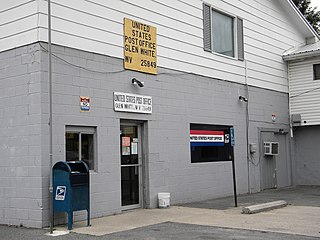
Glen White is a census-designated place (CDP) in Raleigh County, West Virginia, United States. Glen White is located on state routes 54 and 97, 1 mile (1.6 km) southeast of Lester. Glen White had a post office with ZIP code 25849. As of the 2010 census, its population is 266.
Glen Rogers may refer to:
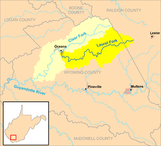
The Laurel Fork is a tributary of the Clear Fork, 23.5 miles (37.8 km) long, in southern West Virginia in the United States. Via the Clear Fork and the Guyandotte and Ohio rivers, it is part of the watershed of the Mississippi River, draining an area of 56.4 square miles (146 km2) in a rural area on the unglaciated portion of the Allegheny Plateau.
The Princeton–Deepwater District is a rail line in West Virginia that connects Deep Water, West Virginia, on the Kanawha River southwards to Princeton, West Virginia, and beyond to rail lines leading to Virginia. It is known for its rugged terrain and opportunities for rail photography.


