
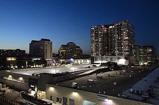
Ballston is a neighborhood in Arlington County, Virginia. Ballston is located at the western end of the Rosslyn-Ballston corridor. It is a major transportation hub and has one of the nation's highest concentrations of scientific research institutes and research and development agencies, including DARPA, the Office of Naval Research, the Advanced Research Institute of Virginia Tech, the Air Force Research Laboratory, and engineering, management, and public sector consulting firms. Ballston also includes a section known as Virginia Square and sometimes the area is collectively known as Ballston-Virginia Square.

Washington, D.C.'s Chinatown is a small, historic area of Downtown Washington, D.C. along H and I Streets between 5th and 8th Streets, Northwest. The area was once home to thousands of Chinese immigrants, but fewer than 300 remained in 2017. The current neighborhood was the second in Washington to be called “Chinatown” since 1931. Originally, the first Chinatown was built in the Federal Triangle on the south side of Pennsylvania Avenue some time after 1851, but was moved to the H Street area when a new federal building was built there. In 1986, a Chinese gate was built over H Street at 7th Street. By 1997, prominent landmarks such as the Capital One Arena, a sports and entertainment arena, occupied the area. The neighborhood is served by the Gallery Place station of the Washington Metro.

Clarendon is an urbanized, developed neighborhood in Arlington County, Virginia, located between the Rosslyn area and the Ballston area. It was named after Edward Hyde, 1st Earl of Clarendon, a leading statesman and historian of the English Civil War. The main thoroughfares are Wilson Boulevard and Clarendon Boulevard.
Pentagon City is an unincorporated neighborhood located in the southeast portion of Arlington County, Virginia. It is located near The Pentagon and Arlington National Cemetery.

The Washington and Old Dominion Railroad Regional Park is a linear regional park in Northern Virginia. The park's primary feature is the Washington and Old Dominion Railroad Trail, an asphalt-surfaced paved rail trail that runs through densely populated urban and suburban communities as well as through rural areas. Most of the trail travels on top of the rail bed of the former Washington and Old Dominion Railroad, which closed in 1968.

Kensington is a neighborhood in Philadelphia that belongs to Lower Northeast. As with all neighborhoods in the city, the lack of any official designation means the boundaries of the area vary between sources over time and are disputed among locals. Kensington, as most long-term residents view it, refers generally to the area consisting of Kensington, East Kensington, West Kensington, and Harrowgate. The adjacent Fairhill and Norris Square neighborhoods are more separate but may be included in Kensington; Fishtown and South (Olde) Kensington were historically included. The most conservative boundaries of the neighborhood, shown in the map below, are Front Street and 5th Street to the west, the Amtrak train tracks to the North, Trenton Avenue, the Trenton Avenue train tracks, and Frankford Avenue to the east, and Cecil B. Moore Avenue to the south.
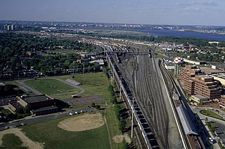
Potomac Yard is a neighborhood in Northern Virginia that straddles southeastern Arlington County and northeastern Alexandria, Virginia, located principally in the area between U.S. Route 1 and the Washington Metro Blue Line /Yellow Line tracks, or the George Washington Memorial Parkway, depending on the definition used. The area was home to what was once one of the busiest rail yards on the Eastern Seaboard of the United States. The "Potomac Yard" name is also used to refer to several developments in the area, especially the Potomac Yard Center power center and a Washington Metro station.

Four Mile Run is a 9.4-mile-long (15.1 km) stream in Northern Virginia that starts near Interstate 66, at Gordon Avenue in Fairfax County and proceeds southeast through Falls Church to Arlington County in the U.S. state of Virginia. Most of the stretch is parkland and is paralleled by two paved non-motorized transport and recreational trails, the Washington and Old Dominion Railroad Trail and the Four Mile Run Trail.

Fairlington is an unincorporated neighborhood in Arlington County, Virginia, located adjacent to Shirlington in the southernmost part of the county on the boundary with the City of Alexandria. The main thoroughfares are Interstate 395, which divides the neighborhood into North and South Fairlington, State Route 7 and State Route 402.

The Northern Virginia trolleys were the network of electric streetcars that moved people around the Northern Virginia suburbs of Washington, D.C., from 1892 to 1941. They consisted of six lines operated by as many as three separate companies connecting Rosslyn, Great Falls, Bluemont, Mount Vernon, Fairfax, Camp Humphries, and Nauck across the Potomac River to Washington, D.C.

The boundary markers of the original District of Columbia are the 40 milestones that marked the four lines forming the boundaries between the states of Maryland and Virginia and the square of 100 square miles (259 km2) of federal territory that became the District of Columbia in 1801. Working under the supervision of three commissioners that President George Washington had appointed in 1790 in accordance with the federal Residence Act, a surveying team led by Major Andrew Ellicott placed these markers in 1791 and 1792. Among Ellicott's assistants were his brothers Joseph and Benjamin Ellicott, Isaac Roberdeau, George Fenwick, Isaac Briggs and an African American astronomer, Benjamin Banneker.
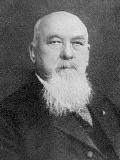
Samuel Swinfin Burdett was a U.S. Representative from Missouri.

The Pennsylvania School for the Deaf is the third-oldest school of its kind in the United States. Its founder, David G. Seixas (1788–1864), was a Philadelphia crockery maker-dealer who became concerned with the plight of impoverished deaf children who he observed on the city's streets. The current school building is listed by the National Register of Historic Places, and two former campuses are similarly recognized.

The Ball–Sellers House, also named the John Ball House, is the oldest building in Arlington County, Virginia. It is an historic home located at 5620 Third Street, South, in the county's Glencarlyn neighborhood. The Arlington Historical Society, which owns the building, estimates that the one room log cabin was built in the 1740s.

Carlin Hall, also known as Curtis Hall, Carlin Community Hall, Glencarlyn School, Glencarlyn Recreation Center, is a historic community center located in the Glencarlyn section of Arlington, Virginia, US. It was built in 1892, and is a tall one-story, frame, Late Victorian cross-plan community hall. It measures approximately 45 feet wide and 30 feet deep. The standing seam metal gable roof is topped by a four-sided wood cupola. It originally served as a meeting place for the newly formed Glencarlyn civic association and the Episcopal church congregation, provided a place for a variety of community social events. The building housed an elementary school from the 1920s to 1950. In 1953, it was returned by Arlington County as a community center.

The Glencarlyn Historic District is a national historic district located in the Glencarlyn neighborhood of Arlington County, Virginia. It contains 276 contributing buildings, two contributing sites, one contributing structure, and one contributing object in a residential neighborhood in South Arlington. The area was platted in 1887 as Carlin Springs and continued to develop throughout the 20th century as a residential subdivision. The dwelling styles include a variety of architectural styles, ranging from Craftsman-style bungalows, Colonial Revival–style, and Queen Anne style dwellings. Notable buildings and sites include the Carlin Family Cemetery, Glencarlyn Library, and St. John's Episcopal Church. Also located in the district are the separately listed Ball-Sellers House and Carlin Hall.
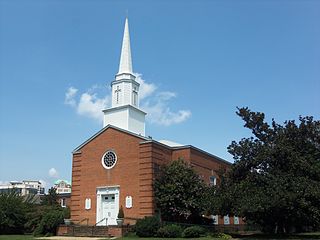
First Presbyterian Church of Arlington, Virginia, United States, is a congregation in the National Capital Presbytery, the Synod of Mid-Atlantic and the Presbyterian Church (USA).
Nauck is a neighborhood in the southern part of Arlington County, Virginia, known locally as Green Valley. It is bordered by Four Mile Run and Shirlington to the south, Douglas Park to the west, I-395 to the east, and Columbia Heights and the Army-Navy Country Club to the north. The southeastern corner of the neighborhood borders the City of Alexandria.

The Arlington Public Library is a public library system located in Arlington County, Virginia. The library system includes nine locations that serve 214,373 people.

North Philadelphia East is a neighborhood that is located in the eastern central part of North Philadelphia section of Philadelphia, Pennsylvania, United States.


