Crystal City, Virginia

Last updated

Crystal City, Arlington, Virginia
Crystal City, VA 2016.png
Aerial view of Crystal City (foreground) and the Potomac River and Washington, D.C. (background) in September 2020
Crystal City satellite image.jpg
Satellite image of Crystal City with U.S. Route 1 (left); Reagan National Airport (bottom right); George Washington Memorial Parkway (left); I-395 (top left), and The Pentagon, VA Route 233, and the Airport Viaduct (bottom) in 2002
Coordinates: 38°51′5.05″N77°3′2.48″W / 38.8514028°N 77.0506889°W / 38.8514028; -77.0506889
Country Flag of the United States.svg United States
State Flag of Virginia.svg  Virginia
County Flag of Arlington County, Virginia.svg Arlington
Population
 (2010)
  Total22,543
Time zone UTC−5 (EST)
  Summer (DST) UTC−4 (EDT)
ZIP Code
22202
Area codes 703, 571

Crystal City is an urban neighborhood in the southeastern corner of Arlington County, Virginia, approximately 5 miles south of Downtown Washington, D.C. Due to its extensive integration of office buildings and residential high-rise buildings using underground corridors, travel between stores, offices, and residences, it is possible to travel much of the neighborhood without going above ground, making at least part of Crystal City an underground city.

Contents

Crystal City includes several aerospace manufacturing and defense industry companies, public sector consulting firms, government contractors, the U.S. Department of Labor, the U.S. Department of Labor, satellite offices for the Pentagon, and various nonprofit organizations, including the International Foundation for Electoral Systems and the national headquarters for PBS.

Ronald Reagan Washington National Airport, the busiest airport in the Washington metropolitan area and 23rd-busiest airport in the nation with 11,553,850 passengers as of 2022, is located in Crystal City.

Cityscape

Crystal City is centered along a stretch of U.S. Route 1, also known as Richmond Highway, just south of the Pentagon, east of Pentagon City, and within walking distance of Ronald Reagan Washington National Airport, the busiest of the three major airports in the Washington metropolitan area. Characterized as one of several urban villages by Arlington County, Crystal City is almost exclusively populated by high-rise apartment buildings, corporate offices, hotels, and numerous shops and restaurants. There is also an extensive network of underground shopping areas and connecting corridors beneath Crystal City.

Crystal City has a station on the Washington Metro's Blue and Yellow Lines, and another on the Virginia Railway Express commuter train system.

Crystal City's layout was considered avant-garde at the time of construction in 1963 with superblocks bounded by arterial and circulating roads and pedestrian traffic and the businesses serving it relocated from the streets to pedestrian tunnels. Crystal City has since been redesigned to give it a more traditional, urban feel, with restaurants at street level, and with traffic patterns changed to make major streets like Crystal Drive function as city street, rather than as circulating roads. [1]

History

20th century

An aerial view of Crystal City (foreground) with I-395 crossing the Potomac River and the Jefferson Memorial and Washington Monument (background) in the 1980s Crystal City 80's.jpg
An aerial view of Crystal City (foreground) with I-395 crossing the Potomac River and the Jefferson Memorial and Washington Monument (background) in the 1980s
Crystal City looking north in January 2020 CrystalCity-2134 012120.jpg
Crystal City looking north in January 2020

Before Crystal City's development by the Charles E. Smith Company, the area was underutilized with light industrial activity and motels next to National Airport before the age of more consistent business travel. A drive-in theater existed at the intersection of Jefferson Davis Highway and 20th Street South between 1947 and 1963 is visible on aerial photos from this period. Tracks from the Richmond, Fredericksburg and Potomac Railroad were moved closer to National Airport to provide additional room for development.

Though it is not a planned community, Crystal City unfolded in much that fashion after construction began on the first few condominiums and office buildings in 1963. The name "Crystal City" came from the first building, which was called Crystal House and had an elaborate crystal chandelier in the lobby. Every subsequent building initially took on the Crystal name, including Crystal Gateway and Crystal Towers, and others. Crystal City is largely integrated in layout with extensive landscaping with most of its high-rise buildings featuring speckled granite exteriors.

Crystal City's Crystal Underground shopping mall opened in September 1976. Billed as a "turn-of-the-century shopping village," it featured antique leaded glass shop windows and cobblestone "streets". [2] Emphasis was on locally owned and operated businesses and personalized service. The largest retail outlets were a 12,000-square-foot (1,100 m2) Jelleff's women's store, Larimers gourmet grocery and delicatessen, and a Drug Fair. The mall also featured an Antique Alley with small antique and craft stores. At its opening in 1976, there were 40 stores and anticipated expansion of 150,000 square feet (14,000 m2) with 70 more shops, including the Crystal Palace food court. [3]

21st century

Beginning in June 2004, the Crystal City area underwent a number of changes. Many buildings' addresses were changed on this date, several major roads were turned into two-way streets, and many of the markings for the traditional building names, including Crystal Gateway 1, were removed. As a result, local residents often refer to building names that are difficult for visitors to find. [4]

In 2010, Arlington County developed the Crystal City Sector Plan, which presented the community's vision to transform Crystal City into a more inviting, lively, and walkable community with more ground-floor retail, better quality office space, and more housing options. [5] This 40-year plan, which won the American Planning Association’s 2013 National Planning Achievement Award for Innovation in Economic Planning and Development, was credited with pioneering the use economic analysis for planning purposes and closely studying the economic impact of demolishing and replacing major commercial buildings.

Economy

Crystal City currently has over 22,000 residents, while around 60,000 come to work there every weekday. [6]

Crystal City is home to the headquarters of the U.S. Marshals Service and several Department of Defense offices. It also has offices of the General Services Administration and satellite offices for the Pentagon, many of which were built or occupied during the Pentagon Renovation Program. [7] Pentagon offices in Crystal City include the headquarters of the Warrior Transition Command and the Special Inspector General for Afghanistan Reconstruction.

US Airways once maintained its headquarters in the Crystal Park Four building in Crystal City. [8] After US Airways merged with America West Airlines in 2005, the combined company closed the Virginia headquarters and moved the management to Tempe, Arizona, in Greater Phoenix. [9]

Several companies, associations, and organizations are headquartered in Crystal City, including Boeing, [10] Bloomberg Industry Group, the American Diabetes Association, [11] PBS, the American Public Power Association, [12] and the Consumer Technology Association, [13] and others.

Amazon HQ2

On November 13, 2018, Amazon.com announced that Crystal City would be the location of one of two campuses for its Amazon HQ2; the other campus will be located in Long Island City in Queens, New York City. Both campuses are expected to employ approximately 25,000 workers. [14] [15] [16] [17]

In Amazon's announcement with Northern Virginia bidders, it announced that its HQ2 neighborhood location would be jointly marketed as "National Landing", which encompasses Crystal City and part of Pentagon City and Potomac Yard. [18] In February 2019, Amazon decided to cancel its plans for the Queens location for HQ2 and instead focus exclusively on the Crystal City location, and construction for it is ongoing.

Related Research Articles

<span class="mw-page-title-main">Arlington County, Virginia</span> County in Virginia, United States

Arlington County, or simply Arlington, is a county in the U.S. state of Virginia. The county is located in Northern Virginia on the southwestern bank of the Potomac River directly across from Washington, D.C., the national capital.

<span class="mw-page-title-main">Ronald Reagan Washington National Airport</span> Airport in Arlington, Virginia, serving Washington, D.C., U.S.

Ronald Reagan Washington National Airport is a civil airport located in Crystal City, Virginia, in Arlington County, Virginia, 5 miles (8.0 km) from Washington, D.C. It is the closest airport to Washington, D.C., the nation's capital, the 23rd-busiest airport in the nation, and the busiest airport in both the Washington metropolitan area and the Washington–Baltimore combined statistical area.

US Airways was an American airline that operated from 1937 until 2015, when it merged with American Airlines. It was originally founded in Pittsburgh as a mail delivery airline called All American Aviation, which soon became a commercial passenger airline. In 1953, it was renamed Allegheny Airlines and operated under that name for a quarter-century. In October 1979, after the passage of the Airline Deregulation Act, Allegheny Airlines changed its name to USAir. A decade later it had acquired Piedmont Airlines and Pacific Southwest Airlines (PSA), and was one of the U.S.'s seven transcontinental legacy carriers. In 1997, it rebranded as US Airways.

<span class="mw-page-title-main">Fashion Centre at Pentagon City</span> Shopping mall in Virginia, United States

Fashion Centre at Pentagon City, originally the Pentagon City Mall, is an enclosed shopping mall in the Pentagon City neighborhood of Arlington, Virginia, near Interstate 395 and Hayes Street. Its Metro level is directly connected to the Pentagon City station on the Blue and Yellow Lines of the Washington Metro. The mall features Macy's and Nordstrom, and also houses the Ritz-Carlton Pentagon City hotel.

<span class="mw-page-title-main">Crystal City station (Washington Metro)</span> Washington Metro station

Crystal City station is an underground Washington Metro station in the Crystal City neighborhood of Arlington County, Virginia. The station opened on July 1, 1977, and serves the Blue Line and Yellow Line services, with a Metroway bus rapid transit stop on the surface.

<span class="mw-page-title-main">Rosslyn station</span> Washington Metro station

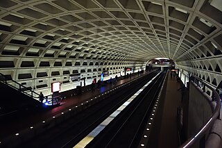
Rosslyn station is the westernmost station on the shared segment of the Blue, Orange, and Silver lines of the Washington Metro. It is located in the Rosslyn neighborhood of Arlington County, Virginia. Rosslyn is the first station in Virginia heading westward from Washington, D.C. on the Orange and Silver Lines and southward on the Blue Line. It is one of four interchange points on the Metrorail system west of the Potomac River and located in a growing business district.

<span class="mw-page-title-main">Farragut West station</span> Washington Metro station

Farragut West station is a Washington Metro station in Downtown Washington, D.C., United States. The side-platformed station was opened on July 1, 1977, and is operated by the Washington Metropolitan Area Transit Authority (WMATA). Providing service for the Blue, Orange and Silver Lines, the station is located just west of Farragut Square with two entrances on I Street at 17th and 18th Streets NW.

<span class="mw-page-title-main">Pentagon City</span> Area of Arlington County, Virginia, US

Pentagon City is an unincorporated neighborhood located in the southeast portion of Arlington County, Virginia. It is located near The Pentagon and Arlington National Cemetery.

<span class="mw-page-title-main">Virginia State Route 110</span> State highway in Arlington County, Virginia, United States

Virginia State Route 110 (SR 110) is a primary state highway in Arlington, Virginia. Known as the Richmond Highway, the state highway runs 2.41 miles (3.88 km) from U.S. Route 1 (US 1) and Interstate 395 (I-395) in Crystal City north to I-66 in the Rosslyn neighborhood. SR 110 is a four- to six-lane freeway that parallels the Potomac River, providing a connection between several of Arlington's urban villages and major landmarks, including the Pentagon, which is the headquarters of the United States Department of Defense, and the grounds of Arlington National Cemetery. The highway also provides access to SR 27, an east–west freeway between the Pentagon and the cemetery, and the George Washington Parkway that parallels the Potomac River. SR 110 is a part of the National Highway System for its entire length.

<span class="mw-page-title-main">Potomac Yard</span> Neighborhood in Northern Virginia

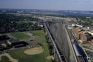
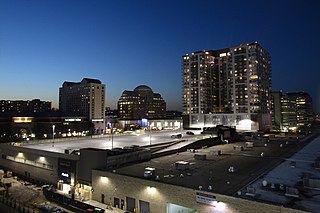
Potomac Yard is a neighborhood in Northern Virginia that straddles southeastern Arlington County and northeastern Alexandria, Virginia, located principally in the area between U.S. Route 1 and the Washington Metro Blue Line /Yellow Line tracks, or the George Washington Memorial Parkway, depending on the definition usedF. The area was home to what was once one of the busiest rail yards on the Eastern Seaboard of the United States. The "Potomac Yard" name is also used to refer to several developments in the area, especially the Potomac Yard Center power center and a Washington Metro station.

<span class="mw-page-title-main">Economy of Virginia</span>

The economy of the Commonwealth of Virginia is well balanced with diverse sources of income. From the Hampton Roads area to Richmond and down to Lee County in the southwest includes military installations, cattle, tobacco and peanut farming in Southside Virginia. Tomatoes recently surpassed soy as the most profitable crop in Virginia. Tobacco, peanuts and hay are also important agricultural products from the commonwealth. Wineries and vineyards in the Northern Neck and along the Blue Ridge Mountains also have become increasingly popular. Northern Virginia hosts software, communications, consulting, defense contracting, diplomats, and considerable components of the professional government sector. As of the 2000 census, Virginia had the highest number of counties and independent cities (15) in the top 100 wealthiest jurisdictions in the United States based upon median income, in addition, Virginia tied with Colorado as having the most counties (10) in the top 100 based on per capita income. Loudoun and Fairfax counties in Northern Virginia have the highest and second highest median household income, respectively, of all counties in the United States as of 2017.

<span class="mw-page-title-main">Pentagon Row</span> Shopping mall in Virginia, United States

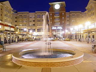
Westpost at National Landing is an upscale outdoor shopping and residential center in Arlington, Virginia, United States with storefronts facing South Joyce Street. It is adjacent to the Fashion Centre at Pentagon City. Formerly known as Pentagon Row, in December 2020 it changed its name to "Westpost at National Landing" to better align with the neighborhood as it evolved following the announcement of Amazon's HQ2.

<span class="mw-page-title-main">The Pentagon</span> Headquarters of the US Department of Defense in Arlington, Virginia

The Pentagon is the headquarters building of the United States Department of Defense, in Arlington County, Virginia, across the Potomac River from Washington, D.C. The building was constructed on an accelerated schedule during World War II. As a symbol of the U.S. military, the phrase The Pentagon is often used as a metonym for the Department of Defense and its leadership.

<span class="mw-page-title-main">Metroway</span> Bus rapid transit line operated by the Washington Metropolitan Area Transit Authority

Metroway is a bus rapid transit (BRT) line operated by the Washington Metropolitan Area Transit Authority (WMATA) as part of their Metrobus system. It consists of a single line operating in Arlington and Alexandria, Virginia. It opened on August 24, 2014. It was the first bus rapid transit line to open in Virginia and in the Washington metropolitan area.

<span class="mw-page-title-main">Amazon HQ2</span> Amazon.coms future second headquarters in North America

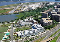
Amazon HQ2 is Amazon's corporate headquarters in National Landing in Crystal City, Virginia and an expansion of the company's headquarters in Seattle, Washington. Phase I, which has capacity for 14,000 employees, opened in June 2023. Construction on Phase II is delayed and there is no timeline for development.

<span class="mw-page-title-main">History of Amazon</span>

Amazon is an American multinational technology company which focuses on e-commerce, cloud computing, and digital streaming. It has been referred to as "one of the most influential economic and cultural forces in the world", and is one of the world's most valuable brands.

<span class="mw-page-title-main">National Landing</span> Area in Northern Virginia

National Landing is an area in Northern Virginia encompassing parts of the Crystal City and Pentagon City neighborhoods of Arlington County and the Potomac Yard neighborhood in the city of Alexandria. It is the location of the Amazon HQ2 headquarters.

<span class="mw-page-title-main">Columbia Pike–National Landing Line</span> Bus route

The Columbia Pike–National Landing Line, designated as Route 16M, is a daily bus route operated by the Washington Metropolitan Area Transit Authority between Skyline City and Crystal City station of the Yellow and Blue lines of the Washington Metro. This line is part of the Pike Ride service, which runs through Columbia Pike. This line provides service through the neighborhoods of Fairfax County and Arlington County to Crystal City. Unlike the Columbia Pike Line, the Columbia Pike–National Landing Line does not serve Columbia Pike past the Arlington County line.

<span class="mw-page-title-main">Economy of the Washington metropolitan area</span>

The economy of the Washington metropolitan area includes the economy of Washington, D.C., and its suburbs, including parts of Maryland, all of Northern Virginia, and Jefferson County, West Virginia. In 2022, the DC metro area had the country's fifth-highest gross metropolitan product, at $541 billion. The region's economy is highly diverse and includes the principal industries of the US federal government, tourism, information technology, research, hospitality, news media, and bioscience.

References

  1. "Envisioning Crystal City as part of a larger community". Greater Greater Washington. May 14, 2009. Archived from the original on June 12, 2010. Retrieved October 26, 2009.
  2. Warburton, Jena (May 1, 2024). "Popular mall shuttering all stores for surprising reason". TheStreet. Retrieved May 4, 2024.
  3. "Crystal Underground opens," by Pat Royse, The Washington Post, Sep 30, 1976, p. VA_14.
  4. David A. Wheeler. "Crystal City Name Changes (Address Changes)". Archived from the original on October 19, 2010. Retrieved November 1, 2010.
  5. "Crystal City Sector Plan" (PDF). Arlington County, Virginia. 2010. Archived (PDF) from the original on April 22, 2020.
  6. Linda Wheeler (March 25, 1995). "Crystal City: Model of Convenience". The Washington Post. Retrieved October 26, 2009.
  7. E.L. Wasson (December 1, 2007). "Washington, D.C.: Threatened Crystal City closures appear derailed | The Real Deal | New York Real Estate News". Ny.therealdeal.com. Archived from the original on December 2, 2008. Retrieved July 16, 2009.
  8. "THE FOLLOWING LETTER WAS SENT TO THE ATTACHED LIST OF U.S. & FOREIGN AIRLINE, and TRAVEL AGENCY EXECUTIVES Archived 2013-02-18 at the Wayback Machine ." U.S. Department of Transportation . July 14, 1995. Retrieved on March 1, 2010.
  9. "US Airways to move headquarters to Tempe, Ariz., early in 2006." The Tribune. July 23, 2005. Retrieved on March 1, 2010.
  10. Hansen, Drew (February 21, 2023). "Boeing offers CEO Dave Calhoun more than $5M in additional stock awards to stay on". American City Business Journals.
  11. Daniel J. Sernovitz (January 20, 2015). "American Diabetes Association to shift headquarters from Alexandria to Crystal City". Washington Business Journal .
  12. "The PBS No Downtime Move" . Retrieved November 8, 2018.
  13. "CTA - home". CTA. Retrieved March 4, 2019.
  14. O'Connell, Jonathan; McCartney, Robert (November 5, 2018). "Amazon in advanced talks about putting HQ2 in Northern Virginia, those close to process say". The Washington Post.
  15. "Amazon Selects New York City and Northern Virginia for New Headquarters". Amazon. November 13, 2018. Retrieved November 13, 2018.
  16. Stevens, Laura; Morris, Keiko; Honan, Katie (November 13, 2018). "Amazon Picks New York City, Northern Virginia for Its HQ2 Locations". The Wall Street Journal. Retrieved November 13, 2018.
  17. "Amazon's Grand Search For 2nd Headquarters Ends With Split: NYC And D.C. Suburb". NPR. November 13, 2018. Retrieved November 13, 2018.
  18. "National Landing? Long Island City? This is where Amazon's headquarters are located". USA Today.

Further reading