Crystal City station (Washington Metro)

Last updated

Crystal City
WMATA Blue.svg WMATA Yellow.svg
Crystal City station, November 2010.jpg
Crystal City station in November 2010
General information
Location18th Street South and South Bell Street
Arlington, Virginia
Coordinates 38°51′28″N77°03′03″W / 38.857856°N 77.050874°W / 38.857856; -77.050874
Owned by Washington Metropolitan Area Transit Authority
Platforms2 side platforms
Tracks2
Connections
Construction
Structure typeUnderground
Bicycle facilities Capital Bikeshare, 10  racks
AccessibleYes
Other information
Station codeC09
History
OpenedJuly 1, 1977 (July 1, 1977)
Passengers
20234,013 daily [1]
Rank22 out of 98
Services
Preceding station WMATA Metro Logo small.svg Washington Metro Following station
National Airport Blue Line Pentagon City
National Airport
toward Huntington
Yellow Line Pentagon City
Preceding station Metroway Following station
18th & Crystal
One-way operation
Potomac Yard Pentagon City
Terminus
23rd & Clark
Location
Crystal City station (Washington Metro)

Crystal City station is an underground Washington Metro station in the Crystal City neighborhood of Arlington County, Virginia. The station opened on July 1, 1977, and serves the Blue Line and Yellow Line services, with a Metroway bus rapid transit stop on the surface.

Contents

Station layout

The station entrance in 2016 Crystal City Metro headhouse 2016.jpg
The station entrance in 2016

The station has two side platforms in a cylindrical vault, which runs east–west under plazas on the north side of 18th Street South between Jefferson Davis Highway and Crystal Drive. The fare mezzanine is located above the center of the platforms. The single station entrance is on the northwest corner of 18th Street South and South Bell Street, with a bank of escalators leading to an upper mezzanine. [2] :15

Located outside the station vault, the upper mezzanine has direct entrances to the underground Crystal City Shops. An elevator on the northeast corner of 18th Street South and South Bell Street connects directly to the lower mezzanine; each platform has one elevator from the mezzanine. Bus stops, including a Metroway stop served by both northbound and southbound buses, are located on South Bell Street under the 251 18th Street South building. [2] :15

History

Metrobus at the station in 2005 Metrobus 4233 at Crystal City (50094192108).jpg
Metrobus at the station in 2005

The station opened on July 1, 1977, part of the 11.8-mile (19.0 km) initial segment of the Blue Line between National Airport and Stadium–Armory stations that opened that day. [3] [4] [5]

Virginia Railway Express began service in June 1992, with its Crystal City station about 0.2 miles (0.32 km) northeast of the Metro entrance. [6] Metroway bus rapid transit service began on August 24, 2014, with a stop on Bell Street adjacent to the Metro entrance. [7]

Second entrance

An east entrance to the station was proposed in a 2002 WMATA study. [2] :1 Planning for the second entrance began in 2011. [2] :4 A 2014 study identified five possible locations for the new entrance, with locations on the northeast and northwest corners of 18th Street South and Crystal Drive preferred. [2] :53 In February 2019, the state committed to building the entrance as part of a package of transportation improvements for the construction of Amazon HQ2 in National Landing. [8]

In May 2019, property developer JBG Smith sent an unsolicited proposal, proposing that Arlington County pay the company to act as design-build contractor for the entrance on company-owned property. [9] The county and company signed a preliminary agreement in June 2020. [10] Design of the second entrance reached 30% in March 2021. [11]

In March 2022, plans were changed from an underground to a surface-level fare lobby to reduce costs. [12] In July 2023, the Arlington County Board awarded a $117 million design-build contract for the entrance to a joint venture of JBG Smith and Clark Construction. [13] [14]

Related Research Articles

<span class="mw-page-title-main">Foggy Bottom–GWU station</span> Washington Metro station

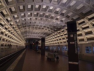
Foggy Bottom–GWU station is a Washington Metro station in the Foggy Bottom neighborhood of Washington, D.C., United States. The island-platformed station was opened on July 1, 1977, and is operated by the Washington Metropolitan Area Transit Authority (WMATA). Providing service for the Blue, Orange, and Silver Lines, the station is located on I Street on the George Washington University (GWU) campus. It is the last westbound station in the District of Columbia on these lines before they dive under the Potomac River to Virginia.

<span class="mw-page-title-main">Yellow Line (Washington Metro)</span> Washington Metro rapid transit line

The Yellow Line is a rapid transit line of the Washington Metro system that runs between Huntington in Virginia and Mount Vernon Square in Washington, D.C. It consists of 13 stations in Fairfax County, the city of Alexandria, and Arlington County in Virginia, and Washington, D.C. It is the shortest line in the system, and since its truncation to Mount Vernon Square, it is the only line that does not enter Maryland.

<span class="mw-page-title-main">Farragut North station</span> Washington Metro station

Farragut North station is an underground Washington Metro station in Washington, D.C., located on the Red Line. The station serves Downtown Washington and is immediately northwest of Farragut Square. With an average of 7,615 daily riders in 2023, Farragut North was the sixth-busiest stop in the system.

<span class="mw-page-title-main">Friendship Heights station</span> Washington Metro station

Friendship Heights station is a Washington Metro station on the Red Line straddling the border of Washington, D.C., and Montgomery County, Maryland, United States. The station was opened on August 25, 1984, and is operated by the Washington Metropolitan Area Transit Authority (WMATA).

<span class="mw-page-title-main">East Falls Church station</span> Washington Metro station

East Falls Church station is an island platformed Washington Metro station in Arlington County, Virginia, on the Orange and Silver Lines. East Falls Church station is the last aboveground, at-grade, or open-cut station for eastbound trains. East of this station, the trains enter tunnels.

<span class="mw-page-title-main">Ballston–MU station</span> Washington Metro station

Ballston–MU station is a side platformed Washington Metro station in Arlington County, Virginia. The station opened on December 1, 1979, and is operated by the Washington Metropolitan Area Transit Authority (WMATA). The station is part of the Orange and Silver Lines and serves the transit-oriented community of Ballston, Ballston Quarter, and Marymount University (MU).

<span class="mw-page-title-main">Clarendon station</span> Washington Metro station

Clarendon station is a side platformed Washington Metro station in the Clarendon neighborhood of Arlington, Virginia, United States. The station was opened on December 1, 1979, and is operated by the Washington Metropolitan Area Transit Authority (WMATA). The station serves the Orange and Silver Lines. In 2017, over 4,000 commuters used Clarendon station every day.

<span class="mw-page-title-main">Court House station</span> Washington Metro station

Court House station is an island platformed Washington Metro station in the Courthouse neighborhood of Arlington, Virginia, United States. The station was opened on December 1, 1979, and is operated by the Washington Metropolitan Area Transit Authority (WMATA). Weekday ridership is approximately 7,000 passengers per day. The station serves the Orange and Silver Lines.

<span class="mw-page-title-main">Rosslyn station</span> Washington Metro station

Rosslyn station is the westernmost station on the shared segment of the Blue, Orange, and Silver lines of the Washington Metro. It is located in the Rosslyn neighborhood of Arlington, Virginia, United States. Rosslyn is the first station in Virginia heading westward from the District on the Orange and Silver Lines and southward on the Blue Line. It is one of four interchange points on the Metrorail system west of the Potomac River and located in a growing business district.

<span class="mw-page-title-main">Farragut West station</span> Washington Metro station

Farragut West station is a Washington Metro station in Downtown Washington, D.C., United States. The side-platformed station was opened on July 1, 1977, and is operated by the Washington Metropolitan Area Transit Authority (WMATA). Providing service for the Blue, Orange and Silver Lines, the station is located just west of Farragut Square with two entrances on I Street at 17th and 18th Streets NW.

<span class="mw-page-title-main">Federal Triangle station</span> Washington Metro station

Federal Triangle station is a Washington Metro station in Washington, D.C., United States. The island-platformed station was opened on July 1, 1977, and is operated by the Washington Metropolitan Area Transit Authority (WMATA). Providing service for the Blue, Orange, and Silver Lines, the station's entrance is beneath the William Jefferson Clinton Federal Building.

<span class="mw-page-title-main">Smithsonian station</span> Washington Metro station

Smithsonian station is a Washington Metro station at the National Mall in Washington, D.C., United States. The side platformed station was opened on July 1, 1977, and is operated by the Washington Metropolitan Area Transit Authority (WMATA). It is a stop on the Blue, Orange and Silver Lines. The station's south entrance is at the southwest corner of Independence Avenue and 12th Street, Southwest, the street elevator is at the northwest corner of the same intersection, and the north entrance is on the south side of the Mall near Jefferson Drive, Southwest.

<span class="mw-page-title-main">Ronald Reagan Washington National Airport station</span> Washington Metro station

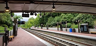
Ronald Reagan Washington National Airport station is a Washington Metro station in Arlington, Virginia on the Blue and Yellow Lines. The station platform is elevated and covered and is the last above-ground station on the Yellow Line in Virginia, heading into Washington, D.C. It is one of only two stations in the system to have three tracks. The station is located across Smith Boulevard from Terminal 2 at Ronald Reagan Washington National Airport; the mezzanine is directly connected to Level 2 of the terminal by two pedestrian bridges. Airport shuttle buses or a walkway connect the station and Terminal 1. The airport's Abingdon Plantation historical site is near the station.

<span class="mw-page-title-main">Pentagon City station</span> Washington Metro station

Pentagon City station is an underground Washington Metro station in the Pentagon City neighborhood of Arlington, Virginia, United States. It serves the Blue and Yellow Lines.

<span class="mw-page-title-main">Arlington Cemetery station</span> Washington Metro station

Arlington Cemetery station is a side platformed Washington Metro station in Arlington, Virginia, United States. The station was opened on July 1, 1977, and is operated by the Washington Metropolitan Area Transit Authority (WMATA). The station provides service for only the Blue Line, and is located at the entrance to Arlington National Cemetery, underneath Memorial Drive. There is no public parking near the station except at the cemetery, which is reserved for cemetery visitors. It is the only station that closes earlier than the rest of the system, closing at 7 PM from October to March, and 10 PM from April to September.

<span class="mw-page-title-main">Capitol South station</span> Washington Metro station

Capitol South station is a Washington Metro station in the Capitol Hill neighborhood of Washington, D.C., United States. The island-platformed station was opened on July 1, 1977, and is operated by the Washington Metropolitan Area Transit Authority (WMATA). The station currently provides service for the Blue, Orange, and Silver Lines.

<span class="mw-page-title-main">Potomac Avenue station</span> Washington Metro station

Potomac Avenue station is an island-platformed Washington Metro station in the Capitol Hill neighborhood of Washington, D.C., United States. The station was opened on July 1, 1977, and is operated by the Washington Metropolitan Area Transit Authority (WMATA). The station currently provides service for the Blue, Orange, and Silver Lines. The station serves a dense residential area of Southeast Washington around Potomac Avenue and is located at 14th and G Streets.

<span class="mw-page-title-main">Metrobus (Washington, D.C.)</span> Bus transit service in the US federal district

Metrobus is a bus service operated by the Washington Metropolitan Area Transit Authority (WMATA). Its fleet consists of 1,595 buses covering an area of 1,500 square miles (3,900 km2) in Washington, D.C., Maryland, and Virginia. There are 269 bus routes serving 11,129 stops, including 2,554 bus shelters. In 2023, the system had a ridership of 103,438,600, or about 366,500 per weekday as of the fourth quarter of 2023.

<span class="mw-page-title-main">Metroway</span> Bus rapid transit line operated by the Washington Metropolitan Area Transit Authority

Metroway is a bus rapid transit (BRT) line operated by the Washington Metropolitan Area Transit Authority (WMATA) as part of their Metrobus system. It consists of a single line operating in Arlington and Alexandria, Virginia. It opened on August 24, 2014. It was the first bus rapid transit line to open in Virginia and in the Washington metropolitan area.

<span class="mw-page-title-main">Columbia Pike–Pentagon City Line</span> Bus routes in the Washington Metropolitan Area

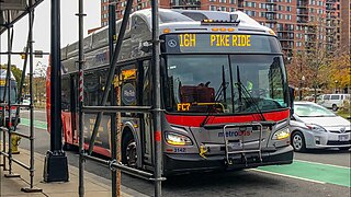
The Columbia Pike–Pentagon City Line, designated as Routes 16G & 16H, were daily bus routes that was operated by the Washington Metropolitan Area Transit Authority between the neighborhoods of Arlington Mill (16G) or Skyline City (16H) and Pentagon City station of the Yellow and Blue lines of the Washington Metro. This line is part of the Pike Ride service, which runs through Columbia Pike. This line provides service through the neighborhoods of Fairfax County and Arlington County to Pentagon City. Unlike the Columbia Pike Line, the Columbia Pike–Pentagon City Line does not serve Columbia Pike past the Arlington County line.

References

  1. "Metrorail Ridership Summary". Washington Metropolitan Area Transit Authority. Retrieved February 8, 2024.
  2. 1 2 3 4 5 "Crystal City Station Access and Second Entrance Study" (PDF). City of Arlington. February 2014. Archived from the original (PDF) on January 28, 2021. Retrieved January 20, 2021.
  3. Feaver, Douglas B. (July 1, 1977). "Today, Metro could be U.S. model". The Washington Post. p. A1.
  4. "Metro's newest stations: Where they are, what's nearby". The Washington Post. June 24, 1977.
  5. "Sequence of Metrorail openings" (PDF). Washington Metropolitan Area Transit Authority. 2017. p. 3. Archived from the original (PDF) on July 2, 2018. Retrieved February 11, 2018.
  6. Fehr, Stephen; Sanchez, Carlos (June 18, 1992). "Getting On Track". Washington Post. ProQuest   408134230. Archived from the original on August 5, 2017. Retrieved August 11, 2020.
  7. "Metroway premium transit service starting this summer" (Press release). WMATA. July 1, 2014. Archived from the original on February 15, 2019. Retrieved June 25, 2016.
  8. Lazo, Luz (February 16, 2019). "Amazon deal delivers 'certainty' for key transportation projects in Northern Virginia". The Washington Post . Archived from the original on February 19, 2019. Retrieved February 19, 2019.
  9. Repetski, Stephen (July 23, 2019). "Metro Reasons: JBG Smith wants to build a new Crystal City station entrance". Greater Greater Washington. Archived from the original on January 28, 2021. Retrieved January 20, 2021.
  10. Repetski, Stephen (June 12, 2020). "Plans for Crystal City Metro's second entrance are moving forward". Greater Greater Washington. Archived from the original on January 28, 2021. Retrieved January 20, 2021.
  11. "Crystal City Metrorail Station East Entrance: Question and Answer Session" (PDF). City of Arlington. March 31, 2021. Archived from the original (PDF) on July 2, 2021. Retrieved July 12, 2021.
  12. DeVoe, Jo (March 18, 2022). "Plans for Crystal City Metro second entrance changed to lower costs". ARLNow. Archived from the original on April 1, 2022. Retrieved March 30, 2022.
  13. DeVoe, Jo (July 14, 2023). "County to ink $117M contract with JBG Smith for second Crystal City Metro entrance". ARLNow. Retrieved July 17, 2023.
  14. "Comprehensive Agreement and Guaranteed Maximum Price (GMP) between East Entrance L.L.C., a Joint Venture between JBG Smith Properties LP and Clark Construction (the Developer) and the Arlington County Board for the Design and Construction of the Crystal City Metrorail Station East Entrance Project". Arlington County Board. July 11, 2023.

Commons-logo.svg Media related to Crystal City station (Washington Metro) at Wikimedia Commons