
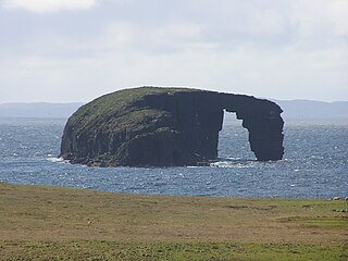
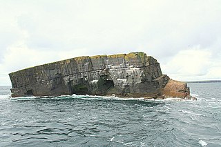
Gloup Holm is an islet in the Shetland Islands, lying to the north of Yell.
Gloup Holm is an islet in the Shetland Islands, lying to the north of Yell.
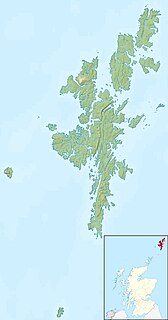
Gloup Holm is near to the part of Yell called North Neaps, near Gloup. [1] It has an area of 30.4 acres [2] or 12.3 hectares.
Rocks to the north include the Clapper and to the south-east is Eagle Stack. To the south west is Bagi Stack and to the west Whilkie Stack.
The island is owned by Robert Henderson, of neighbouring Cullivoe.
Gloup Holm derives its name from the village of Gloup and Gloup Voe on the "mainland" of Yell. These names derive from the Old Norse for a ravine. [1] Gloup Holm belonged to the ancient parish and current quoad sacra parish of North Yell.
Yell is one of the North Isles of Shetland, Scotland. In the 2011 census it had a usually resident population of 966. It is the second largest island in Shetland after the Mainland with an area of 82 square miles (212 km2), and is the third most populous in the archipelago, after the Mainland and Whalsay.
Unst is one of the North Isles of the Shetland Islands, Scotland. It is the northernmost of the inhabited British Isles and is the third-largest island in Shetland after the Mainland and Yell. It has an area of 46 square miles (120 km2).

The North Isles are the northern islands of the Shetland Islands, Scotland. The main islands in the group are Yell, Unst and Fetlar. Sometimes the islands in Yell Sound are included in this group.
Samphrey is an uninhabited island in the Shetland Islands, Scotland. One of Fair Isle's old names is "Friðarey" which is of similar origin.
West Linga is an uninhabited island located between Mainland and Whalsay in Shetland, Scotland.
The Dore Holm is a small uninhabited islet off the south coast of Esha Ness, located in the north-west of Mainland, Shetland, Scotland. Its natural arch can be seen from the coast between Tangwick and Stenness. The shape of the arch has been compared to a horse drinking deeply from the water.
The Horse of Copinsay, also known as the Horse, is a rectangular uninhabited sea stack to the north east of Copinsay in the Orkney Islands, Scotland.

Thieves Holm is a small island in Orkney, Scotland.

Little Roe is an island in Yell Sound in the Shetland Islands

Yell Sound is the strait running between Yell and Mainland, Shetland, Scotland. It is the boundary between the Mainland and the North Isles and it contains many small islands. Sullom Voe, on the shores of which is a substantial oil terminal, is an arm of Yell Sound.

Nesting is a parish in the Shetland Islands, Scotland. It includes a part of the east Shetland Mainland, measuring about twelve by four miles, along the seaboard from Gletness to Lunna Ness, and also the island of Whalsay and the Out Skerries. The coast is deeply indented by voes and headlands. The arable land comprises only about 1,000 acres, the remainder being mostly open moorland. The total area is given as 105.6 km2. This includes the ancient parish of Lunnasting in the North and the island parish of Whalsay to the east, which were added to Nesting in 1891. Before that, the ancient parishes of North Nesting and South Nesting were merged.
Sandsting is a parish in the West Mainland of Shetland, Scotland, forming a southern arm of the Walls Peninsula. After the parish of Aithsting was annexed into Sandsting in the sixteenth century, it became known as Sandsting and Aithsting parish.

Note: Gloup is common in Scottish placenames referring to a sea jet.

For other islands with similar names, see Linga (disambiguation)
There are numerous islands containing the word holm, mainly in northern Europe. In many cases the name is derived from the Old Norse holmr, meaning "a small and rounded islet". These include:
The geography of the North Sea studies coastal and submarine features as well as the people who live on its coasts. It is bounded by the east coasts of England and Scotland to the west and the northern and central European mainland to the east and south, including Norway, Denmark, Germany, the Netherlands, Belgium, and France. In the south-west, beyond the Straits of Dover, the North Sea becomes the English Channel. In the east, it connects to the Baltic Sea via the Skagerrak and Kattegat, narrow straits that separate Denmark from Norway and Sweden respectively. In the north, it opens in a widening funnel shape to the Norwegian Sea, which lies in the very north-eastern part of the Atlantic.

Duirinish is a peninsula on the island of Skye in Scotland. It is situated in the north west between Loch Dunvegan and Loch Bracadale.

St Magnus Bay is a large coastal feature in the north-west of Mainland Shetland, Scotland. Roughly circular in shape with a diameter of about 19 kilometres (12 mi), it is open to the North Atlantic Ocean to the west. The indented coastline to the north, south and east between Esha Ness in the north and the Ness of Melby in the south contains numerous bays, firths and voes and there are several islands around the perimeter. The waters of the bay are up to 165 metres (541 ft) deep and may have been the site of a substantial meteor impact.
| Wikimedia Commons has media related to Gloup Holm . |
| Inhabited islands | ||
|---|---|---|
| Other islands | ||
| Towns and villages | ||
| Points of interest | ||
Coordinates: 60°45′N1°07′W / 60.750°N 1.117°W
| | This Shetland location article is a stub. You can help Wikipedia by expanding it. |