Gold Coast hinterland

Last updated

The Natural Bridge, 2004 Natural Bridge Panorama.jpg
The Natural Bridge, 2004
Cedar Creek Falls in Tamborine National Park, 2011 Cedar Creek Falls in Tamborine National Park.jpg
Cedar Creek Falls in Tamborine National Park, 2011
View towards the coast from Springbrook. The Surfers Paradise skyline can be seen in the distance. View of the Gold Coast, Queensland - Australia, seen from springbrook National Park, April 21 2014. (14642501194).jpg
View towards the coast from Springbrook. The Surfers Paradise skyline can be seen in the distance.

The Gold Coast hinterland is an area of South East Queensland, Australia that comprises the Tweed Range, Nimmel Range, Tamborine Mountain, Numinbah Valley, eastern parts of the McPherson Range and western parts of suburban Gold Coast, such as Mudgeeraba.[ citation needed ] This undefined unit of area is known for its tourist attractions including resorts, rainforest, lookouts, national parks, its diversity of fauna and flora and as a green backdrop to the coastal strip. [1] It overlaps part of the Scenic Rim and is part of both the City of Gold Coast and Scenic Rim Region and includes Springbrook, Binna Burra and O'Reilly.

Contents

History

The comprehensive exploration of the area was conducted only as late as 1842. [2] Surveyors attempting to map the Queensland/New South Wales border during the 1860s were hampered by the rough terrain and plateaus. Shortly after timber-getters passed Numinbah Gap from the Tweed Valley, establishing a route from the Tweed region to Brisbane that was later used by coach and bullock teams. [2] In 1908, Witches Falls was protected by Queensland's first national park declaration. [2]

In September 2019 the area was affected by a severe bushfire season. [3] Binna Burra was destroyed in the fires. [3]

In December 2023, severe storms affected the area. The storms included a tornado which caused widespread destruction. [4]

Tourism

In the Gold Coast hinterland there are various scenic attractions and guesthouses that have led to the development of a vibrant tourism industry, providing a major attraction for visitors to the Gold Coast and people living in the region. Visitor surveys to the hinterland's parks and forests indicate the area is one of Queensland's most significant tourist destinations. [5] Wine-tasting, bird-feeding, eco-tourism and bushwalking are some of the pastimes that attract visitors to the hinterland. [6] Other attractions in the area include O'Reilly's Guesthouse, the Natural Bridge and Binna Burra Lodge. In March 2008, the Gold Coast Hinterland Great Walk connecting the Lamington and Springbrook plateaus was opened. The moderately difficult walking trail provides 54 kilometres (34 mi) of uninterrupted track and takes three days to walk from start to finish. [7]

Geography

Nerang River in Numinbah Valley, 2016 Pocket Road Crossing south on Nerang River, Numinbah Valley, Queensland.jpg
Nerang River in Numinbah Valley, 2016
Numinbah Valley, 1994 Rosin's Lookout Beechmont Queensland.jpg
Numinbah Valley, 1994

This elevated area is part of the Great Dividing Range and contains the headwaters for a number of rivers and creeks including the Coomera River, Nerang River, Pimpama River, Tallebudgera Creek and Currumbin Creek. Some of the highest mountains in the hinterland are Mount Nimmel (489 metres (1,604 ft)), Tamborine Mountain (525 metres (1,722 ft)), Mount Cougal (739 metres (2,425 ft)), Tallebudgera Mountain (664 metres (2,178 ft)) and Springbrook Mountain (900 metres (3,000 ft)).[ citation needed ] In New South Wales to the south are the Tweed Valley and Border Ranges, while the Scenic Rim overlaps[ citation needed ] and extends westwards from the hinterland.

Suburbs and townships

Land use in the hinterland is divided between protected areas and rural residential living. On the eastern foothills of the hinterland lie the Gold Coast suburbs of Mudgeeraba, Tallebudgera, Guanaba, Cedar Creek, Wongawallan, Mt Nathan, Maudsland and Nerang. There are a number of small villages like Advancetown, Beechmont, Lower Beechmont and Canungra that are considered part of the hinterland.

At the foot of Mount Nimmel lies Austinville and beyond, the towering plateau of Springbrook Mountain, on top of which lies a small township by the same name.

Protected areas

Goomoolahra Falls on the Springbrook Plateau Goomoolahra.jpg
Goomoolahra Falls on the Springbrook Plateau

The region has significant natural heritage that is preserved in national parks and has been a major tourist drawcard. [5] Much of the national parks are UNESCO World Heritage-listed as well as listed nationally as part of the Gondwana Rainforests of Australia. Springbrook National Park covers 2,720 hectares (6,700 acres) of rainforest, plenty of which is accessible by walking trails. [8] Remnants of early forestry history remain; there are several waterfalls, including the famous Purlingbrook Falls, and also many gorges and much rainforest.

Lamington National Park covers 20,590 hectares (50,900 acres) of rainforest, consisting mainly of two sections, the Green Mountains and Binna Burra. [9] The longest available walk is 24 kilometres (15 mi), about 8 hours walking time. Tamborine National Park covers 1,160 hectares (2,900 acres) of the Tamborine Mountain, a remnant of the once giant Tweed Volcano.

Closer to the coast, although not technically part of the hinterland, is the Currumbin Valley Reserve.

See also

Related Research Articles

<span class="mw-page-title-main">Lamington National Park</span> Protected area in Queensland, Australia

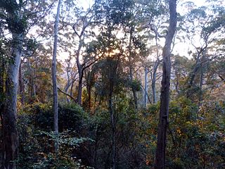
The Lamington National Park is a national park, lying on the Lamington Plateau of the McPherson Range on the Queensland/New South Wales border in Australia. From Southport on the Gold Coast the park is 85 kilometres (53 mi) to the southwest and Brisbane is 110 kilometres (68 mi) north. The 20,600 hectares Lamington National Park is known for its natural environment, rainforests, birdlife, ancient trees, waterfalls, walking tracks and mountain views. The park protects parts of the Eastern Australian temperate forests.

<span class="mw-page-title-main">Springbrook National Park</span> Protected area in Queensland, Australia

The Springbrook National Park is a protected national park that is located in the Gold Coast hinterland of Queensland, Australia. The 6,197-hectare (15,310-acre) park is situated on the McPherson Range, near Springbrook, approximately 100 kilometres (62 mi) south of Brisbane. The park is part of the Shield Volcano Group of the UNESCO World Heritage–listed Gondwana Rainforests of Australia.

<span class="mw-page-title-main">McPherson Range</span> Mountain range in New South Wales, Australia

The McPherson Range is an extensive mountain range, a spur of the Great Dividing Range, heading in an easterly direction from near Wallangarra to the Pacific Ocean coastline. It forms part of the Scenic Rim on the border between the states of New South Wales and Queensland. Further west of the McPherson Range is the Main Range. Towards the coast the range continues into the Border Ranges and other mountainous terrain formed by the Tweed Volcano.

<span class="mw-page-title-main">Tweed Volcano</span> Volcano in New South Wales, Australia

Tweed Volcano is a partially eroded Early Miocene shield volcano located in northeastern New South Wales, which formed when this region of Australia passed over the East Australia hotspot around 23 million years ago. Mount Warning, Lamington Plateau and the Border Ranges between New South Wales and Queensland are among the remnants of this volcano that was originally over 100 kilometres (62 mi) in diameter and nearly twice the height of Mount Warning today, at 1,156 metres (3,793 ft). Despite its size, Tweed Volcano was not a supervolcano; other shield volcanoes—such as in the Hawaiian Islands—are much larger. In the 23 million years since the volcano was active, erosion has been extensive, forming a large erosion caldera around the volcanic plug of Mount Warning. Its erosion caldera is the largest in the Southern Hemisphere.

<span class="mw-page-title-main">Natural Bridge, Queensland</span> Suburb of Gold Coast, Queensland, Australia

Natural Bridge is a rural locality in the City of Gold Coast, Queensland, Australia. It borders New South Wales. In the 2016 census, Natural Bridge had a population of 108 people.

<span class="mw-page-title-main">Binna Burra</span> Building

Binna Burra is a parcel of private land and mountain lodge within the locality of Binna Burra and surrounded by Lamington National Park in Queensland, Australia. It is also a locality in the Scenic Rim Region. The lodge lies in the north-eastern corner of the Lamington Plateau in the McPherson Range, 75 kilometres (47 mi) south of Brisbane in the scenic rim hinterland of the Gold Coast. Binna Burra lies within the catchment of the upper Coomera River.

<span class="mw-page-title-main">South Coast railway line, Queensland</span> Former railway line in Queensland, Australia

The South Coast railway line was a railway from Brisbane, the capital city of Queensland, Australia. The route via the South Coast to Tweed Heads on the border of Queensland and New South Wales. The line operated from 1889 to 1964. The Gold Coast railway line re-opened in 1996 along a modified alignment in the north and a new route south but does not extend as far south yet as the South Coast line.

<span class="mw-page-title-main">Scenic Rim</span> Mountain ranges in Australia

The Scenic Rim is a group of forested mountain ranges of the Great Dividing Range, located south of Brisbane agglomeration, straddling the border between south-eastern Queensland and north-eastern New South Wales, Australia. In 2021, the Scenic Rim was named as a Lonely Planet top destination for 2022.

<span class="mw-page-title-main">Numinbah Valley</span> Town in Queensland, Australia

Numinbah Valley is a rural locality in the City of Gold Coast, Queensland, Australia. In the 2016 census, Numinbah Valley had a population of 218 people.

<span class="mw-page-title-main">Scenic Rim Region</span> Local government area in Queensland, Australia

The Scenic Rim Region is a local government area in West Moreton region of South East Queensland, Australia. Established in 2008, it was preceded by several previous local government areas with histories extending back to the early 1900s and beyond. The main town of the region is Beaudesert.

<span class="mw-page-title-main">Beechmont, Queensland</span> Suburb of Scenic Rim Region, Queensland, Australia

Beechmont is a rural town and locality in the Scenic Rim Region, Queensland, Australia. In the 2016 census, the locality of Beechmont had a population of 842 people.

<span class="mw-page-title-main">Austinville, Queensland</span> Suburb of Gold Coast, Queensland, Australia

Austinville is a hinterland locality in the City of Gold Coast, Queensland, Australia. In the 2016 census, Austinville had a population of 356 people.

<span class="mw-page-title-main">Tallebudgera Creek</span> River in Queensland, Australia

Tallebudgera Creek is a creek in South East Queensland, Australia. Its catchment lies within the Gold Coast local government area and covers an area of 98 square kilometres (38 sq mi). The river is approximately 25 kilometres (16 mi) in length and is known for good fishing.

<span class="mw-page-title-main">Springbrook, Queensland</span> Town in Queensland, Australia

Springbrook is a rural town and locality in the City of Gold Coast, Queensland, Australia. In the 2016 census, the locality of Springbrook had a population of 659 people.

<span class="mw-page-title-main">Currumbin Valley, Queensland</span> Suburb of Gold Coast City, Queensland, Australia

Currumbin Valley is a rural locality in the City of Gold Coast, Queensland, Australia. It borders New South Wales. In the 2021 census, Currumbin Valley had a population of 2,084 people.

Lower Beechmont is a locality in the City of Gold Coast, Queensland, Australia. It is situated in the Gold Coast hinterland. In the 2016 census, Lower Beechmont had a population of 1,046 people.

<span class="mw-page-title-main">Binna Burra, Queensland</span> Suburb of Scenic Rim Region, Queensland, Australia

Binna Burra is a rural locality in the Scenic Rim Region, Queensland, Australia. It borders New South Wales. In the 2021 census, Binna Burra had "no people or a very low population".

<span class="mw-page-title-main">Binna Burra Cultural Landscape</span> Historic site in Queensland, Australia

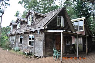
Binna Burra Cultural Landscape includes Binna Burra Lodge, a sustainable, heritage-listed nature-based accommodation and services provider at Binna Burra Road, Binna Burra, Scenic Rim Region, Queensland, Australia. Commencing with a camp in 1933, buildings commenced from 1934 to c. 1980. It was added to the Queensland Heritage Register on 31 December 2002. All of the heritage-listed lodge and adjacent accommodation buildings were destroyed during the September 2019 bushfires.

<span class="mw-page-title-main">Springbrook Road</span> Heritage-listed road in Queensland, Australia

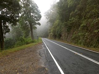
Springbrook Road is a heritage-listed road at Springbrook–Mudgeeraba Road, Springbrook, Gold Coast City, Queensland, Australia. It was built from 1925 to 1928. It is also known as Memorial Cairn, Springbrook–Mudgeeraba Road, and Toll Road. It is part of State Route 99. It was added to the Queensland Heritage Register on 22 October 1999. The road has been closed from Little Nerang Dam since Cyclone Debbie with repairs expected to be completed before 2019.

Nerang–Murwillumbah Road is a continuous 36.4 kilometres (22.6 mi) road route in the Gold Coast region of Queensland, Australia. The entire road is signed as State Route 97. Nerang–Murwillumbah Road is a state-controlled district road, rated as a local road of regional significance (LRRS).

References

  1. Prideaux, Bruce (2014). Prideaux, Bruce (ed.). Rainforest Tourism, Conservation and Management: Challenges for Sustainable Development. Routledge. p. 114. ISBN   978-1136201097 . Retrieved 15 February 2016.
  2. 1 2 3 Queensland Environmental Protection Agency (2000). Heritage Trails of the Great South East. State of Queensland. p. 13. ISBN   0-7345-1008-X.
  3. 1 2 "Queensland bushfires: Binna Burra lodge destroyed as dozens of blazes rage". 7 News. 9 September 2019. Retrieved 29 October 2021.
  4. Colahan, Mackenzie; Andre, Julia; Vujkovic, Melanie (28 December 2023). "More storms and a heatwave are on the way for Queensland after wild weather wreaks havoc over Christmas". ABC News. Retrieved 26 January 2024.
  5. 1 2 "Gold Coast national park tourism contributes $677 million to State Economy". e-Travel Blackboard. Agents Support Systems. 18 November 2008. Retrieved 15 December 2008.
  6. "Gold Coast Hinterland". Australianexplorer.com. 19 November 2006. Retrieved 28 November 2009.
  7. "Gold Coast Hinterland Great Walk". The State of Queensland. 4 March 2009. Archived from the original on 27 April 2009. Retrieved 2 May 2009.
  8. "Springbrook National Park". Gold-coast.net. Retrieved 28 November 2009.
  9. "Lamington National Park". Department of Environment and Resource Management. Archived from the original on 13 August 2012. Retrieved 28 June 2012.