Goldbond, Virginia

Last updated

Goldbond, Virginia
Unincorporated community
Eastern, VA, USA - panoramio (2).jpg
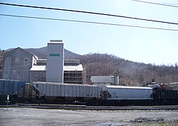
Coal train in Goldbond
Shenandoah Valley.svg
Red pog.svg
Goldbond
USA Virginia location map.svg
Red pog.svg
Goldbond
Usa edcp location map.svg
Red pog.svg
Goldbond
Coordinates: 37°22′48″N80°39′59″W / 37.38000°N 80.66639°W / 37.38000; -80.66639
Country United States
State Virginia
County Giles
Elevation
1,788 ft (545 m)
Time zone UTC-5 (Eastern (EST))
  Summer (DST) UTC-4 (EDT)
ZIP code
24150 [1]
Area code 540
GNIS feature ID1483687 [2]

Goldbond is an unincorporated community in Giles County, Virginia, United States.

Goldbond is located on Stony Creek and State Route 635, 5.3 miles (8.5 km) northeast of Pearisburg. The name Goldbond derives from an earlier limestone processing works situated in the community, National Gypsum Company, which produced 'Gold Bond' gypsum wallboard. Prior to the company's presence, the area was known as Kerns, Virginia, after the Kern's Bread Company which once operated there.

Archaeological evidence collected by locals along with area history suggest the community that is now Goldbond saw military action or at least preparation during the American Civil War; however, no official markers note this at present.

Notable landmarks in the area include two family cemeteries (those of the Moser and Reed Families), a covered mill, a former elementary school (now a private residence), and a former local store which also served as a community U.S. Post Office until its closing on July 30, 2005. Prior to moving to a community post office format Goldbond's post office, which opened February 21, 1923, was operated on land belonging to the Reed Family. This first office was later shifted to the home of Postmasters Irene Moser (née Reed) and Tyree Moser, Sr. in whose family postal operations of the community ran for more than 60 years as noted in an extensive article in the area's newspaper, the 'Virginian Leader,' on the occasion of the couple's retirement and the office's moving in the early 90s.[1]

Related Research Articles

<span class="mw-page-title-main">Post office</span> Customer service facility of a postal system

A post office is a public facility and a retailer that provides mail services, such as accepting letters and parcels, providing post office boxes, and selling postage stamps, packaging, and stationery. Post offices may offer additional services, which vary by country. These include providing and accepting government forms, and processing government services and fees. The chief administrator of a post office is called a postmaster.

<span class="mw-page-title-main">Humble, Texas</span> City in Harris County, Texas, United States

Humble is a city located in the Houston metropolitan area. Humble became an oil boomtown in the early 20th century when oil was first discovered there in 1904. By 1905, the Humble oilfield was the largest producing oilfield in Texas. Humble was home of The Humble Oil and Refining Company, a predecessor of Exxon.

<span class="mw-page-title-main">Tysons, Virginia</span> Census-designated place in Virginia, United States

Tysons, also known as Tysons Corner, is a census-designated place (CDP) in Fairfax County, Virginia, United States, developed from the corner of Chain Bridge Road and the Leesburg Pike. Located in Northern Virginia between the community of McLean and the town of Vienna along the Capital Beltway (I-495), it is in the Washington metropolitan area. Tysons is home to two super-regional shopping malls—Tysons Corner Center and Tysons Galleria—and the corporate and administrative headquarters of numerous companies, such as Intelsat, Alarm.com, Booz Allen Hamilton, Capital One, DXC Technology, Freddie Mac, Gannett, Hilton Worldwide, ID.me and Tegna. As an unincorporated community, Tysons is Fairfax County's central business district and a regional commercial center. It has been called a quintessential example of an edge city. The population was 26,374 as of the 2020 census.

Dulles is an unincorporated area in Loudoun County, Virginia, United States, and is part of the Washington metropolitan area. The headquarters of Northrop Grumman Innovation Systems and ODIN Technologies, as well as the former headquarters of MCI Inc. and AOL are located in Dulles. The National Weather Service Baltimore/Washington forecast office and the National Weather Service's Sterling Field Support Center are also both in Dulles.

<span class="mw-page-title-main">Gorman, California</span> Unincorporated community in California, United States

Gorman is an unincorporated community in northwestern Los Angeles County, California, United States. It is located in Peace Valley south of the Tejon Pass, which links Southern California with the San Joaquin Valley and Northern California. Due to this location, the area has served as a historic travel stop dating back to the indigenous peoples of California. Tens of thousands of motorists travel through Gorman daily on the Golden State Freeway since the highway's completion in the mid-20th Century.

<span class="mw-page-title-main">Sterling, Virginia</span> Census-designated place in Virginia

Sterling, Virginia, refers most specifically to a census-designated place (CDP) in Loudoun County, Virginia, United States. The population of the CDP as of the 2010 United States Census was 27,822. The CDP boundaries are confined to a relatively small area between Virginia State Route 28 on the west and Virginia State Route 7 on the northeast, excluding areas near SR 606 and the Dulles Town Center.

<span class="mw-page-title-main">Mound House, Nevada</span> Unincorporated community in the state of Nevada, United States

Mound House is a small unincorporated community in Lyon County, Nevada on U.S. Route 50 that is situated between Nevada's capital, Carson City, and Dayton. Its elevation is 4,974 feet (1,516 m). It is in Lyon County, one of eight Nevada counties that allow for legalized prostitution, and is home to four brothels.

<span class="mw-page-title-main">Eidson, Tennessee</span> Unincorporated community in Tennessee, United States

Eidson is an unincorporated community located on the north side of Clinch Mountain in Hawkins County, Tennessee. It is part of the Kingsport-Bristol-Bristol, TN-VA Metropolitan Statistical Area, which is a component of the Johnson City-Kingsport-Bristol, TN-VA Combined Statistical Area – commonly known as the "Tri-Cities" region.

Monaville is an unincorporated community and census-designated place (CDP) in Logan County, West Virginia, United States. As of the 2010 census, its population was 309.

Gypsite was a small community at the site of a mill in Kern County, California.

Norton is an unincorporated community in Randolph County, West Virginia, United States. Norton is 6.5 miles (10.5 km) west of Elkins, at the junction of County Route 151 and Corridor H. Norton had a post office, which closed on November 12, 2011. It is a former coal town operated by the West Virginia Coal and Coke Company from the early 1900s until the late 1950s. Besides the mine, the town was once home to a company store, a company bank, and the Norton Grade School. The denominationally unaffiliated Norton Community Church still serves the town.

<span class="mw-page-title-main">Concho, Arizona</span> CDP in Apache County, Arizona

Concho is an unincorporated community and census-designated place (CDP) in Apache County, Arizona, United States. Concho is located on Arizona State Route 61, 14 miles (23 km) west of St. Johns. Concho was the original site for the state capital, due to its prosperous farming. As of the 2010 census, the Concho CDP had a population of 38.

Jodie, also known as Imboden, is an unincorporated community in Fayette County, West Virginia, United States. It is located along the Gauley River at the mouth of Rich Creek, 4 miles (6.4 km) northeast of Gauley Bridge. Due to its proximity to the county line, Jodie is part of the Nicholas County ZIP code of 26690; it had its own post office until its closure on July 23, 2005.

Lambsburg is an unincorporated community in Carroll County, Virginia, United States. Lambsburg is 10.4 miles (16.7 km) east-southeast of Galax. Lambsburg has a post office with ZIP code 24351. The community of Lambsburg Virginia has been around for a couple of hundred years. It was there when Hardin Taliaferro, pronounced "Tolliver" was growing up on Little Fish River in the 1820s: just across the state line in Surry County, North Carolina. Lambsburg was then called "The Hawks Settlement": later called Rocksburg, and still, later, it became Lambsburg.

<span class="mw-page-title-main">Coleman Falls, Virginia</span> Unincorporated community in Virginia, United States

Coleman Falls is an unincorporated community in northern Bedford County, Virginia, United States. The community is located along the James River and U.S. Route 501, between Big Island and Boonsboro. It is part of the Lynchburg Metropolitan Statistical Area.

<span class="mw-page-title-main">Estillfork, Alabama</span> Unincorporated community in Alabama, United States

Estillfork is an unincorporated community in Jackson County, Alabama, United States. It is located in a rugged area at the head of the Paint Rock Valley in northern Jackson County. Just south of the community, the stream with which it shares its name, Estill Fork, joins Hurricane Creek to form the Paint Rock River. The Cumberland Plateau rises immediately to the east, and the Alabama-Tennessee state line passes a few miles to the north.

Abernant is an unincorporated community in Tuscaloosa County, Alabama, United States. Abernant is located along Alabama State Route 216, 3.6 miles (5.8 km) west of Lake View. Abernant has a post office with ZIP code 35440.

Valley was a populated place and post office on the South Branch line of the Baltimore and Ohio Railroad in the U.S. state of West Virginia. It was centered near the intersection of West Sioux Lane and Depot Valley Road, now located within the present-day corporate boundaries of Romney. Valley developed in 1884 following the completion of the South Branch line when the rail line's original southern terminus and corresponding Romney Depot were built there. The United States Post Office Department established a post office at Valley on May 19, 1928, remaining in operation until its disestablishment on June 15, 1937. Following the closure of Valley's post office, its mail was routed through the post office in Romney.

Hybart is an unincorporated community in Monroe County, in the U.S. state of Alabama. Hybart is located at 31°49′36″N87°22′56″W. It is located at the intersection of Alabama State Route 41 and Monroe County Road 56, in the northwestern part of Monroe County, just a short distance from its border with Wilcox County, Alabama. Hybart is the host of a locally famous Alabama turkey hunting competition called the Butterball which has appeared in Mobile Bay Magazine. The area is also known for being a good hunting spot for whitetail deer, turkey, quail, dove, and duck. Hybart is on the northwestern edge of the Red Hills region of southwestern Alabama, a hilly, wooded, and still largely undeveloped part of the state, geologically distinct from the Gulf Coastal Plain to its south, and the Black Belt region to its north. Within the Red Hills region, the Forever Wild Land Trust of Alabama owns two large tracts of land a few miles to the southeast of Hybart. Recreational opportunities in these tracts include hunting, woods road hiking/exploration, wildflower viewing, photography, and bird and wildlife watching. The Red Hills tracts are open to visitors year-round.

Concord is an unincorporated community and former post office in southeastern Hampshire County in the U.S. state of West Virginia. It is located along Eldridge Road between the unincorporated communities of Lehew and Yellow Spring.

References

  1. United States Postal Service (2012). "USPS - Look Up a ZIP Code" . Retrieved February 15, 2012.
  2. "Goldbond". Geographic Names Information System . United States Geological Survey, United States Department of the Interior.