Tibet, or Greater Tibet, is a region in the western part of East Asia, covering much of the Tibetan Plateau and spanning about 2,500,000 km2 (970,000 sq mi). It is the homeland of the Tibetan people. Also resident on the plateau are some other ethnic groups such as the Monpa, Tamang, Qiang, Sherpa and Lhoba peoples and, since the 20th century, considerable numbers of Han Chinese and Hui settlers. Since the annexation of Tibet by the People's Republic of China in 1951, the entire plateau has been under the administration of the People's Republic of China. Tibet is divided administratively into the Tibet Autonomous Region, and parts of the Qinghai, Gansu, Yunnan and Sichuan provinces. Tibet is also constitutionally claimed by the Republic of China as the Tibet Area since 1912. Tibet is the highest region on Earth, with an average elevation of 4,380 m (14,000 ft). Located in the Himalayas, the highest elevation in Tibet is Mount Everest, Earth's highest mountain, rising 8,848.86 m (29,032 ft) above sea level.

The Tibet Autonomous Region, officially the Xizang Autonomous Region, often shortened to Tibet or Xizang, is an autonomous region of China and is part of Southwestern China.

Qinghai is an inland province in Northwestern China. It is the largest province of China by area and has the third smallest population. Its capital and largest city is Xining.

The Tibetan people are an East Asian ethnic group native to Tibet. Their current population is estimated to be around 6.7 million. In addition to the majority living in Tibet Autonomous Region of China, significant numbers of Tibetans live in the Chinese provinces of Gansu, Qinghai, Sichuan, and Yunnan, as well as in India, Nepal, and Bhutan.

The geography of Tibet consists of the high mountains, lakes and rivers lying between Central, East and South Asia. Traditionally, Western sources have regarded Tibet as being in Central Asia, though today's maps show a trend toward considering all of modern China, including Tibet, to be part of East Asia. Tibet is often called "the roof of the world," comprising tablelands averaging over 4,950 metres above the sea with peaks at 6,000 to 7,500 m, including Mount Everest, on the border with Nepal.

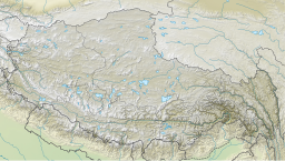
The Tibetan Plateau, also known as Qinghai–Tibet Plateau and Qing–Zang Plateau, is a vast elevated plateau located at the intersection of Central, South, and East Asia covering most of the Tibet Autonomous Region, most of Qinghai, western half of Sichuan, Southern Gansu provinces in Western China, southern Xinjiang, Bhutan, the Indian regions of Ladakh and Lahaul and Spiti as well as Gilgit-Baltistan in Pakistan, northwestern Nepal, eastern Tajikistan and southern Kyrgyzstan. It stretches approximately 1,000 kilometres (620 mi) north to south and 2,500 kilometres (1,600 mi) east to west. It is the world's highest and largest plateau above sea level, with an area of 2,500,000 square kilometres (970,000 sq mi). With an average elevation exceeding 4,500 metres (14,800 ft) and being surrounded by imposing mountain ranges that harbor the world's two highest summits, Mount Everest and K2, the Tibetan Plateau is often referred to as "the Roof of the World".

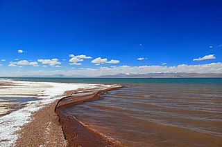
Qinghai Lake, also known by other names, is the largest lake in China. Located in an endorheic basin in Qinghai Province, to which it gave its name, Qinghai Lake is classified as an alkaline salt lake. The lake has fluctuated in size, shrinking over much of the 20th century but increasing since 2004. It had a surface area of 4,317 km2 (1,667 sq mi), an average depth of 21 m (69 ft), and a maximum depth of 25.5 m (84 ft) in 2008.
Hoh Xil or Kekexili, is an isolated region in the northeastern part of Qinghai-Tibet Plateau. On July 7, 2017, the Hoh Xil in Qinghai was listed among the UNESCO World Heritage Sites as "the largest and highest plateau in the world".
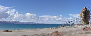
Namtso or Lake Nam is a mountain lake on the border between Damxung County of Lhasa prefecture-level city and Baingoin County of Nagqu Prefecture in the Tibet Autonomous Region of China, approximately 112 kilometres (70 mi) NNW of Lhasa.

Yushu Tibetan Autonomous Prefecture, also transliterated as Yüxü or Yulshul, is an autonomous prefecture of Southwestern Qinghai Province, China. Largely inhabited by Tibetans, the prefecture has an area of 188,794 square kilometres (72,894 sq mi) and its seat is located in the town of Gyêgu in Yushu County, which is the place of the old Tibetan trade mart of Jyekundo. The official source of the Yellow River lies within the prefecture. Historically, the area belongs to the cultural realm of Kham in Eastern Tibet.

Nagqu is a prefecture-level city in the north of the Chinese autonomous region of Tibet. On May 7, 2018, the former Nagqu Prefecture was officially declared the sixth prefecture-level city in Tibet after Lhasa, Shigatse, Chamdo, Nyingchi and Shannan. The regional area, covering an area of 450,537 km2 (173,953 sq mi), is bordered by Bayingolin and Hotan Prefectures of Xinjiang to the north, Haixi, Yushu Prefectures of Qinghai and Chamdo to the east, Nyingchi, Lhasa and Shigatse to the south, Ngari Prefecture to the west. As of the 2010 census, it had a population of 462,381. Since its official establishment in 2018, it is the largest prefecture-level city by area in the world, being slightly larger than Sweden.

The Qaidam, Tsaidam, or Chaidamu Basin is a hyperarid basin that occupies a large part of Haixi Prefecture in Qinghai Province, China. The basin covers an area of approximately 120,000 km2 (46,000 sq mi), one-fourth of which is covered by saline lakes and playas. Around one third of the basin, about 35,000 km2 (14,000 sq mi), is desert.

Xainza County, also Shantsa, Shentsa, is a county within Nagqu of the Tibet Autonomous Region of China. In 1999 the county had a population of 16,190.

The Tanggula, Tangla, Tanglha, or Dangla Mountains is a mountain range in the central part of the Qinghai-Tibet Plateau in Tibet. Administratively, the range is in the Nagqu Prefecture of the Tibet Autonomous Region, with the central section extending into the Tanggula Town and the eastern section entering the Yushu Tibetan Autonomous Prefecture of Qinghai province.

Siling Lake, is a salt lake in the Tibet Autonomous Region, China to the north of Xainza. Doijiang is located near the lake. Administratively it belongs to Xainza County and Baingoin County of the Nagqu.
The following outline is provided as an overview of and topical guide to Tibet:

Urru Lake (Tibetan: འུར་རུ་མཚོ, Wylie: ur ru mtsho; Chinese: 吴如错; pinyin: Wúrú Cuò)is a plateau lake in Nagqu Prefecture, Tibet Autonomous Region, southwest of China, located between Nyima County and Xainza County. The lake, which is part of the Siling Lake drainage system, is fed by several rivers and drains eastward into Jargö Lake. It is 33.6 km long and 13.4 km wide and has an area of 342.7 square km.
The 2021 Maduo earthquake, also known as the 5.22 earthquake struck Madoi County in Qinghai Province, China on 22 May at 02:04 local time. The earthquake had a moment magnitude and surface-wave magnitude of 7.4. Highway bridges, roads and walls collapsed as a result of the earthquake. According to an anonymous source, at least 20 people were killed, 300 were injured, and 13 were missing. Officials stated that there were no deaths but 19 people sustained minor injuries. It was the strongest in China since 2008. It was assigned a maximum intensity of X in Machali, Maduo County on the China seismic intensity scale and Modified Mercalli intensity scale. This earthquake was preceded by another unrelated earthquake that occurred 5 hours earlier in Yunnan.

Bangecuo is a graben basin salt lake on the Tibetan Plateau in Xainza County within Nagqu in the Tibet Autonomous Region of China.
Dazecuo is one of many inland lakes in Tibet. It is a salt lake on the Tibetan Plateau in Xainza County within Nagqu in the Tibet Autonomous Region of China. It was reported in 2021 that the lake receives "good environmental protection".