Goodwill, South Dakota | |
|---|---|
 | |
| Coordinates: 45°33′58″N97°03′21″W / 45.56611°N 97.05583°W | |
| Country | |
| State | |
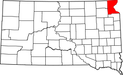
| County | Roberts |
| Elevation | 1,444 ft (440 m) |
| Population (2010) | |
• Total | 513 |
| Time zone | UTC-6 (Central (CST)) |
| • Summer (DST) | UTC-5 (CDT) |
| FIPS code | 46-24775 |
| GNIS feature ID | 2584555 [1] |
Goodwill is an unincorporated community and former census-designated place (CDP) in Roberts County, South Dakota, United States. Prior to the 2020 Census, the CDP was merged into the Agency Village census-designated place. Over 90% of the population is Native American.