Wilmot, South Dakota

Last updated

Wilmot, South Dakota
WilMoNt Korona
Wilmot Sign.JPG
The welcome sign for Wilmot, October 2014
Roberts County South Dakota Incorporated and Unincorporated areas Wilmot Highlighted.svg
Location in Roberts County and the state of South Dakota
Coordinates: 45°24′33″N96°51′16″W / 45.40917°N 96.85444°W / 45.40917; -96.85444
Country United States
State South Dakota
County Roberts
Incorporated1891 [1]
Area
[2]
  Total0.53 sq mi (1.38 km2)
  Land0.53 sq mi (1.38 km2)
  Water0.00 sq mi (0.00 km2)
Elevation
[3]
1,191 ft (363 m)
Population
 (2020) [4]
  Total432
  Density810.51/sq mi (312.94/km2)
Time zone UTC-6 (Central (CST))
  Summer (DST) UTC-5 (CDT)
ZIP code
57279
Area code 605
FIPS code 46-71980
GNIS feature ID1267657 [3]
Website www.wilmotsouthdakota.com

Wilmot is a city in Roberts County, South Dakota, United States. The population was 432 at the 2020 census. [5]

Contents

History

Wilmot, as well as Brookings, were named for Wilmot Brookings, who was provisional governor of the Dakota Territory.

Description

The Wilmot School's mascot is The Wolves. Also known as Gixxlies [6] The local paper is the Wilmot Enterprise. [7]

Wilmot's town and post office were organized in 1881 after a several years period of intense Norwegian homesteading in the area. [8]

Geography

According to the United States Census Bureau, the city has a total area of 0.49 square miles (1.27 km2), all land. [9]

Demographics

Historical population
CensusPop.Note
1900 352
1910 42721.3%
1920 61744.5%
1930 566−8.3%
1940 62811.0%
1950 590−6.1%
1960 467−20.8%
1970 51810.9%
1980 507−2.1%
1990 56611.6%
2000 543−4.1%
2010 492−9.4%
2020 432−12.2%
U.S. Decennial Census [10]
2018 Estimate [11] [4]

2010 census

As of the census [12] of 2010, there were 492 people, 208 households, and 122 families living in the city. The population density was 1,004.1 inhabitants per square mile (387.7/km2). There were 237 housing units at an average density of 483.7 per square mile (186.8/km2). The racial makeup of the city was 89.4% White, 7.9% Native American, 0.4% from other races, and 2.2% from two or more races. Hispanic or Latino of any race were 1.4% of the population.

There were 208 households, of which 28.4% had children under the age of 18 living with them, 45.2% were married couples living together, 8.7% had a female householder with no husband present, 4.8% had a male householder with no wife present, and 41.3% were non-families. 37.5% of all households were made up of individuals, and 18.2% had someone living alone who was 65 years of age or older. The average household size was 2.22 and the average family size was 2.93.

The median age in the city was 45.4 years. 24.8% of residents were under the age of 18; 4.8% were between the ages of 18 and 24; 19.8% were from 25 to 44; 25.4% were from 45 to 64; and 25.2% were 65 years of age or older. The gender makeup of the city was 50.2% male and 49.8% female.

2000 census

As of the census of 2000, there were 543 people, 231 households, and 133 families living in the city. The population density was 1,101.2 inhabitants per square mile (425.2/km2). There were 252 housing units at an average density of 511.0 per square mile (197.3/km2). The racial makeup of the city was 90.98% White, 7.00% Native American, 0.37% Asian, and 1.66% from two or more races. Hispanic or Latino of any race were 0.18% of the population.

There were 231 households, out of which 27.7% had children under the age of 18 living with them, 46.3% were married couples living together, 7.8% had a female householder with no husband present, and 42.4% were non-families. 40.7% of all households were made up of individuals, and 23.4% had someone living alone who was 65 years of age or older. The average household size was 2.24 and the average family size was 3.02.

In the city, the population was spread out, with 25.6% under the age of 18, 5.2% from 18 to 24, 20.4% from 25 to 44, 19.0% from 45 to 64, and 29.8% who were 65 years of age or older. The median age was 44 years. For every 100 females, there were 94.6 males. For every 100 females age 18 and over, there were 84.5 males.

The median income for a household in the city was $25,000, and the median income for a family was $29,750. Males had a median income of $22,125 versus $15,673 for females. The per capita income for the city was $13,561. About 13.6% of families and 16.7% of the population were below the poverty line, including 15.2% of those under age 18 and 22.9% of those age 65 or over.

Transportation

Wilmot is served by two state highways:

Notable people

See also

Related Research Articles

<span class="mw-page-title-main">Tyndall, South Dakota</span> City in South Dakota, United States

Tyndall is a city in and the county seat of Bon Homme County, South Dakota, United States. The population was 1,057 at the 2020 census.

<span class="mw-page-title-main">White, South Dakota</span> City in South Dakota, United States

White is a city in Brookings County, South Dakota, United States. The population was 537 at the 2020 census.

<span class="mw-page-title-main">Wagner, South Dakota</span> City in South Dakota, United States

Wagner is a city in Charles Mix County, South Dakota, United States. The population was 1,490 at the 2020 census. The city is served by Wagner Municipal Airport as well as YST Transit buses.

<span class="mw-page-title-main">Garden City, South Dakota</span> Town in South Dakota, United States

Garden City is a town in Clark County, South Dakota, United States. The population was 33 at the 2020 census.

<span class="mw-page-title-main">Webster, South Dakota</span> City in South Dakota, United States

Webster is a city in and the county seat of Day County, South Dakota, United States. The population was 1,728 at the 2020 census.

<span class="mw-page-title-main">Clear Lake, South Dakota</span> City in South Dakota, United States

Clear Lake is a city in and the county seat of Deuel County, South Dakota, United States. The population was 1,218 at the 2020 census.

<span class="mw-page-title-main">Milbank, South Dakota</span> City in South Dakota, United States

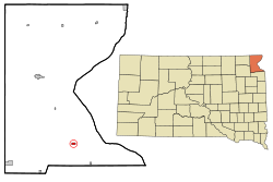
Milbank is a city in Grant County, South Dakota, United States, located along the South Fork of the Whetstone River. The population was 3,544 at the 2020 census. It is the county seat of Grant County. Milbank is the birthplace of American Legion Baseball. The program was created in Milbank in 1925 and is now enjoyed by high school aged youth on more than five thousand teams in all fifty states.

<span class="mw-page-title-main">Gregory, South Dakota</span> City in South Dakota, United States

Gregory is a city in western Gregory County, South Dakota, United States. The population was 1,221 at the 2020 census.

<span class="mw-page-title-main">Miller, South Dakota</span> City in South Dakota, United States

Miller is a city in and county seat of Hand County, South Dakota, United States. The population was 1,349 at the 2020 census.

<span class="mw-page-title-main">Parkston, South Dakota</span> City in South Dakota, United States

Parkston is a city in Hutchinson County, South Dakota, United States. The population was 1,567 at the 2020 census.

<span class="mw-page-title-main">Wentworth, South Dakota</span> Village in South Dakota, United States

Wentworth is an incorporated village in Lake County, South Dakota, United States. It is the only incorporated village in the state of South Dakota. The population was 181 at the 2020 census.

<span class="mw-page-title-main">Central City, South Dakota</span> City in South Dakota, United States

Central City is a city in Lawrence County, South Dakota, United States. The population was 93 at the 2020 census.

<span class="mw-page-title-main">Whitewood, South Dakota</span> City in South Dakota, United States

Whitewood is a city in Lawrence County, South Dakota, United States. The population was 879 at the 2020 census.

<span class="mw-page-title-main">Lennox, South Dakota</span> City in South Dakota, United States

Lennox is a city in Lincoln County, South Dakota, United States, located 20 miles (32 km) southwest of Sioux Falls. The population was 2,423 at the 2020 census.

<span class="mw-page-title-main">Crooks, South Dakota</span> City in South Dakota, United States

Crooks is a city in Minnehaha County, South Dakota, United States and is a suburb of Sioux Falls. The population was 1,362 at the 2020 census. Crooks was named New Hope until 1904. The town's present name honors W. A. Crooks, a local politician.

<span class="mw-page-title-main">Garretson, South Dakota</span> City in South Dakota, United States

Garretson is a city in Minnehaha County, South Dakota, United States. The city had a population of 1,228 at the 2020 census.

<span class="mw-page-title-main">Hartford, South Dakota</span> City in South Dakota, United States

Hartford is a suburban American city in Minnehaha County, South Dakota, a few miles northwest of Sioux Falls. Its population was 3,354 at the 2020 census.

<span class="mw-page-title-main">Mission, South Dakota</span> City in South Dakota, United States

Mission is a city on the Rosebud Indian Reservation in northern Todd County, South Dakota, United States. The population was 1,156 at the 2020 census.

<span class="mw-page-title-main">Elk Point, South Dakota</span> City in South Dakota, United States

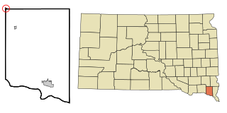
Elk Point is a city in and county seat of Union County, South Dakota, United States. The population was 2,149 as of the 2020 census.

<span class="mw-page-title-main">Irene, South Dakota</span> City in South Dakota, United States

Irene is a city in Clay, Turner, and Yankton counties in South Dakota, United States. The population was 422 at the 2020 census. The portion of Irene that is located in Turner County is a part of the Sioux Falls, South Dakota metropolitan area, the portion located in Yankton County is part of the Yankton Micropolitan Statistical Area, and the portion located in Clay County is part of both the Vermillion Micropolitan Statistical Area and the Sioux City-Vermillion Combined Statistical Area. Irene is also host to the Irene Rodeo, held every summer.

References

  1. "SD Towns" (PDF). South Dakota State Historical Society . Retrieved February 17, 2010.
  2. "ArcGIS REST Services Directory". United States Census Bureau. Retrieved October 15, 2022.
  3. 1 2 U.S. Geological Survey Geographic Names Information System: Wilmot, South Dakota
  4. 1 2 "Census Population API". United States Census Bureau. Retrieved October 15, 2022.
  5. "U.S. Census Bureau: Wilmot city, South Dakota". www.census.gov. United States Census Bureau. Retrieved January 28, 2022.
  6. "Wilmot School Home Page". Wilmot School District . Retrieved October 12, 2014.
  7. "SmallTownPapers - The Wilmot Enterprise, Wilmot South Dakota". SmallTownPapers . Retrieved October 12, 2014.
  8. Federal Writers' Project (1940). South Dakota place-names, v.1-3. University of South Dakota. p. 69.
  9. "US Gazetteer files 2010". United States Census Bureau . Retrieved June 21, 2012.
  10. United States Census Bureau. "Census of Population and Housing" . Retrieved July 20, 2014.
  11. "Population Estimates". United States Census Bureau . Retrieved June 8, 2018.
  12. "U.S. Census website". United States Census Bureau . Retrieved June 21, 2012.