
Westchester County is a county located in the southeastern portion of the U.S. state of New York, bordering the Long Island Sound to its east and the Hudson River on its west. The county is the seventh most populous county in the State of New York and the most populous north of New York City. According to the 2020 United States Census, the county had a population of 1,004,456, its highest decennial count ever and an increase of 55,344 (5.8%) from the 949,113 counted in 2010. Westchester covers an area of 450 square miles (1,200 km2), consisting of six cities, 19 towns, and 23 villages. Established in 1683, Westchester was named after the city of Chester, England. The county seat is the city of White Plains, while the most populous municipality in the county is the city of Yonkers, with 211,569 residents per the 2020 census. The county is part of the Hudson Valley region of the state.

La Rochelle is a city on the west coast of France and a seaport on the Bay of Biscay, a part of the Atlantic Ocean. It is the capital of the Charente-Maritime department. With 78,535 inhabitants in 2021, La Rochelle is the most populated commune in the department and ranks fourth in the Nouvelle-Aquitaine region after Bordeaux, the regional capital, Limoges and Poitiers.

New Rochelle is a city in Westchester County, New York, United States. It is a suburb of New York City, located approximately 17 miles (27 km) from Midtown Manhattan. In 2020, the city had a population of 79,726, making it the 7th-largest city and 22nd-most populous municipality in New York.

The Pelham Islands are a group of islands in western Long Island Sound that belonged to Thomas Pell in the 17th century. The islands, and most of the surrounding area, were purchased from the Siwanoy Indians by Pell in 1654, creating Pelham Manor. This large tract of land would eventually become the present-day Town and Village of Pelham and Pelham Manor, Town of Eastchester, cities of New Rochelle and Mount Vernon in Westchester County, and the Pelham Bay and Eastchester neighborhoods of the Bronx in New York City.
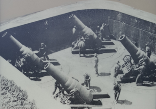
Fort Slocum, New York was a US military post which occupied Davids Island in the western end of Long Island Sound in the city of New Rochelle, New York, from 1867 to 1965. The fort was named for Major General Henry W. Slocum, a Union corps commander in the American Civil War.

The Hutchinson River is a 10 mile-long (16 km) freshwater stream located in the New York City borough of the Bronx and Southern Westchester County, New York, United States. It forms on the New Rochelle–Scarsdale municipal line off Brookline Road in the latter community and flows south, draining a 19.4-square-mile (50 km2) area. It continues to serve as New Rochelle's city line with Eastchester; further downstream; its lower reaches divide Mount Vernon and Pelham until it enters the Bronx and empties into Long Island Sound's Eastchester Bay.
Goose Island may refer to:

Davids Island is a 78-acre (32 ha) island off the coast of New Rochelle, New York, in Long Island Sound. Currently uninhabited, it was previously the site of Fort Slocum. The island is home to the endangered Kemp's ridley sea turtle, and birds such as osprey and least terns. Davids Island also supports valuable wetlands, rare rocky intertidal areas, and sandy beaches. The waters surrounding the island are home to winter flounder, Atlantic herring, and Atlantic silverside.

Columbia Island, is an island in the Long Island Sound and part of New Rochelle, New York, United States. It is situated off the south-eastern coast of Davids Island, immediately adjacent to Pea Island. Before sea walls and other structures were built on the island, the exposed rock varied in size from about one acre to 175 square feet depending on the tide.
Neptune Island is an island in Long Island Sound and part of the City of New Rochelle, New York. It is connected to the mainland by a stone causeway topped by Neptune Road. A dam at the peninsula's east end creates a small pond, and its west shore edges the Neptune Basin inlet.
Pea Island is a small island in Long Island Sound and a part of the city of New Rochelle in Westchester County, New York. It features a rocky, grass-covered terrain, with exposed rocks at low tide. The island lies approximately 1 mile (1.6 km) from the New Rochelle shore, adjacent to Davids and Columbia islands. It is the southernmost location in New Rochelle.
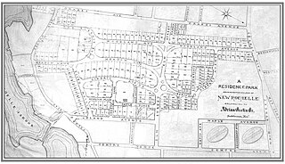
Residence Park is a historic community located in the city of New Rochelle, in Westchester County, New York. It is one of the first planned residential parks, and garden city communities, in the United States. It is located in the southern section of the city, bordered by Neptune Park on the west, Shore Road and Long Island Sound on the south, and Downtown New Rochelle on the north.
Sutton Manor is a distinctive early 20th century suburban residential district in the city of New Rochelle in Westchester County, New York. The neighborhood is located off the northern shore of Long Island Sound on Echo Bay. It was developed as an upper middle class enclave for families with heads of households employed in New York City and served as a model for the ideal suburban setting; harmonious architecture and exclusive amenities. The development appears to have been modeled on neighboring Larchmont Manor in the Town of Mamaroneck, yet on a smaller scale. That subdivision was conceived originally as an exclusive and convenient seasonal playground for New York’s wealthy upper classes, with its 6-acre waterfront park.
Titus Mill Pond & New York State Tidal Wetlands is located at the northeastern end of New Rochelle Harbor in the city of New Rochelle in Westchester, New York. The waters in the harbor and pond flow from Long Island Sound, with tides up to eight feet in the inlet and with no fresh water stream entering into it.
New Rochelle Harbor is the name of a harbor located along Long Island Sound in the city of New Rochelle in Westchester County, New York. The Davenport Neck peninsula off the mainland divides New Rochelle's waterfront into two bays; the westerly referred to as New Rochelle Harbor and the easterly as Echo Bay.
Echo Bay is an embayment located off Long Island Sound in the city of New Rochelle in Westchester County, New York. It is an anchorage for small craft and is generally fully occupied during the summer. The depths at the anchorage range from 4 to 15 feet, and launches can anchor in the shallow cove on the northeast side of the harbor, entering between Harrison Islands and the rocky, grassy islet off the northwest side of Echo Island. Vessels frequently anchor between the entrance of Echo Bay and Hicks Ledge, in depths of 20 to 24 feet. On the northwest side of Echo Bay a dredged channel 100 feet wide and 15 feet deep, marked by buoys, leads to the New Rochelle Municipal Marina at Beaufort Point.
Premium Point is a guard-gated private community in the city of New Rochelle in Westchester County, New York, United States. The area consists of a series small islands connected by bridges to a peninsular fronting on Long Island Sound and backing on Premium Mill Pond and Echo Bay. Much of the shore line of Premium Point is high and rocky, both on the Sound and on the Bay. Premium Mill Pond is located between the Premium Point peninsula and the mainland. It is fed by the Premium River and is separated from Echo Bay by the former Premium Mill dam.
Middle Ground is a large submerged reef in Long Island Sound and part of the city of New Rochelle, Westchester County, New York. This underwater embankment formed from the natural accumulation of rock and sand in shallow coastal waters. Rock outcrops just below the surface at the center of Middle Ground become exposed during low tide. Stripers and Bluefish are attracted to the shoal throughout the warmer season.
Pine Island is a small, privately owned island in the city of New Rochelle in Westchester County, New York. The island is situated off the coast of Davenport Neck near Sans Souci Beach in Long Island Sound.

