
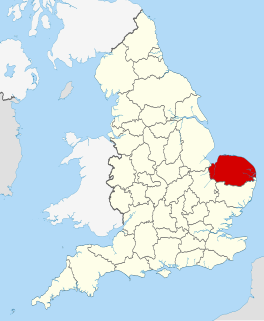
Norfolk is a county in East Anglia in England. It borders Lincolnshire to the northwest, Cambridgeshire to the west and southwest, and Suffolk to the south. Its northern and eastern boundaries are the North Sea and to the northwest, The Wash. The county town is Norwich. With an area of 2,074 square miles (5,370 km2) and a population of 859,400, Norfolk is a largely rural county with a population density of 401 per square mile. Of the county's population, 40% live in four major built up areas: Norwich (213,000), Great Yarmouth (63,000), King's Lynn (46,000) and Thetford (25,000).

Reedham is a village and civil parish in the English county of Norfolk and within The Broads. It is on the north bank of the River Yare, some 12 miles (19 km) east of the city of Norwich, 7.5 mi (12.1 km) south-west of the town of Great Yarmouth and the same distance north-west of the Suffolk town of Lowestoft.

Swaffham is a market town and civil parish in the Breckland District and English county of Norfolk. It is situated 12 miles east of King's Lynn and 31 miles west of Norwich.

The A47 is a trunk road in England linking Birmingham to Lowestoft, Suffolk. Most of the section between Birmingham and Nuneaton is now classified as the B4114.

Mid Norfolk is a constituency represented in the House of Commons of the UK Parliament since 2010 by George Freeman, a Conservative.

Attlebridge is a village and civil parish in the English county of Norfolk. It is situated about 8 miles (13 km) north-west of Norwich, where the A1067 crosses the River Wensum.

Bawdeswell is a small rural village and civil parish in Norfolk, England. At the time of the 2011 census it had a population of 828 and an area of 487 hectares. The village is situated almost in the centre of Norfolk about 14 miles (23 km) northwest of Norwich. For the purposes of local government is falls within the Upper Wensum Ward of Breckland District Council and the Elmham and Mattishall Division of Norfolk County Council. It is on a Roman road that ran east–west between Durobrivae near modern Peterborough and Smallburgh, crossing the Fen Causeway.

Billingford is a village and civil parish in the Breckland district of Norfolk, England, about 3 1⁄2 miles (5.6 km) north of East Dereham. The village is just north of the River Wensum, which forms the southern boundary of the parish. The village is on the B1145 road, which links King's Lynn and Mundesley. The 2011 Census recorded the parish population as 253.

Litcham is a village and civil parish in the English county of Norfolk. It is situated some 10 km (6.2 mi) north-east of the town of Swaffham and 40 km (25 mi) west of the city of Norwich. The village is located on the B1145 a route which runs between King's Lynn and Mundesley.
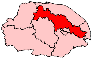
Broadland is a Norfolk constituency, which has been represented in parliament since the 2019 general election by Jerome Mayhew, a Conservative.
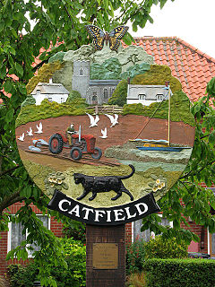
Catfield is a village and a civil parish in the English county of Norfolk. The village is 19.7 miles (31.7 km) south-east of Cromer, 17.3 miles (27.8 km) north-east of Norwich and 136 miles (219 km) north-east of London. The village lies 2.7 miles (4.3 km) south-south-east of the nearby town of Stalham. The nearest railway station is at Worstead for the Bittern Line which runs between Sheringham, Cromer and Norwich. The nearest airport is Norwich International Airport. The village is situated a little west of the A149 King’s Lynn to Great Yarmouth road. The parish had in 2001 census, a population of 848, increasing to 943 at the 2011 Census. For the purposes of local government, the parish falls within the district of North Norfolk.
Norfolk County Council is the top tier local government authority for Norfolk, England. Its headquarters are based in the city of Norwich.
The county of Norfolk is divided into seven districts. The districts of Norfolk Norwich, South Norfolk, Great Yarmouth, Broadland, North Norfolk, King's Lynn and West Norfolk, and Breckland.
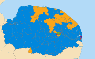
The Norfolk County Council election took place on 4 June 2009, coinciding with local elections for all county councils in England.
There are over 20,000 Grade II* listed buildings in England. This page is a list of 102 of these buildings in the district of Breckland in Norfolk.
There are over 20,000 Grade II* listed buildings in England. This page is a list of these buildings in the district of Broadland in Norfolk.
There are over 9,000 Grade I listed buildings in England. This page is a list of these buildings in the district of Breckland in Norfolk.
There are over 9,000 Grade I listed buildings in England. This page is a list of these buildings in the district of Broadland in Norfolk.
This page is based on this
Wikipedia article Text is available under the
CC BY-SA 4.0 license; additional terms may apply.
Images, videos and audio are available under their respective licenses.
