
Surrey is a county in South East England which borders Kent to the east, East Sussex to the southeast, West Sussex to the south, Hampshire to the west, Berkshire to the northwest, and Greater London to the northeast. With about 1.2 million people, Surrey is the 12th-most populous English county, the third-most populous home county, after Kent and Essex, and the third-most populous in the Southeast, after Hampshire and Kent.

Reigate and Banstead is a local government district with borough status in east Surrey, England. It includes the towns of Reigate, Redhill, Horley and Banstead. The borough borders the Borough of Crawley to the south, the Borough of Epsom and Ewell and District of Mole Valley to the west, Tandridge District to the east and the London Boroughs of Sutton and Croydon to the north.

Elmbridge is a local government district with borough status in Surrey, England. Its principal towns and villages are Esher, Cobham, Walton-on-Thames, Weybridge and Molesey. It directly borders the London Borough of Richmond upon Thames and the London Royal Borough of Kingston upon Thames. Some areas of the borough form a continuation of the Greater London Built-up Area, formerly falling into the Metropolitan Police District.
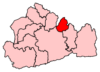
Epsom and Ewell is a constituency represented in the House of Commons of the UK Parliament since 2001 by Chris Grayling, a Conservative.
The KT postcode area, also known as the Kingston upon Thames postcode area, is a group of 24 postcode districts in England, within 19 post towns. These cover boroughs in south-west Greater London and several boroughs in north-east Surrey.

Nork is a residential area of the borough of Reigate and Banstead in Surrey and borders Greater London, England. Nork is separated from its post town Banstead only by the A217 dual carriageway, and the built-up area is also contiguous with similar parts of Tattenham Corner and Burgh Heath. A thin belt of more open land separates it from the communities to the north: Epsom, Ewell, Cheam and Belmont. There are two parades of shops, one called the Driftbridge and another at the north-eastern end of Nork Way, the street which runs centrally through the residential area. Nork lies on chalk near the top of the gentle north-facing slope of the North Downs, 175 m (575 ft) above sea level at its highest point.
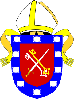
The Diocese of Guildford is a Church of England diocese covering eight and half of the eleven districts in Surrey, much of north-east Hampshire and a parish in Greater London. The cathedral is Guildford Cathedral and the bishop is the Bishop of Guildford. Of the two provinces of the church, it is in the Province of Canterbury.

Surrey County Council is the county council administering certain services in the non-metropolitan county of Surrey in England. The council is composed of 81 elected councillors, and in all but one election since 1965 the Conservative Party has held the majority. The leader of the council is Tim Oliver.

Kingswood or Kingswood with Burgh Heath is a residential area on the North Downs in the Borough of Reigate and Banstead in Surrey, England. Part of the London commuter belt, Kingswood is just to the east of the A217 separating it from Tadworth and has a railway station. Burgh Heath in its north is combined with it to form a ward. Reigate is 3.6 miles (5.8 km) south of its centre and London is 15.5 miles (24.9 km) to the north northeast. Kingswood with Burgh Heath had a population of 6,891 in 2011.
The RH postcode area, also known as the Redhill postcode area, is a group of twenty postcode districts in South East England, within seventeen post towns. These cover east Surrey and northeastern West Sussex plus small parts of northwestern East Sussex.

West Surrey was a parliamentary constituency in the county of Surrey, which returned two Members of Parliament (MPs) to the House of Commons of the Parliament of the United Kingdom, elected by the bloc vote system.
Local transport bodies are partnerships of local authorities in England outside Greater London. There are 38 local transport bodies. They cover similar areas to local enterprise partnerships, but are not permitted to overlap each other. Decision making for major transport infrastructure spending is devolved to these bodies from the Department for Transport. They will receive funding from April 2015.
This page is based on this
Wikipedia article Text is available under the
CC BY-SA 4.0 license; additional terms may apply.
Images, videos and audio are available under their respective licenses.
