
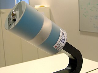
A gradiometer measures the gradient (numerical rate of change) of a physical quantity, such as a magnetic field or gravity. [1]
A gradiometer measures the gradient (numerical rate of change) of a physical quantity, such as a magnetic field or gravity. [1]
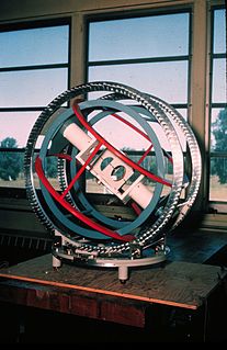
There are at least two types of gradiometer to measure magnetic fields:
Each sensor type responds differently to certain spatial signals.
Axial gradiometers are good for measuring depth, while planar gradiometers can measure weak signals even under a lot of noise. [2]

An electromagnetic coil is an electrical conductor such as a wire in the shape of a coil, spiral or helix. Electromagnetic coils are used in electrical engineering, in applications where electric currents interact with magnetic fields, in devices such as electric motors, generators, inductors, electromagnets, transformers, and sensor coils. Either an electric current is passed through the wire of the coil to generate a magnetic field, or conversely an external time-varying magnetic field through the interior of the coil generates an EMF (voltage) in the conductor.

A SQUID is a very sensitive magnetometer used to measure extremely subtle magnetic fields, based on superconducting loops containing Josephson junctions.

A magnetometer is a device that measures magnetism—the direction, strength, or relative change of a magnetic field at a particular location. The measurement of the magnetization of a magnetic material is an example. A compass is one such device, one that measures the direction of an ambient magnetic field, in this case, the Earth's magnetic field.

Time of flight (ToF) is the measurement of the time taken by an object, particle or wave to travel a distance through a medium. This information can then be used to establish a time standard, as a way to measure velocity or path length, or as a way to learn about the particle or medium's properties. The traveling object may be detected directly or indirectly.
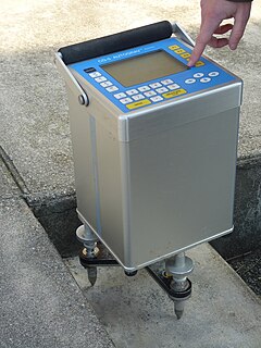
A proton magnetometer, also known as a proton precession magnetometer (PPM), uses the principle of Earth's field nuclear magnetic resonance (EFNMR) to measure very small variations in the Earth's magnetic field, allowing ferrous objects on land and at sea to be detected.
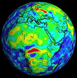
A gravimeter is an instrument used to measure gravitational acceleration. Every mass has an associated gravitational potential. The gradient of this potential is a force. A gravimeter measures this gravitational force.
Diffusion-weighted magnetic resonance imaging is the use of specific MRI sequences as well as software that generates images from the resulting data that uses the diffusion of water molecules to generate contrast in MR images. It allows the mapping of the diffusion process of molecules, mainly water, in biological tissues, in vivo and non-invasively. Molecular diffusion in tissues is not free, but reflects interactions with many obstacles, such as macromolecules, fibers, and membranes. Water molecule diffusion patterns can therefore reveal microscopic details about tissue architecture, either normal or in a diseased state. A special kind of DWI, diffusion tensor imaging (DTI), has been used extensively to map white matter tractography in the brain.
Magnetic flux leakage is a magnetic method of nondestructive testing that is used to detect corrosion and pitting in steel structures, most commonly pipelines and storage tanks. The basic principle is that a powerful magnet is used to magnetize the steel. At areas where there is corrosion or missing metal, the magnetic field "leaks" from the steel. In an MFL tool, a magnetic detector is placed between the poles of the magnet to detect the leakage field. Analysts interpret the chart recording of the leakage field to identify damaged areas and to estimate the depth of metal loss.
Geophysical survey is the systematic collection of geophysical data for spatial studies. Detection and analysis of the geophysical signals forms the core of Geophysical signal processing. The magnetic and gravitational fields emanating from the Earth's interior hold essential information concerning seismic activities and the internal structure. Hence, detection and analysis of the electric and Magnetic fields is very crucial. As the Electromagnetic and gravitational waves are multi-dimensional signals, all the 1-D transformation techniques can be extended for the analysis of these signals as well. Hence this article also discusses multi-dimensional signal processing techniques.
Gravity gradiometry is the study and measurement of variations in the acceleration due to gravity. The gravity gradient is the spatial rate of change of gravitational acceleration.
In geophysics, a magnetic anomaly is a local variation in the Earth's magnetic field resulting from variations in the chemistry or magnetism of the rocks. Mapping of variation over an area is valuable in detecting structures obscured by overlying material. The magnetic variation in successive bands of ocean floor parallel with mid-ocean ridges is important evidence supporting the theory of seafloor spreading, central to plate tectonics.

The Magnetospheric Multiscale (MMS) Mission is a NASA robotic space mission to study the Earth's magnetosphere, using four identical spacecraft flying in a tetrahedral formation. The spacecraft were launched on 13 March 2015 at 02:44 UTC. The mission is designed to gather information about the microphysics of magnetic reconnection, energetic particle acceleration, and turbulence—processes that occur in many astrophysical plasmas. As of March 2020, the MMS spacecraft have enough fuel to remain operational until 2040.
Spacecraft magnetometers are magnetometers used aboard spacecraft and satellites, mostly for scientific investigations, plus attitude sensing. Magnetometers are among the most widely used scientific instruments in exploratory and observation satellites. These instruments were instrumental in mapping the Van Allen radiation belts around Earth after its discovery by Explorer 1, and have detailed the magnetic fields of the Earth, Moon, Sun, Mars, Venus and other planets and moons. There are ongoing missions using magnetometers, including attempts to define the shape and activity of Saturn's core.

Magnetic surveying is one of a number of methods used in archaeological geophysics. Magnetic surveys record spatial variation in the Earth's magnetic field. In archaeology, magnetic surveys are used to detect and map archaeological artefacts and features. Magnetic surveys are used in both terrestrial and marine archaeology.
EMF measurements are measurements of ambient (surrounding) electromagnetic fields that are performed using particular sensors or probes, such as EMF meters. These probes can be generally considered as antennas although with different characteristics. In fact, probes should not perturb the electromagnetic field and must prevent coupling and reflection as much as possible in order to obtain precise results. There are two main types of EMF measurements:
The Lviv Centre of the Space Research Institute of the NASU and NSAU is a Lviv branch of the actual institute.

The physics of magnetic resonance imaging (MRI) concerns fundamental physical considerations of MRI techniques and technological aspects of MRI devices. MRI is a medical imaging technique mostly used in radiology and nuclear medicine in order to investigate the anatomy and physiology of the body, and to detect pathologies including tumors, inflammation, neurological conditions such as stroke, disorders of muscles and joints, and abnormalities in the heart and blood vessels among others. Contrast agents may be injected intravenously or into a joint to enhance the image and facilitate diagnosis. Unlike CT and X-ray, MRI uses no ionizing radiation and is, therefore, a safe procedure suitable for diagnosis in children and repeated runs. Patients with specific non-ferromagnetic metal implants, cochlear implants, and cardiac pacemakers nowadays may also have an MRI in spite of effects of the strong magnetic fields. This does not apply on older devices, details for medical professionals are provided by the device's manufacturer.
Attitude control is the process of controlling the orientation of an aerospace vehicle with respect to an inertial frame of reference or another entity such as the celestial sphere, certain fields, and nearby objects, etc.
Geophysical signal analysis is concerned with the detection and a subsequent processing of signals. Any signal which is varying conveys valuable information. Hence to understand the information embedded in such signals, we need to 'detect' and 'extract data' from such quantities. Geophysical signals are of extreme importance to us as they are information bearing signals which carry data related to petroleum deposits beneath the surface and seismic data. Analysis of geophysical signals also offers us a qualitative insight into the possibility of occurrence of a natural calamity such as earthquakes or volcanic eruptions.

Magnetometer (MAG) is the name of an instrument suite on the Juno orbiter for planet Jupiter. The MAG instrument includes both the Fluxgate Magnetometer (FGM) and Advanced Stellar Compass (ASC) instruments. There two sets of MAG instrument suites, and they are both positioned on the far end of three solar panel array booms. Each MAG instrument suite observes the same swath of Jupiter, and by having two sets of instruments, determining what signal is from the planet and what is from spacecraft is supported. Avoiding signals from the spacecraft is another reason MAG is placed at the end of the solar panel boom, about 10 m and 12 m away from the central body of the Juno spacecraft.
| This standards- or measurement-related article is a stub. You can help Wikipedia by expanding it. |