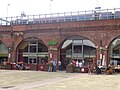
Granary Wharf

Last updated

Granary Wharf
Granary Wharf, Leeds - geograph.org.uk - 4976158.jpg
Granary Wharf
General information
StatusCompleted
Location Leeds, England
Completed2009
Opening2009
Height
RoofCandle House: 76 m (249 ft)
Watermans Place: 50 m (160 ft)
DoubleTree: 48 m (157 ft)
Technical details
Floor countCandle House: 23
Watermans Place: 17
DoubleTree: 15

Granary Wharf is a mixed-use development that stands next to the brick tunnels beside the Leeds and Liverpool Canal, and the River Aire in Leeds, West Yorkshire, England. Leeds City railway station sits above the brick tunnels on Dark Neville Street. The tunnel complex is known locally as the Dark Arches. [1]

Contents

History

In 1864 it was proposed to build a "New Station" in Leeds. Construction began in 1866 and the station was completed in 1869. The new station was built on arches which span the River Aire, Neville Street and Swinegate. The building of the station led to the creation of the 'Dark Arches' over Neville Street. Over 18 million bricks were used during their construction, breaking records at the time[ citation needed ].

Although the arches appear to be part of one single structure, closer inspection reveals that it is a series of independent viaducts two or four tracks wide[ citation needed ]. The station is situated next to the terminus of the Leeds and Liverpool Canal, but as the station is raised high above ground level it is possible to gain access to the Dark Arches from the towpath.

Developed in the 1990s and advertised as Leeds' best kept secret, the Granary Wharf shopping centre was situated underneath the Dark Arches. There were several established businesses underneath the arches, these included; restaurants, shops, boutiques, cafes, a bakery, exhibition spaces and a 1,000 capacity events venue. The Arches as a shopping centre was in decline for some time, and has now been developed as a car park. [ citation needed ]

In 2009 Granary Wharf was redeveloped with a new hotel (the City Inn, Leeds - now DoubleTree by Hilton) and two apartment blocks: Candle House and Watermans Place. [2] The newly developed Granary Wharf also features several modern restaurants and bars. [3]

Related Research Articles

<span class="mw-page-title-main">Leeds and Liverpool Canal</span> Canal in the north of England

The Leeds and Liverpool Canal is a canal in Northern England, linking the cities of Leeds and Liverpool.

<span class="mw-page-title-main">Saltaire</span> Village in West Yorkshire, England

Saltaire is a Victorian model village in Shipley, West Yorkshire, England, situated between the River Aire, the railway, and the Leeds and Liverpool Canal. Salt's Mill and the houses were built by Titus Salt between 1851 and 1871 to allow his workers to live in better conditions than the slums of Bradford. The mill ceased production in 1986, and was converted into a multifunctional location with an art gallery, restaurants, and the headquarters of a technology company. It is a UNESCO World Heritage Site and on the European Route of Industrial Heritage.

<span class="mw-page-title-main">Airedale</span> Valley in North and West Yorkshire, England

Airedale is a valley, or dale, in North Yorkshire and West Yorkshire, England. It is named after the River Aire, which flows through it. The upper valley, from Malham Cove to Airton, is known as Malhamdale, named after the village of Malham. At Airton the valley widens and becomes Airedale proper. The river flows past Skipton on to Keighley, Bingley, Shipley, and Leeds.

<span class="mw-page-title-main">Castlefield</span> Human settlement in England

Castlefield is an inner-city conservation area in Manchester, North West England. The conservation area which bears its name is bounded by the River Irwell, Quay Street, Deansgate and Chester Road. It was the site of the Roman era fort of Mamucium or Mancunium which gave its name to Manchester. It was the terminus of the Bridgewater Canal, the world's first industrial canal, built in 1764; the oldest canal warehouse opened in 1779. The world's first passenger railway terminated here in 1830, at Liverpool Road railway station and the first railway warehouse opened here in 1831.

<span class="mw-page-title-main">Leeds railway station</span> Mainline railway station in Leeds, West Yorkshire, England

Leeds railway station is the mainline railway station serving the city centre of Leeds in West Yorkshire, England. It is located on New Station Street to the south of City Square, at the foot of Park Row, behind the landmark Queens Hotel. It is one of 20 stations managed by Network Rail. As of December 2023, it was the busiest station in West Yorkshire, as well as in Yorkshire & the Humber, and the entirety of Northern England. It is the second busiest station in the UK outside of London, after Birmingham New Street.

<span class="mw-page-title-main">Burscough</span> Town in West Lancashire, England

Burscough is a town and civil parish in the district of West Lancashire, Lancashire, England. The town is located approximately 13.5 miles (21.7 km) north-northeast of Liverpool and 13 miles (21 km) southwest of Preston. Its northern part is called Burscough Bridge, and was originally a separate settlement.

<span class="mw-page-title-main">Leeds city centre</span> Central business district of Leeds, West Yorkshire, England

Leeds city centre is the central business district of Leeds, West Yorkshire, England. It is roughly bounded by the Inner Ring Road to the north and the River Aire to the south and can be divided into several quarters.

<span class="mw-page-title-main">Rodley, West Yorkshire</span> Area of Leeds, West Yorkshire, England

Rodley is a suburb in the City of Leeds metropolitan borough, West Yorkshire, England. The village is situated within the Calverley and Farsley ward of Leeds Metropolitan Council, just inside the Leeds Outer Ring Road, 5 miles (8.0 km) north-west from Leeds city centre and 4 miles (6.4 km) north-east from Bradford. The hamlet of Bagley borders Rodley.

<span class="mw-page-title-main">Burley, Leeds</span> Area of Leeds, West Yorkshire, England

Burley is an inner city area of Leeds, West Yorkshire, England, 1 mile (1.6 km) north-west of Leeds city centre, between the A65 Kirkstall Road at the south and Headingley at the north, in the Kirkstall ward.

<span class="mw-page-title-main">Leeds Industrial Museum at Armley Mills</span>

The Leeds Industrial Museum at Armley Mills is a museum of industrial heritage located in Armley, near Leeds, in West Yorkshire, Northern England. The museum includes collections of textile machinery, railway equipment and heavy engineering amongst others.

The Leeds and Selby Railway was an early British railway company and first mainline railway within Yorkshire. It was opened in 1834.

<span class="mw-page-title-main">Transport in Leeds</span> Road, rail and bus transportation in Leeds, England

Transport in Leeds consists of extensive road, bus and rail networks in Leeds, West Yorkshire, England. Public transport in the Leeds area is coordinated and developed by West Yorkshire Metro. The city has good rail and road links to the rest of the country. Leeds railway station is one of the busiest in Britain, and Leeds is connected to the national road network via the A1(M) motorway, M1 motorway and M62 motorway. The city is served by Leeds Bradford Airport.

<span class="mw-page-title-main">Apperley Bridge</span> Village in West Yorkshire, England

Apperley Bridge is a village in the metropolitan borough of the City of Bradford, in West Yorkshire, England in the Idle and Thackley Ward. Apperley Bridge is north-east of Bradford on the boundary with the City of Leeds bounded in the east by Carr Beck and to the south by Greengates. The village straddles the Leeds and Liverpool Canal and the River Aire. It takes its name from the old bridge over the river on Apperley Lane.

<span class="mw-page-title-main">Selby Canal</span> Canal with 2 locks in Yorkshire, England

The Selby Canal is a 6-mile (9.7 km) canal with 2 locks which bypasses the lower reaches of the River Aire in Yorkshire, England, from the village of West Haddlesey to the town of Selby where it joins the River Ouse. It opened in 1778, and provided the main outlet for the Aire and Calder Navigation until 1826, when it was bypassed by a new cut from Ferrybridge to Goole. Selby steadily declined after that, although traffic to York still used the canal.

<span class="mw-page-title-main">Leeds Dock</span>

Leeds Dock is a mixed development with retail, office and leisure presence by the River Aire in central Leeds, West Yorkshire, England. It has a large residential population in waterside apartments.

<span class="mw-page-title-main">Thackley</span> Village in West Yorkshire, England

Thackley is a small suburb near Bradford, West Yorkshire in England. The village is loosely bordered by the village of Idle to the south, to the west by the West Royd area of Shipley and elsewhere by the Leeds and Liverpool Canal. Thackley is the northernmost part of Bradford south of the River Aire.

<span class="mw-page-title-main">Granary Buildings, Leeds</span> Historic site in West Yorkshire, England

Granary Buildings is a heritage listed building in Leeds, West Yorkshire, England.

<span class="mw-page-title-main">Weavers' Triangle</span> Historic textile-producing area with a cotton museum in Lancashire, England

The Weavers' Triangle is an area of Burnley in Lancashire, England consisting mostly of 19th-century industrial buildings at the western side of town centre clustered around the Leeds and Liverpool Canal. The area has significant historic interest as the cotton mills and associated buildings encapsulate the social and economic development of the town and its weaving industry. From the 1980s, the area has been the focus of major redevelopment efforts.

<span class="mw-page-title-main">Esholt Sewage Works Railway</span> Former industrial railway in West Yorkshire, England

Esholt Sewage Works Railway was a standard gauge works railway constructed in 1910 to serve a sewage works in Esholt, West Yorkshire, England.

<span class="mw-page-title-main">Kirkstall Road Viaduct</span>

Kirkstall Road Viaduct is a Grade II listed railway viaduct carrying the Harrogate line over the A65 Kirkstall Road, the River Aire, and the Leeds and Liverpool Canal in Burley, Leeds, West Yorkshire. It was built in 1849 by the engineer Thomas Grainger for the Leeds and Thirsk Railway. The viaduct, which is approximately 440 m (0.27 mi), is a significant local landmark due to the wide, shallow nature of the valley it crosses.

References

  1. Hutchinson, Andrew. "The Dark Arches in 19 photos - An engineering wonder of Leeds". Yorkshire Evening Post . Retrieved 1 October 2020.
  2. Granary Wharf. "Awards". Granary Wharf. Archived from the original on 26 April 2016. Retrieved 10 April 2013.
  3. "Granary Wharf, Leeds". Granary Wharf, Leeds. Retrieved 1 June 2018.

53°47′39″N1°32′53″W / 53.79417°N 1.54806°W / 53.79417; -1.54806