Hennepin County is a county in the U.S. state of Minnesota. Its county seat is Minneapolis, the state's most populous city. The county is named in honor of the 17th-century explorer Father Louis Hennepin. The county extends from Minneapolis to the suburbs and outlying cities in the western part of the county. The county’s natural areas are covered with extensive woods, hills, and lakes.

Minnehaha Park is a city park in Minneapolis, Minnesota, United States, and home to Minnehaha Falls and the lower reaches of Minnehaha Creek. Officially named Minnehaha Regional Park, it is part of the Minneapolis Park and Recreation Board system and lies within the Mississippi National River and Recreation Area, a unit of the National Park Service. The park was designed by landscape architect Horace W.S. Cleveland in 1883 as part of the Grand Rounds Scenic Byway system, and was part of the popular steamboat Upper Mississippi River "Fashionable Tour" in the 1800s.
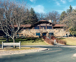
Theodore Wirth Park is the regional park managed by the Minneapolis Park and Recreation Board. The park land is shared by Minneapolis and the neighboring suburb of Golden Valley. Formally named Theodore Wirth Regional Park, it includes two golf courses, Wirth Lake, Birch Pond, cross-country ski trails, mountain biking trails, snow tubing hills, and other amenities. It forms a significant portion of the Grand Rounds Scenic Byway, linking the Chain of Lakes area with the Victory Memorial Parkway.

Lake Hiawatha is located just north of Lake Nokomis in Minneapolis, Minnesota. It was purchased by the Minneapolis Park and Recreation Board in 1922 for $550,000. At that time the lake was a marsh known as Rice Lake, but over four years, the park system transformed the wetland into a lake surrounded by a park.

Lake Street is a major east-west thoroughfare between 29th and 31st streets in Minneapolis, Minnesota United States. From its western most end at the city's limits, Lake Street reaches the Chain of Lakes, passing over a small channel linking Bde Maka Ska and Lake of the Isles, and at its eastern most end it reaches the Mississippi River. In May 2020, the Lake Street corridor suffered extensive damage during local unrest over the murder of George Floyd. In August of the same year, city officials designated East Lake Street as one of seven cultural districts to promote racial equity, preserve cultural identity, and promote economic growth.

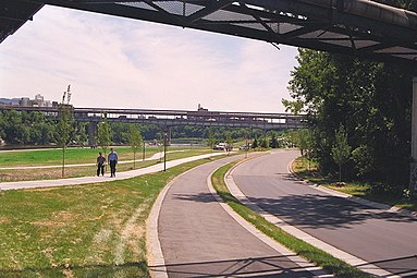
The Midtown Greenway is a 5.7-mile (9.2 km) rail trail in Minneapolis, Minnesota that follows the path of an abandoned route of the Milwaukee Road railway. It is considered under segregated cycle facilities.
Lyndale Park is a Minneapolis city park on the northeast side of Lake Harriet. It is next to Lakewood Cemetery, southeast of Bde Maka Ska. It is part of an enormous greenspace circling through Minneapolis called the Grand Rounds Scenic Byway, and is one of the seven districts within, called the Chain of Lakes. The other six districts within Grand Rounds are the Downtown Riverfront, Mississippi River, Minnehaha, Theodore Wirth, Victory Memorial Parkway, and Northeast. Managed by the Minneapolis Park and Recreation Board, the 53-mile (85 km) parkway system has numerous parks and parkways, lakes, streams and creeks, the Mississippi River, and the 53-foot (16 m) high Minnehaha Falls. The 6,400-acre (26 km2) park system is designed so that every home in Minneapolis is within six blocks of green space.

Lind-Bohanon is a northern neighborhood within the Camden community in Minneapolis.

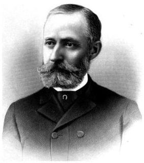
Theodore Wirth (1863–1949) was instrumental in designing the Minneapolis system of parks. Swiss-born, he was widely regarded as the dean of the local parks movement in America. The various titles he was given included administrator of parks, horticulturalist, and park planner. Before emigrating to America in 1888, he worked as a florist and landscaper in Zurich, London, and Paris. He married Leonie Mense, the daughter of his employer in Glen Cove, Long Island, before taking a job as superintendent of parks in Hartford, Connecticut in 1896, where he developed the first municipal rose garden in the country.
Minneapolis is the largest city in the state of Minnesota in the United States, and the county seat of Hennepin County.
Charles Morgridge Loring was an American businessman, miller and publicist. Raised in Maine to be a sea captain, Loring instead became a civic leader in Minneapolis, Minnesota where he was a wealthy flour miller and in Riverside, California where he helped to build the first city hall. He was a popular and generous man who enjoyed many friendships and business associations.
The Minneapolis Park and Recreation Board (MPRB) is an independent park district that owns, maintains, and programs activities in public parks in Minneapolis, Minnesota, United States. It has 500 full-time and 1,300 part-time employees and an $111 million operating and capital budget.

Winchell Trail is a five-mile (8 km) round trip, pedestrian-only trail in Minneapolis, Minnesota, United States, that runs along the west side of the Mississippi River between Franklin Avenue South and East 44th Street. Popular with bird watchers and naturalists, the rustic trail provides Upper Mississippi River gorge access and views. The trail is separate from the adjacent multi-use bicycle path, taking hikers past sandy beaches, an oak savanna restoration project, and the floodplain forest. The trail has multiple access points and the section from East 38th Street to East 44th Street is paved. Described as moderate and for all hiking skill levels, the out-and-back Winchell Trail has total elevation gain of 501 feet (153 m). Portions of the trail can be hiked in near solitude as its age and general destitute make it a widely forgotten place to explore.

Minnehaha Trail is a 1.5-mile (2.4 km) paved, multi-use trail in Minneapolis, Minnesota, United States, that connects Minnehaha Regional Park and Fort Snelling State Park – two of the most popular recreation destinations in the Twin Cities metro area. The trail is considered a segment of a longer, loosely connected bicycle route system along the Mississippi River. Users of Minnehaha Trail traverse under a forest canopy. The trail received local recognition for its natural beauty, but it was criticized for its worn pavement and lack of signage.

Minnehaha Falls Lower Glen Trail is a popular hiking route in Minneapolis, Minnesota, United States. The 2.1-mile (3.4 km) trail loop begins and ends at the base of the iconic Minnehaha Falls. Hikers follow natural trails and elevated boardwalks through a sedimentary rock glen carved by Minnehaha Creek to its confluence with the Mississippi River where there is a sandy beach. Portions of the trail loop are rated moderate to challenging in difficulty.

Minneapolis is often considered one of the top biking and walking cities in the United States due to its vast network of trails and dedicated pedestrian areas. In 2020, Walk Score rated Minneapolis as 13th highest among cities over 200,000 people. Some bicycling ratings list Minneapolis at the top of all United States cities, while others list Minneapolis in the top ten. There are over 80 miles (130 km) of paved, protected pathways in Minneapolis for use as transportation and recreation. The city's Grand Rounds National Scenic Byway parkway system accounts for the vast majority of the city's shared-use paths at approximately 50 miles (80 km) of dedicated biking and walking areas. By 2008, other city, county, and park board areas accounted for approximately 30 miles (48 km) of additional trails, for a city-wide total of approximately 80 miles (130 km) of protected pathways. The network of shared biking and walking paths continued to grow into the late 2010s with the additions of the Hiawatha LRT Trail gap remediation, Min Hi Line pilot projects, and Samatar Crossing. The city also features several natural-surface hiking trails, mountain-biking paths, groomed cross-country ski trails in winter, and other pedestrian walkways.
Minnesota Scenic Byways are a system of roads in the U.S. state of Minnesota which pass through areas of scenic, cultural, or recreational significance. There are currently 22 scenic byways in the system with a total length of 2,948 miles (4,744 km). Eight of these byways are also designated as National Scenic Byways, and the North Shore Scenic Drive is further designated as an All-American Road.

Mississippi Gorge Regional Park is a regional park along the east and west bluffs of the Mississippi River in the cities of Minneapolis and Saint Paul in the U.S. state of Minnesota. The two-city park area is between Mississippi river miles 848 and 852, from just south of Northern Pacific Bridge Number 9 to just north of Minnehaha Regional Park, and lies within the Mississippi National River and Recreation Area. The park area protects scenic and natural areas of the Mississippi River gorge, the only true gorge along the entire length of the 2,320-mile (3,730 km) river.