Grass Range, Montana

Last updated

Grass Range, Montana
Fergus County Montana Incorporated and Unincorporated areas Grass Range Highlighted.svg
Location of Grass Range, Montana
Coordinates: 47°1′34″N108°48′12″W / 47.02611°N 108.80333°W / 47.02611; -108.80333
Country United States
State Montana
County Fergus
Area
[1]
  Total0.14 sq mi (0.36 km2)
  Land0.14 sq mi (0.36 km2)
  Water0.00 sq mi (0.00 km2)
Elevation
[2]
3,484 ft (1,062 m)
Population
 (2020)
  Total110
  Density785.71/sq mi (303.71/km2)
Time zone UTC-7 (Mountain (MST))
  Summer (DST) UTC-6 (MDT)
ZIP codes
59032, 59441
Area code 406
FIPS code 30-32575
GNIS feature ID0771931 [2]

Grass Range is a town in Fergus County, Montana, United States. The population was 110 in both the 2010 census and 2020 census. [3]

Contents

History

A post office has been in operation in Grass Range since 1883. [4] The town was probably named from the fact livestock graze here. [5]

Geography

Grass Range is located at 47°1′34″N108°48′12″W / 47.02611°N 108.80333°W / 47.02611; -108.80333 (47.025980, -108.803391). [6] U.S. Route 87 passes through town. It is 31 miles from Lewistown.

According to the United States Census Bureau, the town has a total area of 0.15 square miles (0.39 km2), all land. [7]

Climate

Climate data for Grass Range, Montana (1991–2020)
MonthJanFebMarAprMayJunJulAugSepOctNovDecYear
Mean daily maximum °F (°C)37.2
(2.9)
38.8
(3.8)
48.2
(9.0)
57.1
(13.9)
66.0
(18.9)
74.0
(23.3)
83.3
(28.5)
82.7
(28.2)
72.6
(22.6)
58.9
(14.9)
46.3
(7.9)
37.7
(3.2)
58.6
(14.8)
Daily mean °F (°C)25.7
(−3.5)
27.2
(−2.7)
35.6
(2.0)
43.9
(6.6)
52.8
(11.6)
60.7
(15.9)
68.1
(20.1)
67.3
(19.6)
58.0
(14.4)
46.1
(7.8)
34.5
(1.4)
26.4
(−3.1)
45.5
(7.5)
Mean daily minimum °F (°C)14.2
(−9.9)
15.7
(−9.1)
23.0
(−5.0)
30.7
(−0.7)
39.5
(4.2)
47.4
(8.6)
52.9
(11.6)
51.9
(11.1)
43.5
(6.4)
33.4
(0.8)
22.7
(−5.2)
15.2
(−9.3)
32.5
(0.3)
Average precipitation inches (mm)0.68
(17)
0.51
(13)
0.87
(22)
1.85
(47)
3.39
(86)
3.22
(82)
1.70
(43)
1.67
(42)
1.46
(37)
1.25
(32)
0.71
(18)
0.55
(14)
17.86
(453)
Average snowfall inches (cm)8.7
(22)
7.8
(20)
9.2
(23)
4.8
(12)
0.9
(2.3)
0.0
(0.0)
0.0
(0.0)
0.0
(0.0)
0.1
(0.25)
3.4
(8.6)
6.4
(16)
8.8
(22)
50.1
(126.15)
Source: NOAA [8]

Demographics

Historical population
CensusPop.Note
1920 262
1930 212−19.1%
1940 206−2.8%
1950 23413.6%
1960 222−5.1%
1970 181−18.5%
1980 139−23.2%
1990 15914.4%
2000 149−6.3%
2010 110−26.2%
2020 1100.0%
U.S. Decennial Census [9] [3]

2010 census

As of the census [10] of 2010, there were 110 people, 61 households, and 29 families living in the town. The population density was 733.3 inhabitants per square mile (283.1/km2). There were 82 housing units at an average density of 546.7 per square mile (211.1/km2). The racial makeup of the town was 99.1% White and 0.9% from two or more races.

There were 61 households, of which 16.4% had children under the age of 18 living with them, 39.3% were married couples living together, 6.6% had a female householder with no husband present, 1.6% had a male householder with no wife present, and 52.5% were non-families. 47.5% of all households were made up of individuals, and 23% had someone living alone who was 65 years of age or older. The average household size was 1.80 and the average family size was 2.48.

The median age in the town was 55.5 years. 13.6% of residents were under the age of 18; 2.7% were between the ages of 18 and 24; 16.3% were from 25 to 44; 37.3% were from 45 to 64; and 30% were 65 years of age or older. The gender makeup of the town was 53.6% male and 46.4% female.

2000 census

As of the census [11] of 2000, there were 149 people, 67 households, and 42 families living in the town. The population density was 1,022.9 inhabitants per square mile (394.9/km2). There were 80 housing units at an average density of 549.2 per square mile (212.0/km2). The racial makeup of the town was 100.00% White.

There were 67 households, out of which 25.4% had children under the age of 18 living with them, 50.7% were married couples living together, 6.0% had a female householder with no husband present, and 37.3% were non-families. 32.8% of all households were made up of individuals, and 14.9% had someone living alone who was 65 years of age or older. The average household size was 2.22 and the average family size was 2.81.

In the town, the population was spread out, with 21.5% under the age of 18, 6.0% from 18 to 24, 22.1% from 25 to 44, 36.2% from 45 to 64, and 14.1% who were 65 years of age or older. The median age was 45 years. For every 100 females there were 101.4 males. For every 100 females age 18 and over, there were 108.9 males.

The median income for a household in the town was $19,375, and the median income for a family was $30,625. Males had a median income of $18,125 versus $0 for females. The per capita income for the town was $10,939. There were 37.5% of families and 44.4% of the population living below the poverty line, including 82.4% of under eighteens and 16.0% of those over 64.

Education

Grass Range Public Schools educates students from kindergarten through 12th grade. [12] They are known as the Rangers. [13] Grass Range High School had 19 students in 2021. [14]

Notable people

See also

Related Research Articles

<span class="mw-page-title-main">Lima, Montana</span> Town in Montana, United States

Lima is a town in Beaverhead County, Montana, United States. As of the 2020 census, the population was 212.

<span class="mw-page-title-main">Lodge Grass, Montana</span> Town in Montana, United States

Lodge Grass is a town in Big Horn County, Montana, United States. The population was 441 at the 2020 census.

<span class="mw-page-title-main">Fromberg, Montana</span> Town in Carbon County, Montana, United States

Fromberg is a town in Carbon County, Montana, United States. As of the 2020 census, the population of the town was 392.

<span class="mw-page-title-main">Simms, Montana</span> CDP in Montana, United States

Simms is a census-designated place (CDP) in Cascade County, Montana, United States. The population was 354 at the 2010 census. It is part of the Great Falls, Montana Metropolitan Statistical Area.

<span class="mw-page-title-main">Sun Prairie, Montana</span> CDP in Montana, United States

Sun Prairie is a census-designated place (CDP) in Cascade County, Montana, United States. The population was 1,630 at the 2010 census. It is part of the Great Falls Metropolitan Statistical Area and may have evolved as a remote suburb of Great Falls.

<span class="mw-page-title-main">Winifred, Montana</span> Town in Montana, United States

Winifred is a small town in rural north-central Fergus County, Montana, United States. It was founded in 1913 and provides services for its region's populace. The town population was 172 at the 2020 census. The current mayor is Travis Willson.

<span class="mw-page-title-main">Jordan, Montana</span> Town in Montana, United States

Jordan is a town in and the county seat of Garfield County, Montana, United States. The population was 356 at the 2020 census. It is Garfield County's only incorporated community.

<span class="mw-page-title-main">Lavina, Montana</span> Town in Montana, United States

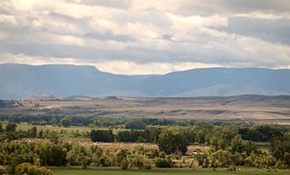
Lavina is a town in Golden Valley County, Montana, United States. The population was 136 at the 2020 census. The town is situated on the north bank of the Musselshell River.

<span class="mw-page-title-main">Ryegate, Montana</span> Town in Montana, United States

Ryegate is a town in, and the county seat of, Golden Valley County, Montana, United States. The population was 223 at the 2020 census. Ryegate is situated on the north bank of the Musselshell River.

<span class="mw-page-title-main">Drummond, Montana</span> Town in Montana, United States

Drummond is a town in Granite County, Montana, United States. The population was 272 at the 2020 census.

<span class="mw-page-title-main">Superior, Montana</span> Town in Montana, United States

Superior is a town in, and the county seat of, Mineral County, Montana, United States. The population was 830 at the 2020 census.

<span class="mw-page-title-main">Melstone, Montana</span> Town in Montana, United States

Melstone is a rural small town in far eastern Musselshell County, Montana, United States, along U.S. Route 12. The population was 126 at the 2020 census. The town was established in 1908 as a base for operating crews on the Chicago, Milwaukee, St. Paul and Pacific Railroad, then under construction in Montana. Although the railroad was abandoned in 1980, Melstone survives as a community center for farmers and ranchers in the lower Musselshell River valley.

<span class="mw-page-title-main">Roundup, Montana</span> City in Montana, United States

Roundup is a city in and the county seat of Musselshell County, Montana, United States. The population was 1,742 during the 2020 census.

<span class="mw-page-title-main">Westby, Montana</span> Town in Montana, United States

Westby is a town in Sheridan County, Montana, United States. The population was 167 at the 2020 census.

<span class="mw-page-title-main">Broadview, Montana</span> Town in Montana, United States

Broadview is a town in Yellowstone County, Montana, United States. The population was 139 at the 2020 census.

<span class="mw-page-title-main">Plevna, Montana</span> Town in Montana, United States

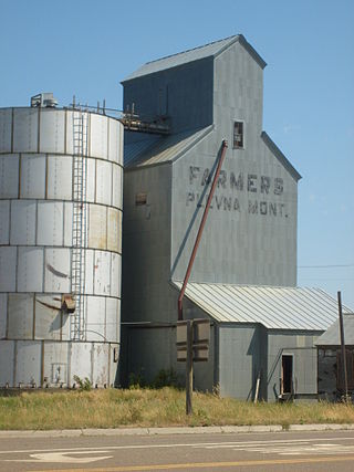
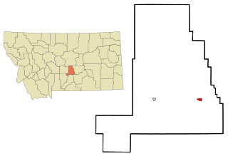
Plevna is a town in Fallon County, Montana, United States. The population was 179 at the 2020 census.

<span class="mw-page-title-main">Stanford, Montana</span> Town in Montana, United States

Stanford is a town in and the county seat of Judith Basin County, Montana, United States. The population was at 403 as of the 2020 census.

<span class="mw-page-title-main">Grass Valley, Oregon</span> City in Oregon, United States

Grass Valley is a city in Sherman County, Oregon, United States. The population was 164 at the 2010 census.

<span class="mw-page-title-main">Montana, Wisconsin</span> Town in Wisconsin, United States

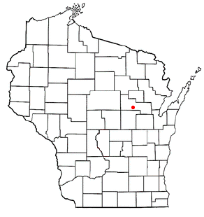
Montana is a town in Buffalo County in the U.S. state of Wisconsin. The population was 284 at the 2010 census. The community of Montana is located in the town.

<span class="mw-page-title-main">Pella, Wisconsin</span> Town in Wisconsin, United States

Pella is a town in Shawano County, Wisconsin, United States. The population was 877 at the 2000 census. The unincorporated community of Leopolis is located partially within the town. There is a census-designated place also called Pella in the town.

References

  1. "ArcGIS REST Services Directory". United States Census Bureau. Retrieved September 5, 2022.
  2. 1 2 U.S. Geological Survey Geographic Names Information System: Grass Range, Montana
  3. 1 2 "U.S. Census website". United States Census Bureau . Retrieved November 2, 2021.
  4. "Fergus County". Jim Forte Postal History. Retrieved April 27, 2015.
  5. "Origins of Names on Milwaukee". Roundup Record-Tribune & Winnett Times. August 22, 1940. p. 6. Retrieved April 27, 2015.
  6. "US Gazetteer files: 2010, 2000, and 1990". United States Census Bureau. February 12, 2011. Retrieved April 23, 2011.
  7. "US Gazetteer files 2010". United States Census Bureau. Archived from the original on January 25, 2012. Retrieved December 18, 2012.
  8. "NOAA NCEI U.S. Climate Normals Quick Access". NOAA. Retrieved July 1, 2022.
  9. "Census of Population and Housing". Census.gov. Retrieved June 4, 2015.
  10. "U.S. Census website". United States Census Bureau . Retrieved December 18, 2012.
  11. "U.S. Census website". United States Census Bureau . Retrieved January 31, 2008.
  12. "Grass Range Public Schools". Grass Range Public Schools. Retrieved April 16, 2021.
  13. "Member Schools". Montana High School Association. Retrieved April 19, 2021.
  14. "Grass Range High School". Niche. Retrieved April 16, 2021.

Commons-logo.svg Media related to Grass Range, Montana at Wikimedia Commons