Lewistown Heights, Montana

Last updated
Lewistown Heights, Montana
Fergus County Montana Incorporated and Unincorporated areas Lewistown Heights Highlighted.svg
Location of Lewistown Heights, Montana
Coordinates: 47°4′32″N109°27′21″W / 47.07556°N 109.45583°W / 47.07556; -109.45583 Coordinates: 47°4′32″N109°27′21″W / 47.07556°N 109.45583°W / 47.07556; -109.45583
Country United States
State Montana
County Fergus
Area
[1]
  Total2.36 sq mi (6.10 km2)
  Land2.36 sq mi (6.10 km2)
  Water0.00 sq mi (0.00 km2)
Elevation
3,947 ft (1,203 m)
Population
 (2020)
  Total364
  Density154.43/sq mi (59.62/km2)
Time zone UTC-7 (Mountain (MST))
  Summer (DST) UTC-6 (MDT)
Area code 406
FIPS code 30-43400
GNIS feature ID1853184

Lewistown Heights is an unincorporated area and census-designated place (CDP) in Fergus County, Montana, United States. The population was 407 at the 2010 census, [2] up from 365 in 2000.

Contents

Geography

Lewistown Heights is located at 47°4′32″N109°27′21″W / 47.07556°N 109.45583°W / 47.07556; -109.45583 (47.075668, -109.455739), [3] northwest of Lewistown, the county seat. It is bordered to the south by Valach Road, to the east by Joyland Road, to the north by Wolverine Creek Road, and to the west by Wolverine Creek. Downtown Lewistown is 1.5 miles (2.4 km) to the southeast.

According to the United States Census Bureau, the CDP has a total area of 2.4 square miles (6.1 km2), all land. [2]

Demographics

Historical population
CensusPop.Note
2020 364
U.S. Decennial Census [4]

As of the census [5] of 2000, there were 365 people, 138 households, and 93 families residing in the CDP. The population density was 155.6 inhabitants per square mile (60.1/km2). There were 149 housing units at an average density of 63.5 per square mile (24.5/km2). The racial makeup of the CDP was 94.52% White, 1.64% African American, 1.37% Native American, 1.64% from other races, and 0.82% from two or more races. Hispanic or Latino of any race were 1.64% of the population.

There were 138 households, out of which 32.6% had children under the age of 18 living with them, 57.2% were married couples living together, 5.8% had a female householder with no husband present, and 31.9% were non-families. 18.8% of all households were made up of individuals, and 8.7% had someone living alone who was 65 years of age or older. The average household size was 2.64 and the average family size was 3.13.

In the CDP, the population was spread out, with 29.0% under the age of 18, 6.0% from 18 to 24, 28.8% from 25 to 44, 24.7% from 45 to 64, and 11.5% who were 65 years of age or older. The median age was 37 years. For every 100 females, there were 92.1 males. For every 100 females age 18 and over, there were 107.2 males.

The median income for a household in the CDP was $31,154, and the median income for a family was $34,063. Males had a median income of $28,382 versus $13,036 for females. The per capita income for the CDP was $11,274. About 9.3% of families and 15.6% of the population were below the poverty line, including 12.7% of those under age 18 and none of those age 65 or over.

Related Research Articles

<span class="mw-page-title-main">Sawmill, Arizona</span> CDP in Apache County, Arizona

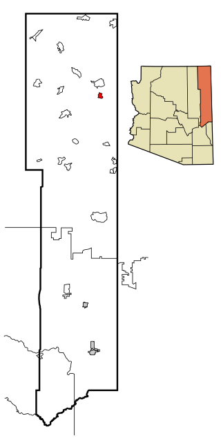
Sawmill is a census-designated place (CDP) in Apache County, Arizona, United States. Sawmill is a part of Fort Defiance Agency, which is on the Navajo Nation. The population was 748 at the 2010 census. It is named after and developed around a sawmill. A trading post has been present since 1907.

<span class="mw-page-title-main">Tsaile, Arizona</span> Census-designated place in Arizona, United States

Tsaile is a census-designated place (CDP) in Apache County, Arizona, United States, on the Navajo Nation. The population was 1,205 at the 2010 census.

<span class="mw-page-title-main">Greasewood, Arizona</span> CDP in Navajo County, Arizona

Greasewood is a census-designated place (CDP) in Navajo County, Arizona, United States. The population was 547 at the 2010 census.

<span class="mw-page-title-main">Canyondam, California</span> Census-designated place in California, United States

Canyondam is a census-designated place (CDP) in Plumas County, California, United States. Canyondam is located near the dam that forms Lake Almanor, 6.25 miles (10.1 km) east-southeast of Almanor. The population was 31 as of the 2010 census, down from 37 as of the 2000 census. On August 6, 2021, the community was destroyed in the Dixie Fire.

<span class="mw-page-title-main">Preston Heights, Illinois</span> Census-designated place in Illinois, United States

Preston Heights is a census-designated place (CDP) in Will County, Illinois, United States. As of the 2020 census, the CDP population was 2,898.

<span class="mw-page-title-main">Beaver Creek, Montana</span> Census-designated place in Montana, United States

Beaver Creek is a census-designated place (CDP) in Hill County, Montana, United States. The population was 271 at the 2010 census.

<span class="mw-page-title-main">Holiday Heights, New Jersey</span> Census-designated place in New Jersey, United States

Holiday Heights is an unincorporated community and census-designated place (CDP) located within Berkeley Township, in Ocean County, New Jersey, United States. As of the 2010 United States Census, the CDP's population was 2,099.

Jefferson Heights is a hamlet and census-designated place (CDP) in Greene County, New York, United States. The population was 1,122 at the 2020 census.

<span class="mw-page-title-main">Day Heights, Ohio</span> Census-designated place in Ohio, United States

Day Heights is a census-designated place (CDP) in Clermont County, Ohio, United States. The population was 2,625 at the 2020 census.

<span class="mw-page-title-main">Perry Heights, Ohio</span> CDP in Ohio, United States

Perry Heights is a census-designated place (CDP) in Stark County, Ohio, United States. The population was 8,900 at the 2000 census. It is part of the Canton-Massillon, OH Metropolitan Statistical Area. It was originally known as Genoa.

<span class="mw-page-title-main">Reedsville, Pennsylvania</span> Census-designated place in Pennsylvania, United States

Reedsville is a census-designated place (CDP) in the Kishacoquillas Valley of Mifflin County, Pennsylvania, United States. The population was 641 at the 2010 census. Reedsville has a high Amish population.

<span class="mw-page-title-main">Palmer Heights, Pennsylvania</span> Place in Pennsylvania, United States

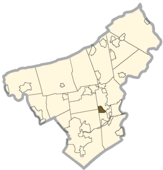
Palmer Heights is a census-designated place (CDP) in Palmer Heights, Pennsylvania. The population of Palmer Heights was 3,762 at the 2010 census. Palmer Heights is part of the Lehigh Valley, which had a population of 861,899 and was the 68th most populous metropolitan area in the U.S. as of the 2020 census.

<span class="mw-page-title-main">Shenandoah Heights, Pennsylvania</span> CDP in Pennsylvania, United States

Shenandoah Heights is a census-designated place (CDP) in Schuylkill County, Pennsylvania. The population was 1,298 at the 2000 census.

Woodland Heights is a census-designated place (CDP) in Venango County, Pennsylvania, United States. The population was 1,402 at the 2000 census.

<span class="mw-page-title-main">Ashland Heights, South Dakota</span> CDP in South Dakota, United States

Ashland Heights is a census-designated place (CDP) and unincorporated community in Pennington County, South Dakota, United States. The population was 678 at the 2020 census.

<span class="mw-page-title-main">Tselakai Dezza, Utah</span> CDP in Utah, United States

Tselakai Dezza is a census-designated place (CDP) in San Juan County, Utah, United States. The population was 103 at the 2000 census.

<span class="mw-page-title-main">Ocean City, Washington</span> Census-designated place in Washington, United States

Ocean City is a census-designated place (CDP) in Grays Harbor County, Washington, United States. The population was 200 at the 2010 census.

<span class="mw-page-title-main">Maple Heights-Lake Desire, Washington</span> Census-designated place in Washington, United States

Maple Heights-Lake Desire is a census-designated place (CDP) in King County, Washington, United States. At the 2010 census, the population was 3,152.

<span class="mw-page-title-main">Prairie Ridge, Washington</span> CDP in Washington, United States

Prairie Ridge is a census-designated place (CDP) in Pierce County, Washington, United States. The population was 12,288 at the 2020 census.

<span class="mw-page-title-main">Three Lakes, Washington</span> CDP in Washington, United States

Three Lakes is a census-designated place (CDP) in Snohomish County, Washington, United States. The population was 3,184 at the 2010 census.

References

  1. "ArcGIS REST Services Directory". United States Census Bureau. Retrieved September 5, 2022.
  2. 1 2 "Geographic Identifiers: 2010 Census Summary File 1 (G001), Lewistown Heights CDP, Montana". American FactFinder. U.S. Census Bureau. Archived from the original on February 13, 2020. Retrieved June 5, 2016.
  3. "US Gazetteer files: 2010, 2000, and 1990". United States Census Bureau. 2011-02-12. Retrieved 2011-04-23.
  4. "Census of Population and Housing". Census.gov. Retrieved June 4, 2016.
  5. "U.S. Census website". United States Census Bureau . Retrieved 2008-01-31.