
The Nearctic realm is one of the eight biogeographic realms constituting the Earth's land surface.
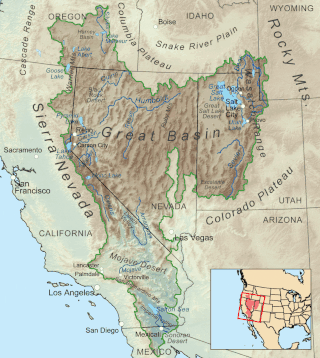
The Great Basin is the largest area of contiguous endorheic watersheds, those with no outlets to the ocean, in North America. It spans nearly all of Nevada, much of Utah, and portions of California, Idaho, Oregon, Wyoming, and Baja California. It is noted for both its arid climate and the basin and range topography that varies from the North American low point at Badwater Basin in Death Valley to the highest point of the contiguous United States, less than 100 miles (160 km) away at the summit of Mount Whitney. The region spans several physiographic divisions, biomes, ecoregions, and deserts.

The Sonoran Desert is a hot desert in North America and ecoregion that covers the northwestern Mexican states of Sonora, Baja California, and Baja California Sur, as well as part of the southwestern United States. It is the hottest desert in both Mexico and the United States. It has an area of 260,000 square kilometers (100,000 sq mi).

The Great Basin Desert is part of the Great Basin between the Sierra Nevada and the Wasatch Range. The desert is a geographical region that largely overlaps the Great Basin shrub steppe defined by the World Wildlife Fund, and the Central Basin and Range ecoregion defined by the U.S. Environmental Protection Agency and United States Geological Survey. It is a temperate desert with hot, dry summers and snowy winters. The desert spans large portions of Nevada and Utah, and extends into eastern California. The desert is one of the four biologically defined deserts in North America, in addition to the Mojave, Sonoran, and Chihuahuan Deserts.
A phytochorion, in phytogeography, is a geographic area with a relatively uniform composition of plant species. Adjacent phytochoria do not usually have a sharp boundary, but rather a soft one, a transitional area in which many species from both regions overlap. The region of overlap is called a vegetation tension zone.

The ecology of California can be understood by dividing the state into a number of ecoregions, which contain distinct ecological communities of plants and animals in a contiguous region. The ecoregions of California can be grouped into four major groups: desert ecoregions, Mediterranean ecoregions, forested mountains, and coastal forests.

The ecoregions of Madagascar, as defined by the World Wildlife Fund, include seven terrestrial, five freshwater, and two marine ecoregions. Madagascar's diverse natural habitats harbour a rich fauna and flora with high levels of endemism, but most ecoregions suffer from habitat loss.

The Boreal Kingdom or Holarctic Kingdom (Holarctis) is a floristic kingdom identified by botanist Ronald Good, which includes the temperate to Arctic portions of North America and Eurasia. Its flora is inherited from the ancient supercontinent of Laurasia. However, parts of the floristic kingdom were glaciated during the Pleistocene and as a consequence have a very young flora. Cenozoic relicts found refuge in the southern and mountainous parts of the kingdom, especially in the Eastern Asiatic Region and southern North American Atlantic Region.
The California Floristic Province (CFP) is a floristic province with a Mediterranean-type climate located on the Pacific Coast of North America with a distinctive flora similar to other regions with a winter rainfall and summer drought climate like the Mediterranean Basin. This biodiversity hotspot is known for being the home of the Sierran giant sequoia tree and its close relative the coast redwood. In 1996, the Province was designated as a biodiversity hotspot allowing it to join ranks among 33 other areas in the world with many endemic species. To be named a biodiversity hotspot, an area has to contain species and plant life that cannot be found anywhere else in the world. The California Floristic Province is home to over 3,000 species of vascular plants, 60% of which are endemic to the province.

The Central Mexican Plateau, also known as the Mexican Altiplano, is a large arid-to-semiarid plateau that occupies much of northern and central Mexico. Averaging 1,825 m (5,988 ft) above sea level, it extends from the United States border in the north to the Trans-Mexican Volcanic Belt in the south, and is bounded by the Sierra Madre Occidental and Sierra Madre Oriental to the west and east, respectively.

The North American Atlantic Region is a floristic region within the Holarctic Kingdom identified by Armen Takhtajan and Robert F. Thorne, spanning from the Atlantic and Gulf coasts to the Great Plains and comprising a major part of the United States and southeastern portions of Canada. It is bordered by the Circumboreal floristic region in the north, by the Rocky Mountain and Madrean floristic regions in the west and by the Caribbean floristic region of the Neotropical Kingdom in the south of Florida. The flora of the region comprises two endemic monotypic families, Hydrastidaceae and Leitneriaceae, and is characterized by about a hundred of endemic genera. The degree of species endemism is very high, many species are Tertiary relicts, which survived the Wisconsin glaciation and are now concentrated in the Appalachians and the Ozarks. A number of genera are shared only with the Canadian floristic province of the Circumboreal region. Moreover, as has long been noted, a large number of relict genera are shared with the relatively distant Eastern Asiatic Region and sometimes Southeast Asia. R. F. Thorne counted at least 74 genera restricted to eastern North America and Asia. The fossil record indicates that during the Tertiary period a warm temperate zone extended across much of the Northern Hemisphere, linking America to Asia.

The Rocky Mountain Floristic Region is a floristic region within the Holarctic Kingdom in western North America delineated by Armen Takhtajan and Robert F. Thorne. The region extends from Kodiak Island in Alaska to the San Francisco Bay Area and Sierra Nevada in California. It consists of two provinces, the Vancouverian, which comprises the coastal part of the region for its entire length, including the Pacific Coast Ranges, and the Rocky Mountain, which includes the Rocky Mountains and associated ranges. There are no endemic plant families in the region but many endemic genera and species.

The Madrean Region is a floristic region within the Holarctic Kingdom in North America, as delineated by Armen Takhtajan and Robert F. Thorne. It occupies arid or semiarid areas in the southwestern United States and northwestern Mexico and is bordered by the Rocky Mountain Floristic Region and North American Atlantic Region of the Holarctic Kingdom in the north and in the east, Caribbean Region of the Neotropical Kingdom in the south.

The Paleotropical Kingdom (Paleotropis) is a floristic kingdom composed of the tropical areas of Africa, Asia and Oceania, as proposed by Ronald Good and Armen Takhtajan. Part of its flora is inherited from the ancient supercontinent of Gondwana or exchanged later. These Gondwanan lineages are related to those in the Neotropical Kingdom, composed of the tropical areas of Central and South America. Flora from the Paleotropical Kingdom influenced the tropical flora of the Australian Kingdom. The kingdom is subdivided into five floristic subkingdoms according to Takhtajan and about 13 floristic regions. In this article the floristic subkingdoms and regions are given as delineated by Takhtajan.

The Eastern Cascades Slopes and Foothills ecoregion is a Level III ecoregion designated by the United States Environmental Protection Agency (EPA) in the U.S. states of Oregon, Washington, and California. In the rain shadow of the Cascade Range, the eastern side of the mountains experiences greater temperature extremes and receives less precipitation than the west side. Open forests of ponderosa pine and some lodgepole pine distinguish this region from the Cascades ecoregion, where hemlock and fir forests are more common, and from the lower, drier ecoregions to the east, where shrubs and grasslands are predominant. The vegetation is adapted to the prevailing dry, continental climate and frequent wildfire. Volcanic cones and buttes are common in much of the region.

The Blue Mountains ecoregion is a Level III ecoregion designated by the United States Environmental Protection Agency (EPA) in the Pacific Northwest, mainly in the state of Oregon, with small areas over the state border in Idaho and southeastern Washington. It is also contiguous with the World Wildlife Fund's Blue Mountain forests ecoregion.

The Snake River Plain ecoregion is a Level III ecoregion designated by the United States Environmental Protection Agency (EPA) in the U.S. states of Idaho and Oregon. It follows the Snake River across Idaho, stretching roughly 400 miles (640 km) from the Wyoming border to Eastern Oregon in the xeric intermontane west. Characterized by plains and low hills, it is considerably lower and less rugged than surrounding ecoregions. Many of the alluvial valleys bordering the Snake River are used for agriculture. Where irrigation water and soil depth are sufficient, sugar beets, potatoes, alfalfa, small grains, and vegetables are grown. Elsewhere, livestock grazing is widespread. Cattle feedlots and dairy operations are found locally.

The Northern Basin and Range ecoregion is a Level III ecoregion designated by the United States Environmental Protection Agency (EPA) in the U.S. states of Oregon, Idaho, Nevada, Utah, and California. It contains dissected lava plains, rolling hills, alluvial fans, valleys, and scattered mountain ranges in the northern part of the Great Basin. Although arid, the ecoregion is higher and cooler than the Snake River Plain to the north and has more available moisture and a cooler climate than the Central Basin and Range to the south. Its southern boundary is determined by the highest shoreline of Pleistocene Lake Bonneville, which once inundated the Central Basin and Range. The western part of the region is internally drained; its eastern stream network drains to the Snake River system.
Great Basin may refer to:
