
Mongolia is a landlocked country in East Asia, located between China and Russia. The terrain is one of mountains and rolling plateaus, with a high degree of relief. The total land area of Mongolia is 1,564,116 square kilometres. Overall, the land slopes from the high Altai Mountains of the west and the north to plains and depressions in the east and the south. The Khüiten Peak in extreme western Mongolia on the Chinese border is the highest point. The lowest point is at 560 m (1,840 ft), is the Hoh Nuur or lake Huh. The country has an average elevation of 1,580 m (5,180 ft).

Uvs Lake is a highly saline lake in an endorheic basin—Uvs Nuur Basin, primarily in Mongolia with a smaller part in Russia. It is the largest lake in Mongolia by surface area, covering 3,350 km2 at 759 m above sea level. The northeastern tip of the lake is situated in the Tuva Republic of the Russian Federation. The largest settlement near the lake is Ulaangom. This shallow and very saline body of water is a remainder of a huge saline sea which covered a much larger area several thousand years ago.
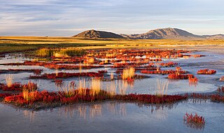
Uvs Lake Basin is an endorheic basin located on the territorial border of Mongolia and Tuva, a republic of the Russian Federation. The basin is part of the Central Asian Internal Drainage Basin and is named after Uvs Lake, a large saline lake situated in the western part of its drainage basin, and is one of the last remnants of the mammoth steppes. Uvs Lake is a shallow lake with an area of 3,350 km2 (1,290 sq mi). Its entire basin, which includes several smaller lakes, is 70,000 km2 (27,000 sq mi).

The Great Lakes Depression, also called the Great Lakes' Hollow, is a large semi-arid depression in Mongolia that covers parts of the Uvs, Khovd, Bayan-Ölgii, Zavkhan and Govi-Altai aimags. Bounded by the Altai in the West, Khangai in the East and Tannu-Ola Mountains in the North, it covers the area of over 100,000 km2 (39,000 sq mi) with elevations from 750 to 2,000 m (2,460–6,560 ft).

The wildlife of Mongolia consists of flora, fauna and funga found in the harsh habitats dictated by the diverse climatic conditions found throughout the country. In the north, there are salty marshes and fresh-water sources. The centre has desert steppes. In the south, there are semi deserts as well as the hot Gobi desert in the south, the fifth-largest desert in the world.
The Altai-Sayan region is an area of Inner Asia proximate to the Altai Mountains and the Sayan Mountains, near to where Russia, China, Mongolia and Kazakhstan come together. This region is one of the world centers of temperate plant diversity. Its biological, landscape, historical, cultural and religious diversity is unique. 3,726 species of vascular plants are registered in the region including 700 threatened or rare species, 317 of which are endemic; fauna consists of 680 species, 6% of which are endemic. Its ecosystem is comparatively unchanged since the last ice age, and it is the host of endangered species that include the saiga, nerpa, and snow leopard. It is the focus of ongoing international and regional environmental conservation initiatives.

Saylyugemsky National Park sits at the mountainous "X" where the borders of Russia, Kazakhstan, Mongolia and China meet in the Altai Mountains of central Asia. Because of its remoteness and position at the meeting points of mountains, steppes, desert and forest, it is a globally important natural reserve for biodiversity. The park was formally established in 2010–2012, with a particular purpose of protecting the vulnerable Altai argali mountain sheep and the endangered Snow leopard. The component Saylyugem Mountains are a ridge of the Altai, and stretch to the northeast to the Sayan Mountains. The climate is cold and semi-arid. Administratively, the park is located in the Kosh-Agachsky District of the Altai Republic. While ecotourism has a stated role, visits to the territory currently require special passes from park administration, and activities are limited to roads and trails.

Azas Nature Reserve is a Russian 'Zapovednik', located in the central part of the Todzha basin of south-central Asia about 500 km west of Lake Baikal. The reserve stretches along the Azas River, and is situated in the Todzhinsky District of Tuva.
The Transbaikal conifer forests ecoregion covers a 1,000 km by 1,000 km region of mountainous southern taiga stretching east and south from the shores of Lake Baikal in the Southern Siberia region of Russia, and including part of northern Mongolia. Historically, the area has been called "Dauria", or Transbaikal. It is in the Palearctic realm, and mostly in the boreal forests/taiga biome with a subarctic, humid climate. It covers 200,465 km2 (77,400 sq mi).

Katon-Karagay National Park is the largest national park in Kazakhstan, located on the eastern edge of the country, in the Southern Altai Mountains. The park fills the west side of the "X" where the borders of Kazakhstan, Russia, China, and Mongolia meet. The highest peak in Siberia, is on the Russian border in the Katun Range. The park is in Katonkaragay District of East Kazakhstan Region, 1,000 kilometres (620 mi) southeast of the capital city of Astana.

The Altai montane forest and forest steppe ecoregion covers patches of the subalpine forest belt on the Altai Mountains, crossing the border region where Russia, Kazakhstan, Mongolia and China meet. The region has high biodiversity, as it is located in transition zones between different ecoregions, altitudes, and climate zones. It is in the Palearctic realm, with a Cold semi-arid climate. It covers 35,199,998 km2 (13,590,795 sq mi).

The Sayan montane conifer forests ecoregion covers the mid-elevation levels of the Sayan Mountains, the high mountain range between the taiga of Siberia, Russia to the north, and the steppes of Mongolia to the south. The slopes of the mountains at the mid-altitudes are covered by Temperate coniferous forest. The ecoregion is in the Palearctic realm, with a cold semi-arid climate. It covers 35,741,835 km2 (13,800,000 sq mi).

The Daurian forest steppe ecoregion is a band of grassland, shrub terrain, and mixed forests in northeast Mongolia and the region of Siberia, Russia that follows the course of the Onon River and Ulz River, and part of the northwestern China. The region has been described as a "sea of grass that forms the best and most intact example of an undisturbed steppe ecosystem and is also one of the last areas in the Palearctic that still supports stable herds of larger vertebrates" in a semi-mountainous area. The area also has flat wetlands that are important to migratory birds. The ecoregion is in the Palearctic realm, with a dry-winter subarctic climate that borders on a very cold semi-arid climate (BSk) in its southwestern parts. It covers 209,012 km2 (80,700 sq mi).

The Sayan intermontane steppe ecoregion is sometimes referred to as a "steppe island", being an expanse of grassland and shrubs surrounded by mountain forests in the Tyva Republic of south central Siberia, Russia. The Altai Mountains are to the west, the Sayan Mountains to the north, and the Tannu-Ola Mountains to the south. The ecoregion is in the temperate grasslands, savannas, and shrublands biome, and the Palearctic realm, with a Humid Continental climate. For much of its length, it follows the course of the upper Yenisei River. It covers 33,928 km2 (13,100 sq mi).

The Selenge–Orkhon forest steppe ecoregion stretches across north central Mongolia, and follows the Selenga River northeast into Russia. The ecoregion is itself at high elevations, but surrounded by higher mountain ranges. As a transition zone between taiga and steppe, it features conifer forests on the north slopes of mountains, and pine/aspen stands on southern slopes. It has an area of 227,660 square kilometres (87,900 sq mi).

The Altai alpine meadow and tundra ecoregion is a terrestrial ecoregion covering the higher elevation of the Altai Mountains at the center of the "X" formed by the borders separating Russia, Kazakhstan, China, and Mongolia. The mountain peaks are the farthest north in Central Asia, separating the plains of Siberia to the north from the hot, dry deserts to the south. Altitudes above 2,400 meters display characteristics of tundra, with patches of alpine meadows and some trees immediately below the treeline. The ecoregion is in the montane grasslands and shrublands biome, and the Palearctic realm, with a humid continental climate. It covers an area of 90,132 square kilometres (34,800 sq mi).

The Caspian lowland desert ecoregion covers the north and southeast coasts of the Caspian Sea, including the deltas of the Volga River and Ural River in the northern region. While the region gets relatively low amounts of precipitation, wildlife is supported by the river estuaries and the sea itself. The wetlands are an internationally important area for bird nesting and migratory resting. The ecoregion is in the Palearctic realm, and the deserts and xeric shrublands biome. It has an area of 267,300 square kilometres (103,200 sq mi).

The Tian Shan foothill arid steppe ecoregion covers the northern and western approaches to the Tian Shan mountains, centered on Lake Issyk-Kul in Kyrgyzstan. This region receives more moisture from Central Asia, thereby supporting more vegetation and diversity of plant and animal species than the deserts to the south.
The Central Tibetan Plateau alpine steppe ecoregion covers the high alpine plateau that stretches over 1,600 kilometres (1,000 mi) across the Tibetan Plateau to Qinghai Lake in China. Because of the high altitude—much it over 5,000 metres (16,000 ft)—the region is a cold, arid desert that is only 20% covered with steppe and meadow vegetation. The area has been relatively free from human development due to the hostile climate and unsuitability for agriculture. The ecosystem is relatively intact, and supports herds of wild antelope, sheep, deer, and gazelles.

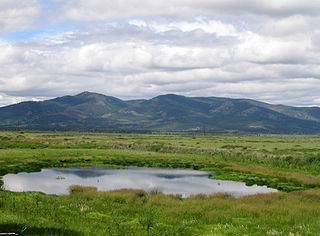
Har Us Nuur National Park is a national park in Khovd Province, Mongolia. It covers a chain of three large lakes in the Great Lakes Basin of western Mongolia. The lakes, Khar-Us Nuur, Khar Lake and Dörgön Lake are bordered by marshes and reed-beds that are an important breeding sport for birds, over 200 species of which have been identified in the park. Mount Jargalant is on the southern shore of Khar-Us. This park is distinct from Khyargas Nuur National Park, another large lake in the region, but 60 km to the north.

