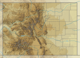
Kiowa County is a county located in the U.S. state of Colorado. As of the 2020 census, the population was 1,446, making it the fifth-least populous county in Colorado. The county seat is Eads. The county was named for the Kiowa Nation of Native Americans.

The Platte River is a major river in the State of Nebraska. It is about 310 mi (500 km) long; measured to its farthest source via its tributary, the North Platte River, it flows for over 1,050 miles (1,690 km). The Platte River is a tributary of the Missouri River, which itself is a tributary of the Mississippi River which flows to the Gulf of Mexico. The Platte over most of its length is a broad, shallow, meandering stream with a sandy bottom and many islands—a braided stream.

Two Buttes is a dual-peaked mountain in Prowers County, Colorado. The two peaks, which are the highest point in Prowers County, rise about 300 feet (91 m) above the mostly flat Great Plains that surround them, making them visible for miles. The south peak is about 30 feet (9.1 m) higher than the north one, and both are connected by a saddle.

The Arikaree River is a 156-mile-long (251 km) river in the central Great Plains of North America. It lies mostly in the American state of Colorado, draining land between the North and South Forks of the Republican River, and it flows into the North Fork in Nebraska after flowing a short distance through Kansas. It is a designated area within the Colorado Natural Areas Program to protect native and uncommon species that may be endangered or threatened.

The Dakota is a sedimentary geologic unit name of formation and group rank in Midwestern North America. The Dakota units are generally composed of sandstones, mudstones, clays, and shales deposited in the Mid-Cretaceous opening of the Western Interior Seaway. The usage of the name Dakota for this particular Albian-Cenomanian strata is exceptionally widespread; from British Columbia and Alberta to Montana and Wisconsin to Colorado and Kansas to Utah and Arizona. It is famous for producing massive colorful rock formations in the Rocky Mountains and the Great Plains of the United States, and for preserving both dinosaur footprints and early deciduous tree leaves.

Cheyenne Bottoms is a wetland in the central Great Plains of North America. Occupying approximately 41,000 acres in central Kansas, it is the largest wetland in the interior United States. The Bottoms is a critical stopping point on the Central Flyway for millions of birds which migrate through the region annually.

Vega State Park is a 1,823-acre (738 ha) Colorado state park in Mesa County, Colorado in the United States. Vega Reservoir is a fishing destination and is located at an elevation of 7,696 feet (2,346 m). Year-round recreational activities at Vega State Park include boating, hiking, snowmobiling and camping. The park was established in 1967 in cooperation with the Bureau of Reclamation which was responsible for the construction of Vega Dam and Vega Reservoir. It is located at the northeast edge of Grand Mesa National Forest in Western Colorado.
Spinney Mountain State Park is a Colorado state park located in South Park in Park County, Colorado, United States.

Keith Sebelius Lake, formerly known as Norton Reservoir, is a man-made reservoir on Prairie Dog Creek in northwest Kansas. Built and managed by the U.S. Bureau of Reclamation, it is used for flood control, irrigation, recreation, and local water supply. Prairie Dog State Park is located on its shore.

Big Sandy Creek is a 211-mile-long (340 km) tributary of the Arkansas River noted for being the location of the Sand Creek Massacre in Kiowa County. Long stretches are dry most of the time on the surface, although water still flows underground. Big Sandy Creek starts near Peyton in El Paso County, Colorado and flows through Elbert, Lincoln, Cheyenne and Kiowa counties before it joins with the Arkansas River in Prowers county east of Lamar.
Ladder Creek is a 230-mile-long (370 km) stream in the central Great Plains of North America. A tributary of the Smoky Hill River, it flows from eastern Colorado into western Kansas.
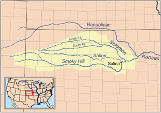
The North Fork Smoky Hill River is a river in the central Great Plains of North America. A tributary of the Smoky Hill River, it flows from eastern Colorado into western Kansas.

Cedar Bluff Reservoir is a reservoir in Trego County, Kansas, United States. Built and managed by the U.S. Bureau of Reclamation for irrigation and area water supply, it is also used for flood control and recreation. Cedar Bluff State Park is located on its shore.

Kirwin Reservoir is a reservoir in Phillips County, Kansas, United States. It is located next to the city of Kirwin in northern Kansas. The U.S. Bureau of Reclamation built it and continues to operate it for the purposes of flood control and area irrigation. The Kirwin National Wildlife Refuge lies on its shores.
John Martin Reservoir is a reservoir on the Arkansas River in Bent County in southeastern Colorado. Built and managed by the U.S. Army Corps of Engineers, it is used for flood control, irrigation, and recreation. John Martin Reservoir State Park lies on its shore.
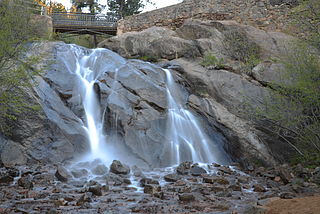
Cheyenne Creek is a stream in Colorado Springs, El Paso County, Colorado at 5,920 feet (1,800 m) in elevation. The stream is fed by the North Cheyenne Creek and South Cheyenne Creek and flows into Fountain Creek near Nevada Avenue, between Interstate 25 and the Pikes Peak Greenway trail. North Cheyenne Creek and South Cheyenne Creek flow through Teller and El Paso Counties. The source of South Cheyenne Creek is Mount Big Chief, near St. Peter's Dome, and it flows to Seven Falls.

Cheyenne Mountain is a triple-peaked mountain in El Paso County, Colorado, southwest of downtown Colorado Springs. The mountain serves as a host for military, communications, recreational, and residential functions. The underground operations center for the North American Aerospace Defense Command (NORAD) was built during the Cold War to monitor North American airspace for missile launches and Soviet military aircraft. Built deep within granite, it was designed to withstand the impact and fallout from a nuclear bomb. Its function broadened with the end of the Cold War, and then many of its functions were transferred to Peterson Air Force Base in 2006.

Adobe Creek is a tributary of the Arkansas River in southeastern Colorado, U.S.