
Makhuduthamaga Municipality is a local municipality within Sekhukhune District Municipality, in the Limpopo province of South Africa.

Albert Luthuli Municipality is a local municipality within the Gert Sibande District Municipality, in the Mpumalanga province of South Africa. It was named after Albert Luthuli. Carolina is the seat of the municipality.

Lephalale Municipality is a local municipality within the Waterberg District Municipality, in the Limpopo province of South Africa. The seat is Lephalale.

Mogalakwena Municipality is a local municipality within the Waterberg District Municipality, in the Limpopo province of South Africa. It's named after the mogalakwena river which comes from the babina Kwena fierce Nile crocodile. The seat is Mokopane. The area constitute of a cosmopolitan of different chiefdoms : mainly bakone, Lebelo kgomo, transvaal Ndebele Langa & Kekana, phokela, Lekalekale, babirwa.
Thabazimbi Municipality is a local municipality within the Waterberg District Municipality, in the Limpopo province of South Africa. The seat is Thabazimbi.

Greater Letaba Municipality is a local municipality within the Mopani District Municipality, in the Limpopo province of South Africa. The seat is Modjadjiskloof.

Ba-Phalaborwa Municipality is a local municipality within the Mopani District Municipality, in the Limpopo province of South Africa. The seat is Phalaborwa.
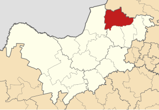
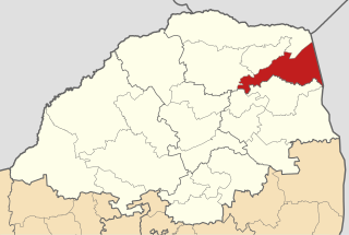
Fetakgomo Local Municipality was located in the Sekhukhune District Municipality of Limpopo province, South Africa. The seat of Fetakgomo Local Municipality was Apel. The local municipality was one of the four to have passed the 2009-10 audit by the Auditor-General of South Africa, who deemed it to have a clean administration. In 2016 it was merged with Greater Tubatse Local Municipality to form the Fetakgomo Tubatse Local Municipality.

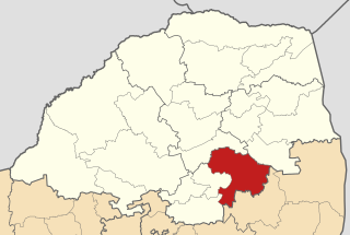
Elias Motsoaledi Municipality, formerly the Greater Groblersdal Municipality, is a local municipality within the Sekhukhune District Municipality, in the Limpopo province of South Africa. The seat of is Groblersdal. It is named in honour of the Elias Motsoaledi.

Fetakgomo Tubatse Local Municipality is located in the Sekhukhune District Municipality of Limpopo province, South Africa. In 2016, 3 August, it was merged with the Fetakgomo Local Municipality to form the Fetakgomo Tubatse Local Municipality.

Dr JS Moroka Municipality is a local municipality within the Nkangala District Municipality, in the Mpumalanga province of South Africa. The seat is Siyabuswa.
Moses Kotane Municipality is a local municipality within the Bojanala Platinum District Municipality, in the North West province of South Africa. It is named in memory of Moses Kotane. The seat of the municipality is Mogwase.

Ditsobotla Municipality is a local municipality within the Ngaka Modiri Molema District Municipality, in the North West province of South Africa. The seat of the municipality is Lichtenburg.

Sol Plaatje Municipality is a local municipality within the Frances Baard District Municipality, in the Northern Cape province of South Africa. It is named after Sol T. Plaatje. It includes the diamond mining city of Kimberley.

Kgatelopele Municipality is a local municipality within the ZF Mgcawu District Municipality, in the Northern Cape province of South Africa. Kgatelopele is a Setswana name meaning "progress".

Umzumbe Municipality is a local municipality within the Ugu District Municipality, in the KwaZulu-Natal province of South Africa. The municipality is named after the Umzumbe River. Towns within the municipal boundaries include Friedenau, KwaDweshula, St Faith’s, and Umzumbe.
Fetakgomo Tubatse Municipality is a local municipality within the Greater Sekhukhune District Municipality, in the Limpopo province of South Africa. It was established after the August 2016 local elections by merging the Fetakgomo and Greater Tubatse local municipalities.
Collins Chabane Municipality is a local municipality within the Vhembe District Municipality, in the Limpopo province of South Africa. It was established after the August 2016 local elections by merging portions of the Thulamela and Makhado local municipalities. Malamulele is the seat of the municipality.

Ray Nkonyeni Municipality is a local municipality within the Ugu District Municipality in South Africa. It is located on the south coast of KwaZulu-Natal. It was established after the August 2016 local elections by merging the Ezinqoleni and Hibiscus Coast local municipalities. As of 2022 it has a population of 362,134.
The Greater Tzaneen Local Municipality is a Local Municipality in Limpopo, South Africa. The council consists of sixty-nine members elected by mixed-member proportional representation. Thirty-five councillors are elected by first-past-the-post voting in thirty-five wards, while the remaining thirty-four are chosen from party lists so that the total number of party representatives is proportional to the number of votes received. In the election of 1 November 2021 the African National Congress (ANC) won a majority of 51 seats.


