Greenbrier River Watershed Association

Last updated
C&O Railway pillars of the Second Creek Tunnel along the Greenbrier River SecondCreekPillars.jpg
C&O Railway pillars of the Second Creek Tunnel along the Greenbrier River

The Greenbrier River Watershed Association (GRWA) is one of the oldest watershed associations in the state of West Virginia, founded in 1990. It has supported the creation of other watershed associations throughout the state and maintains a policy of "upstream courtesy" and "downstream courtesy" with its neighbors.

Contents

Projects

The GRWA is a 501(c)(3) nonprofit that partners with other environmental nonprofits, government organizations, and like-minded groups to promote the values of the watershed in the hopes that the public will understand its unique riparian resources and thus recognize its worth. The Board of the GRWA is composed of cavers, farmers, developers, teachers, and other diverse individuals that unite in their love for the Greenbrier. They work with schools and civic groups to teach classes, organize field trips, and support similar organizations that protect the watershed.

Outreach

Unlike the majority of the watersheds in West Virginia, the GRWA's webpage is centered around the watershed itself, not the organization. It survives on grants and public support (primarily membership donations), to assist the public with issues such as nonpoint source pollution, water quality, water quantity, protection of forests to alleviate pollution, prevention of substandard and/or illegal developments, injection wells, using sinkholes and cave systems for trash disposal, leaking septic tanks, water sampling, straightpipes, and wastewater treatment plant issues. The Clean Water Act of 1972 has enabled the GRWA to help citizens seek legal, effective methods of improving their waters for the benefit of public health.

Riffles is the GRWA newsletter, published on a quarterly basis. Submissions from members are strongly encouraged and nearly a third of its members are out of state. Riffles are the shallow, oxygen-rich rapids of a river, which is as full of diverse life as a coral reef but often taken for granted and overlooked.

Members may join on a family membership ($30), or single ($25) or youth ($10). [1]

Geography

The Greenbrier River Watershed Association currently resides in Lewisburg, West Virginia, at 120 W. Washington Street. The office serves the entirety of the Greenbrier River Watershed. A second watershed, Friends of the Lower Greenbrier River, [2] split off from the GRWA to concentrate on riparian issues in the lower half of the watershed. Both are within the West Virginia Southern Basin, which drains to the New River at Hinton in Summers County. Their primary state assistance and consultation comes from the West Virginia Department of Environmental Protection's Southern Basin Coordinator, Jennifer Dupree.

Counties and subwatersheds

Pocahontas County Greenbrier County Monroe County Summers County
Knapp Creek Milligan Creek Second Creek Pence Springs
Swago Creek Spring Creek Kitchen Creek Eagle Branch
East Fork Muddy Creek Plankcabin Creek Big Creek

Pocahontas County: Birthplace of Rivers

The Greenbrier River begins at Durbin in Pocahontas County, but the watershed is involved with the upper drainage portions above Durbin, which includes places like Blister Swamp. It flows through the center of Pocahontas County, "the Birthplace of Rivers." Pocahontas County is sparsely populated, due to the Monongahela National Forest. This legally designated National Forest supports a great deal of the clean water within the watershed, and water quality degrades once the river flows out of the Forest's territory and into the more populated Greenbrier County. The spring Great Greenbrier River Race in Marlinton and summer's Durbin Days in Durbin draws large crowds every year. Pocahontas County contains much of the Greenbrier River Trail, which is the longest Rail Trail in West Virginia. [3] The first USGS flow gauge station for the watershed is in the town of Buckeye involving Swago Creek. [4]

Greenbrier County: Land of Karst

The eastern half of Greenbrier County where the watershed rests is one of the world's densest karst stratas in the world with, "The Great Savannah" where sinkholes average at 18 km2. [5] Its water is threatened by development and ignorance of karst issues. Despite the fact that its sensitivity is a matter of record, many people claim ignorance of karst and the county government has no existing bond of commitment for its developers that would guarantee a building project will not be affected by the shifting caverns and sinkholes. The western side hosts the new Meadow River Watershed. Greenbrier County is known for its trout waters, farmland, rising development, historic 1812-and Civil War saltpetre caverns [6] and tour caves: Lost World Caverns and Organ Cave, Inc. Many important Ice Age fossil discoveries have been found within the watershed here. Greenbrier County hosts the Riders of the Flood Outdoor Amphitheatre in Ronceverte, the State Fair of West Virginia and the Freshwater Folk Festival at the National Fish Hatchery at White Sulphur Springs, [7] and the GRWA tries to keep its presence at both events for outreach.

Monroe County: Land of Sinks

Monroe County is a rich, agriculturally blessed county with fine apple orchards, wineries, trout water, historic springs, farmland, and saltpeter caves. Since settler times it has been called "the land of sinks" for its many sinkholes. One community is called Sinks Grove because of this terrain. It contains the Second Creek Watershed, which is maintained by Friends of THE Second Creek Watershed. [8] The birthplace of American paleontology began in the late 18th century with the discovery of the Megalonyx Jeffersonii (Thomas Jefferson's Three-toed Sloth) in its Haynes Cave. Haynes Cave is believed to be approximately 2 to 5 million years old. [9] Monroe County has the USGS station on its side of the town of Alderson, West Virginia, where the public gleans much useful data about temperature, pH, flow, and dissolved oxygen. Much work has been launched in efforts to study the karstic hydrology of this county. [10] [11] Recently the entire Second Creek Watershed was designated an historic watershed by the state of West Virginia.

Summers County: Confluence of Rivers

Summers County is the least karstic of all the watershed counties, with only six karstic springs and rockledges outnumbering caves. Summers County is warm, with weather influenced by the New River and many vernal pools and streams feed the lower Greenbrier in the summer. Native American summer settlements grew crops along the long, flat floodplains in areas like Pence Springs. The last USGS station is in the town of Hilldale. [12] The Greenbrier enters the Three Rivers Confluence at Hinton where the waters of the Bluestone River, the New River, and the Greenbrier River mix. Hinton hosts a Water Festival every year. Although the Greenbrier flows into the New River at Hinton, New River biota such as the lamprey cannot travel upstream because of Sandstone Falls, the 30th-largest waterfall in the world. This helps preserve the integrity of the Greenbrier's freshwater species. The National Park Service celebrates the role of the tributaries of the New River at the Sandstone Visitors Center in Sandstone, West Virginia.

Of Note

The Greenbrier provides an estimated 30% of all the water in the New River.

The state's oldest Ginkgo Biloba tree is a 133-year-old specimen planted in Lewisburg's New River Community and Technical College campus. [13]

Railroads

Two of the three Historic Railroads in West Virginia are within the Greenbrier River Watershed: The Cass Scenic Railroad State Park and the Durbin and Greenbrier Valley Railroad. Unused railroad tracks have been restored into a 79-mile Greenbrier River Trail. [14]

Notes

  1. "GRWA". Greenbrierriver.org. Retrieved 2011-01-28.
  2. "Friends of the Lower Greenbrier River". Lowergreenbrierriver.org. Retrieved 2011-01-28.
  3. Greenbrier River Rail Trail
  4. "USGS Real-Time Water Data for USGS 03182500 GREENBRIER RIVER AT BUCKEYE, WV". Waterdata.usgs.gov. 1939-02-27. Retrieved 2011-01-28.
  5. "The Secret World of Greenbrier Valley: Agricultural Runoff and Water Quality". stormh2o.com. Retrieved 2011-01-28.
  6. McKinney, Tim. "The Civil War in Greenbrier County, West Virginia, 2004 Quarrier Press.
  7. "US Fish & Wildlife Service Redirect page". Fws.gov. Retrieved 2011-01-28.
  8. "Friends Of THE Second Creek Inc". Secondcreekwv.tripod.com. 2009-05-23. Retrieved 2011-01-28.
  9. Swezey, Christopher S.; Piatak, Nadine M.; Grady, Frederick V.; Hackley Paul C. (June 2007), Some Notes on the Geology of Haynes Cave, The West Virginia Caver, Vol. 25, No. 3, page 12-15.
  10. "USGS Real-Time Water Data for USGS 03183500 GREENBRIER RIVER AT ALDERSON, WV". Waterdata.usgs.gov. 1929-10-15. Retrieved 2011-01-28.
  11. "U. of Akron, Geology, Natasha Demrovsky". .uakron.edu. Archived from the original on 2009-01-07. Retrieved 2011-01-28.
  12. "USGS Real-Time Water Data for USGS 03184000 GREENBRIER RIVER AT HILLDALE, WV". Waterdata.usgs.gov. 1936-03-18. Retrieved 2011-01-28.
  13. "Bluefield State College - October News Releases". Bluefieldstate.edu. 2005-10-26. Archived from the original on 2006-09-03. Retrieved 2011-01-28.
  14. Cass Scenic Railroad State Park.

Related Research Articles

Karst Topography from dissolved soluble rocks

Karst is a topography formed from the dissolution of soluble rocks such as limestone, dolomite, and gypsum. It is characterized by underground drainage systems with sinkholes and caves. It has also been documented for more weathering-resistant rocks, such as quartzite, given the right conditions. Subterranean drainage may limit surface water, with few to no rivers or lakes. However, in regions where the dissolved bedrock is covered or confined by one or more superimposed non-soluble rock strata, distinctive karst features may occur only at subsurface levels and can be totally missing above ground.

Monroe County, West Virginia County in West Virginia, United States

Monroe County is a county in the U.S. state of West Virginia. As of the 2020 census, the population was 12,376. Its county seat is Union.

Ronceverte, West Virginia City in West Virginia, United States

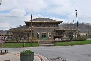
Ronceverte is a city in Greenbrier County, West Virginia, United States, on the Greenbrier River. The population was 1,765 at the 2010 census.

Durbin, West Virginia Town in West Virginia, United States

Durbin is a town in Pocahontas County, West Virginia, United States. The population was 293 at the 2010 census.

Greenbrier River

The Greenbrier River is a tributary of the New River, 162 miles (261 km) long, in southeastern West Virginia, in the United States. Via the New, Kanawha and Ohio rivers, it is part of the watershed of the Mississippi River, draining an area of 1,656 square miles (4,290 km2). It is one of the longest rivers in West Virginia.

Cass Scenic Railroad State Park State Park in Cass and Pocahontas counties, West Virginia

Cass Scenic Railroad State Park is a state park and heritage railroad located in Cass, Pocahontas County, West Virginia.

West Virginia Route 12 is a north–south route located in the southern portion of the U.S. state of West Virginia. The southern terminus of the route is at U.S. Route 219 in Peterstown, Monroe County, less than 300 yards (270 m) from the Virginia state line. It compromises a portion of the Farm Heritage Road byway between Peterstown and West Virginia Route 122. The northern terminus of the route is at U.S. Route 60 in Alta, Greenbrier County, near Interstate 64 exit 161.

Cranberry River (West Virginia)

The Cranberry River is a tributary of the Gauley River located in southeastern West Virginia in the United States. It is a part of the Mississippi River watershed, by way of the Gauley, Kanawha, and Ohio Rivers, draining an area of 74 square miles (192 km2).

Greenbrier River Trail Long-distance hiking trail in the United States

The Greenbrier River Trail (GRT), is a lineal state park comprising a 77.1-mile (124.1 km) rail trail between North Caldwell and Cass in eastern West Virginia.

The West Virginia spring salamander is a species of salamander in the family Plethodontidae. It is endemic to West Virginia, the United States.

Durbin and Greenbrier Valley Railroad

The Durbin and Greenbrier Valley Railroad is a heritage and freight railroad in the U.S. states of Virginia and West Virginia. It operates the West Virginia State Rail Authority-owned Durbin Railroad and West Virginia Central Railroad, as well as the Shenandoah Valley Railroad in Virginia.

Pence Springs, West Virginia Unincorporated community in West Virginia, United States

Pence Springs is an unincorporated community in Summers County, West Virginia, United States. It lies along the Greenbrier River to the east of the city of Hinton, the county seat of Summers County. Its elevation is 1,539 feet, and it is located at 37°40′41″N80°43′30″W. It had a post office with the ZIP code 24962 until it was closed in October 2011.

The West Virginia Speleological Survey (WVaSS) is a speleological organization and ongoing cave survey program that has gathered information and published about West Virginia caves and karst since 1967.

Fort Spring is an unincorporated community and town in Greenbrier County, West Virginia, United States. It is situated along the Greenbrier River within the Greenbrier River Watershed. It was once a substantial portion of the Chesapeake and Ohio railway by way of the Gravel Girtie route from Hinton in Summers County to Clifton Forge, Virginia. The name is derived from its main export; Mississippian limestone from Snowflake Quarry sent to Clifton Forge. The main road going through the small town was once the original rail line, but was moved.

Clayton is an unincorporated community in Summers County, West Virginia, United States. The community was first settled in 1813. Clayton once had a post office, which opened in 1879 and closed in 1959.

Haynes Cave is a cave within the Greenbrier River watershed in West Virginia. It sits within the complex hydrology of the historic Second Creek watershed in Monroe County.

The St. Lawrence Boom and Manufacturing Company was a lumber company based in Ronceverte, West Virginia. It was founded in 1802 by a Colonel Cecil C. Clay, a former US Army Brigadier-General from Philadelphia.

Lowell is an unincorporated community in Summers County, West Virginia, United States. Lowell is located on the Greenbrier River, east of Hinton and southwest of Alderson. The community was first settled in 1770 and is the oldest community in Summers County.

Sinks Grove, West Virginia Unincorporated community in West Virginia, United States

Sinks Grove is an unincorporated community in Monroe County, West Virginia, United States. Sinks Grove is located on West Virginia Route 3, north of Union. Sinks Grove has a post office with ZIP code 24976.

Thornwood is an unincorporated community in Pocahontas County, West Virginia, United States. Thornwood is on the East Fork of the Greenbrier River. US Route 250 passes approximately one-half mile to the south. It is approximately 5 miles (8.0 km) east-northeast of Durbin.

References