
Roxbury is a neighborhood within the city of Boston, Massachusetts.
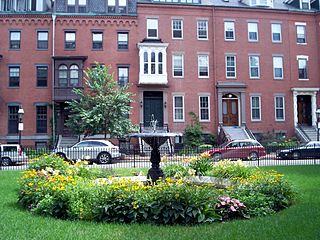
The South End is a neighborhood of Boston, Massachusetts. It is bordered by Back Bay, Chinatown, and Roxbury. It is distinguished from other neighborhoods by its Victorian style houses and the many parks in and around the area. The South End is the largest intact Victorian row house district in the country, as it is made up of over 300 acres. Eleven residential parks are contained within the South End. In 1973, the South End was listed in the National Register of Historic Places. Much of the South End was originally marshlands in Boston's South Bay. After being filled in, construction of the neighborhood began in 1849.

Key bus routes of the Massachusetts Bay Transportation Authority (MBTA) system are 15 routes that have high ridership and higher frequency standards than other bus lines, according to the 2004 MBTA Service Policy. Together, they account for roughly 40% of the MBTA's total bus ridership. These key bus routes ensure basic geographic coverage with frequent service in the densest areas of Boston, and connect to other MBTA services to give access to other areas throughout the region.

Nubian station is a ground-level bus station located in Nubian Square in the Roxbury neighborhood of Boston, Massachusetts, United States. It is a transfer point between 18 Massachusetts Bay Transportation Authority (MBTA) bus routes, including two Silver Line bus rapid transit lines and 16 local MBTA bus routes. Like all MBTA bus stops, Nubian is fully accessible.

The West End is a neighborhood of Boston, Massachusetts, bounded generally by Cambridge Street to the south, the Charles River to the west and northwest, North Washington Street on the north and northeast, and New Sudbury Street on the east. Beacon Hill is to the south, North Point is across the Charles River to the north, Kendall Square is across the Charles River to the west, and the North End is to the east. A late 1950s urban renewal project razed a large Italian and Jewish enclave and displaced over 20,000 people in order to redevelop much of the West End and part of the neighboring Downtown neighborhood. Today, much of the original West End is non-residential, including part of Government Center as well as much of Massachusetts General Hospital and several high rise office buildings.

Mission Hill is a ¾ square mile, primarily residential neighborhood of Boston that borders Roxbury, Jamaica Plain, Brookline and Fenway-Kenmore. It is home to several hospitals and universities, including Brigham and Women's Hospital and New England Baptist Hospital. Mission Hill is known for its brick row houses and triple decker homes of the late 19th century. The population was estimated at 15,883 in 2011.

Roxbury Crossing is a rapid transit station in Boston, Massachusetts. It serves the MBTA Orange Line, and is located on Tremont Street in the Mission Hill neighborhood. The current station opened in 1987 as part of the renovation and relocation of the southern Orange Line. Like all stations on the Orange Line, Roxbury Crossing is accessible.

Nubian Square is the primary commercial center of the Roxbury neighborhood of Boston, Massachusetts, located at the intersection of Dudley Street and Washington Street. It has long been the center of African American culture in Boston, prior to which the area was primarily Jewish.
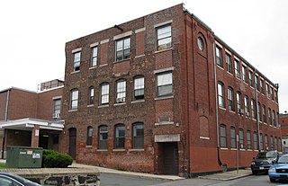
The Berger Factory is a historic factory building at 37 Williams Street in Boston, Massachusetts. Built in 1902, it was home to one of the nation's first manufacturers of precision engineering and surveying instruments, and a surviving example of Roxbury's late 19th-century industrial development. It was listed on the National Register of Historic Places in 1980, and now houses residences.

The Dillaway School is an historic school at 16-20 Kenilworth Street in Boston, Massachusetts. The school was built in 1882 to a design by George Albert Clough, the city's first official architect, and is his only surviving school design in the city. The building was listed on the National Register of Historic Places in 1980, and included in the Roxbury Highlands Historic District in 1989. The building has been converted to residential use.

The Frederick Douglass Square Historic District is a historic district roughly bounded by Hammond Street, Cabot Street, Windsor Street, and Westminster Street, in the Lower Roxbury area of Boston, Massachusetts. It covers a 5-acre (2.0 ha) that is a remarkably well-preserved and cohesive residential development created as the result of one of Boston's many land-reclamation projects in the 19th century. This area, originally salt marshes that flooded at high tide, was at first gradually filled in as the Boston Neck was widened with the construction of Tremont Street and railroad lines. The Tremont Improvement Company acquired a remnant portion of the salt marshes by the early 1860s, and built a series of single-family row houses on the land that resulted from filling it in. The district includes most of the residential properties on Warwick, Greenwich, and Sussex Streets, as well as clusters of properties on adjacent streets.
Dudley Station Historic District is a historic district on Washington, Warren, and Dudley Streets in the Roxbury neighborhood of Boston, Massachusetts, United States. The central feature of the district is Dudley Square station, a Beaux Arts/French Renaissance structure designed by Alexander Wadsworth Longfellow and built by the Boston Elevated Railway in 1901. It is one of the best-preserved BERy stations remaining.

The Lower Roxbury Historic District is a historic district encompassing an isolated pocket of 1890s mixed residential-commercial property in the lower Roxbury neighborhood of Boston, Massachusetts. Bounded by Tremont, Columbus, and Burke Streets and St. Cyprian's Place, the area contains a well-kept collection of architect designed buildings that survived late 20th-century urban redevelopment. The district was added to the National Register of Historic Places in 1994.

Mount Pleasant Historic District is a historic district encompassing a cluster of well-preserved 19th-century residential buildings on Forest Street and Mount Pleasant Avenue in the Roxbury neighborhood of Boston, Massachusetts. First developed in 1833, it was one Roxbury's first speculative residential subdivision developments. The district features Greek Revival, Italianate, and Romanesque architecture, and was added to the National Register of Historic Places in 1989.

Fort Hill is a 0.4 square mile neighborhood and historic district of Roxbury, in Boston, Massachusetts. The approximate boundaries of Fort Hill are Malcolm X Boulevard on the north, Washington Street on the southeast, and Columbus Avenue on the southwest.

The Governor Shirley Square Historic District encompasses a cluster of civic, residential, and religious buildings at the junction of Dudley, Hampden, and Dunmore Streets in the Roxbury neighborhood of Boston, Massachusetts. Named for colonial governor William Shirley in 1913, the square was developed in the 1870s and 1880s as a major locus of civic development after the city of Roxbury was annexed to Boston in 1868. The district was listed on the National Register of Historic Places in 2016.

The Ascension-Caproni Historic District encompasses a mixed collection of late 19th and early 20th century architecture along Washington, Newcomb, and Thorndike Streets in the Roxbury neighborhood of Boston, Massachusetts. Including religious, residential, commercial, and industrial buildings, it encapsulates the area's transition from industrial to residential uses between about 1850 and 1930. The district was listed on the National Register of Historic Places in 2019.

The Intervale Street-Blue Hill Avenue Historic District is a historic district encompassing a densely built residential area in the Dorchester neighborhood of Boston, Massachusetts. Centered on a stretch of Intervale Street near Blue Hill Avenue, the area was developed in the late 19th and early 20th centuries during a major Jewish migration, and includes a fine sample of Colonial Revival architecture. The district was listed on the National Register of Historic Places in 2020.
The Crawford Street Historic District encompasses a collection of primarily residential apartment houses on Crawford Street between Elm Hill Avenue and Warren Street in the Roxbury neighborhood of Boston, Massachusetts. The area was developed in the late 19th and early 20th centuries, and features well-preserved wood frame single and multi-family residences from that period, as well as the city's only extant Brutalist style branch library building. The district was listed on the National Register of Historic Places in 2020.

The Elm Hill Park Historic District is a historic district encompassing a small residential area in the Roxbury neighborhood of Boston, Massachusetts. It encompasses a residential development created in the early 20th century, including fine examples of Colonial Revival and Queen Anne wood-frame construction, as well as a series of brick Romanesque apartment houses. The district was listed on the National Register of Historic Places in 2021.


