Grenville, New Mexico

Last updated

Grenville, New Mexico
Union County New Mexico Incorporated and Unincorporated areas Grenville Highlighted.svg
Location of Grenville, New Mexico
Usa edcp location map.svg
Red pog.svg
Grenville, New Mexico
Location in the United States
Coordinates: 36°35′36″N103°36′52″W / 36.59333°N 103.61444°W / 36.59333; -103.61444
Country United States
State New Mexico
County Union
Area
[1]
  Total0.38 sq mi (0.98 km2)
  Land0.38 sq mi (0.98 km2)
  Water0.00 sq mi (0.00 km2)
Elevation
5,981 ft (1,823 m)
Population
 (2020) [2]
  Total22
  Density58.05/sq mi (22.43/km2)
Time zone UTC-7 (Mountain (MST))
  Summer (DST) UTC-6 (MDT)
ZIP code
88424
Area code 575
FIPS code 35-30770
GNIS feature ID0928315

Grenville is a village in Union County, New Mexico, United States. The population was 38 at the 2010 census.

Contents

Geography

Grenville is located at 36°35′36″N103°36′52″W / 36.59333°N 103.61444°W / 36.59333; -103.61444 (36.593305, -103.614552). [3]

According to the United States Census Bureau, the village has a total area of 0.6 square miles (1.6 km2), all land.

Demographics

Historical population
CensusPop.Note
1930 231
1940 143−38.1%
1950 102−28.7%
1960 55−46.1%
1970 21−61.8%
1980 3985.7%
1990 24−38.5%
2000 254.2%
2010 3852.0%
2020 22−42.1%
U.S. Decennial Census [4] [2]

As of the census [5] of 2000, there were 25 people, 9 households, and 6 families residing in the village. The population density was 39.8 inhabitants per square mile (15.4/km2). There were 14 housing units at an average density of 22.3 units per square mile (8.6 units/km2). The racial makeup of the village was 100.00% White.

There were 9 households, out of which 33.3% had children under the age of 18 living with them, 66.7% were married couples living together, and 33.3% were non-families. 33.3% of all households were made up of individuals, and 33.3% had someone living alone who was 65 years of age or older. The average household size was 2.78 and the average family size was 3.67.

In the village, the population was spread out, with 32.0% under the age of 18, 4.0% from 18 to 24, 20.0% from 25 to 44, 16.0% from 45 to 64, and 28.0% who were 65 years of age or older. The median age was 40 years. For every 100 females, there were 108.3 males. For every 100 females age 18 and over, there were 70.0 males.

The median income for a household in the village was $54,375, and the median income for a family was $58,125. Males had a median income of $0 versus $0 for females. The per capita income for the village was $21,536. None of the population and none of the families were below the poverty line.

Related Research Articles

<span class="mw-page-title-main">Union County, New Mexico</span> County in New Mexico, United States

Union County is the northeasternmost county in the U.S. state of New Mexico. As of the 2020 census, the population was 4,079, making it the fourth-least populous county in New Mexico. Its county seat is Clayton. The county was formed in 1894. Union County borders Colorado to the north, and Oklahoma and Texas to the east.

<span class="mw-page-title-main">White City, Illinois</span> Village in Illinois, United States

White City is a village in Macoupin County, Illinois, United States. The population was 212 as of the 2020 census.

<span class="mw-page-title-main">Olmsted, Illinois</span> Village in Illinois, United States

Olmsted is a village in Pulaski County, Illinois, along the Ohio River. The population was 299 at the 2000 census.

<span class="mw-page-title-main">Roxbury, Maine</span> Town in the state of Maine, United States

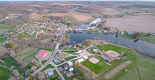
Roxbury is a town in Oxford County, Maine, United States. The population was 361 at the 2020 census. Ellis Pond is popular with recreational fishermen.

<span class="mw-page-title-main">Dallas Township, Michigan</span> Civil township in Michigan, United States

Dallas Township is a civil township of Clinton County in the U.S. state of Michigan. The population was 2,411 at the 2020 census. The township was established in 1845 from a section of Lebanon Township and named for vice president George M. Dallas.

<span class="mw-page-title-main">Lakeland Village, California</span> Census-designated place in California, United States

Lakeland Village is a census-designated place (CDP) in Riverside County, California, United States. The population was 11,541 at the 2010 census, more than double the 5,626 reported at the 2000 census.

<span class="mw-page-title-main">Mesick, Michigan</span> Village in Michigan, United States

Mesick is a village in Wexford County in the U.S. state of Michigan. The population was 397 at the 2020 census. The majority of the village is located within Springville Township with a very small portion extending east into Antioch Township.

<span class="mw-page-title-main">Gunn City, Missouri</span> Village in Missouri, United States

Gunn City is a village in Cass County, Missouri, United States. The population was 118 at the 2010 census. It is part of the Kansas City metropolitan area.

<span class="mw-page-title-main">Rutledge, Missouri</span> Village in Missouri, United States

Rutledge is a village in Scotland County, Missouri, United States. As of the 2020 census, its population was 86.

<span class="mw-page-title-main">Lewiston, Nebraska</span> Village in Nebraska, United States

Lewiston is a village in northwest Pawnee County, Nebraska, United States. The population was 54 at the 2020 census.

<span class="mw-page-title-main">Cedar Bluffs, Nebraska</span> Village in Saunders County, Nebraska, United States

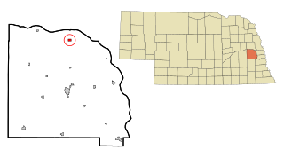
Cedar Bluffs is a village in Saunders County, Nebraska, United States. The population was 615 at the 2020 census. Cedar Bluffs was a point on the Mormon, Oregon, and California Trails.

<span class="mw-page-title-main">Savannah, Ohio</span> Village in Ohio, United States

Savannah is a village in Ashland County, Ohio, United States. The population was 329 at the 2020 census.

<span class="mw-page-title-main">Salineville, Ohio</span> Village in Ohio, United States

Salineville is a village in southwestern Columbiana County, Ohio, United States. The population was 1,206 at the 2020 census. It is part of the Salem micropolitan area, about 20 miles (32 km) northwest of Steubenville and 34 miles (55 km) southwest of Youngstown.

<span class="mw-page-title-main">Kirkersville, Ohio</span> Village in Ohio, United States

Kirkersville is a village in Licking County, Ohio, United States, along the South Fork of the Licking River. The population was 471 at the 2020 census.

<span class="mw-page-title-main">Summerfield, Ohio</span> Village in Ohio, United States

Summerfield is a village in Noble County, Ohio, United States. The population was 237 at the 2020 census, down from 254 at the 2010 census.

<span class="mw-page-title-main">Mount Eaton, Ohio</span> Village in Ohio, United States

Mount Eaton is a village in Wayne County, Ohio, United States. The population was 171 at the 2020 census.

<span class="mw-page-title-main">Opdyke West, Texas</span> Town in Texas, United States

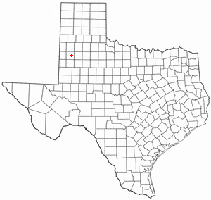
Opdyke West is a town in Hockley County, Texas, United States. The population was 174 at the 2010 census. It takes its name from the nearby community of Opdyke, founded in 1925, which was named either for Charles W. Opdyke, railroad director, or for the family of W. A. Dykes, who established the first gin in the area by 1937. Opdyke West was incorporated in 1984.

<span class="mw-page-title-main">Reese Center, Texas</span> Former CDP in Texas, United States

Reese Center is an unincorporated community and former census-designated place (CDP) in Lubbock County, Texas, United States. The population was 42 at the 2000 census. Its population was not recorded separately for the 2010 census. It is part of the Lubbock Metropolitan Statistical Area.

<span class="mw-page-title-main">Newburg, Wisconsin</span> Village in Ozaukee and Washington counties, Wisconsin

Newburg is a village in Ozaukee and Washington counties in the U.S. state of Wisconsin. The population was 1,254 at the 2010 census. Of this, 1,157 were in Washington County, and only 97 were in Ozaukee County.

<span class="mw-page-title-main">Cazenovia, Wisconsin</span> Village in Wisconsin, United States

Cazenovia is a village in Richland and Sauk Counties in the U.S. state of Wisconsin. The population was 318 at the 2010 census. Of this, 314 were in Richland County, and only 4 were in Sauk County.

References

  1. "ArcGIS REST Services Directory". United States Census Bureau. Retrieved October 12, 2022.
  2. 1 2 "Census Population API". United States Census Bureau. Retrieved October 12, 2022.
  3. "US Gazetteer files: 2010, 2000, and 1990". United States Census Bureau. February 12, 2011. Retrieved April 23, 2011.
  4. "Census of Population and Housing". Census.gov. Retrieved June 4, 2015.
  5. "U.S. Census website". United States Census Bureau . Retrieved January 31, 2008.