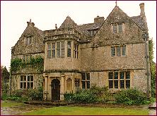
St Catherine's Court is a manor house in a secluded valley north of Bath, Somerset, England. It is a Grade I listed property. The gardens are Grade II* listed on the Register of Historic Parks and Gardens of special historic interest in England.
Eaton Hall is the country house of the Duke of Westminster. It is 1 mile (2 km) south of the village of Eccleston, in Cheshire, England. The house is surrounded by its own formal gardens, parkland, farmland and woodland. The estate covers about 10,872 acres (4,400 ha).
Combe Down is a village on the outskirts of Bath, England, in the Bath and North East Somerset unitary authority area, within the ceremonial county of Somerset.

East Harptree is a village and civil parish in Somerset, England. It is situated 5 miles (8.0 km) north of Wells and 15 miles (24.1 km) south of Bristol, on the northern slope of the Mendip Hills overlooking the Chew Valley. The parish has a population of 644. The parish includes the hamlet of Coley.
Clutton is a village and civil parish on the eastern edge of the affluent Chew Valley, close to the Cam Brook river, in the Bath and North East Somerset Council area, within the ceremonial county of Somerset, England. The village lies east of the A37 road between Bath and Shepton Mallet, and is 9 miles (14 km) from Bristol and Bath, and 11 miles (18 km) from Wells. Close by are the villages of Temple Cloud and High Littleton. The town of Midsomer Norton is 5 miles (8 km) away. The parish, which includes the hamlets of Clutton Hill and Northend, had a population of 1,602 in 2011.

The Royal National Hospital for Rheumatic Diseases is a small, specialist NHS hospital on the Royal United Hospital (RUH) site in the northwestern outskirts of Bath, England.

The Grade I listed buildings in Somerset, England, demonstrate the history and diversity of its architecture. The ceremonial county of Somerset consists of a non-metropolitan county, administered by Somerset County Council, which is divided into five districts, and two unitary authorities. The districts of Somerset are West Somerset, South Somerset, Taunton Deane, Mendip and Sedgemoor. The two administratively independent unitary authorities, which were established on 1 April 1996 following the breakup of the county of Avon, are North Somerset and Bath and North East Somerset. These unitary authorities include areas that were once part of Somerset before the creation of Avon in 1974.
Widcombe is a district of Bath, England, immediately south-east of the city centre, across the River Avon.

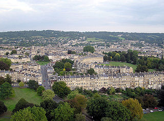
Bath and North East Somerset is a unitary authority created on 1 April 1996, following the abolition of the County of Avon, which had existed since 1974. Part of the ceremonial county of Somerset, Bath and North East Somerset occupies an area of 220 square miles (570 km2), two-thirds of which is green belt. It stretches from the outskirts of Bristol, south into the Mendip Hills and east to the southern Cotswold Hills and Wiltshire border. The city of Bath is the principal settlement in the district, but BANES also covers Keynsham, Midsomer Norton, Radstock and the Chew Valley. The area has a population of 170,000, about half of whom live in Bath, making it 12 times more densely populated than the rest of the area.

Partis College on Newbridge Hill, Bath, Somerset, England, was built as large block of almshouses between 1825 and 1827. It has been designated as a Grade I listed building.

North Parade in Bath, Somerset, England is a historic terrace built around 1741 by John Wood, the Elder. Several of the houses have been designated as Grade I listed buildings.

South Parade in Bath, Somerset, England, is a historic terrace built around 1743 by John Wood, the Elder. All of the houses have been designated as Grade I listed buildings.

Stall Street in Bath, Somerset, England was built by John Palmer between the 1790s and the first decade of the 19th century. The buildings which form an architectural group have listed building status and are now occupied by shops and offices.

Bathwick Hill in Bath, Somerset, England is a street lined with historic houses, many of which are designated as listed buildings. It climbs south east from the A36 towards the University of Bath on Claverton Down, providing views over the city.

Kingsmead Square in Bath, Somerset, England was laid out by John Strahan in the 1730s. Many of the houses are listed buildings.
The buildings and architecture of Bath, a city in Somerset in the south west of England, reveal significant examples of the architecture of England, from the Roman Baths, to the present day. The city became a World Heritage Site in 1987, largely because of its architectural history and the way in which the city landscape draws together public and private buildings and spaces. The many examples of Palladian architecture are purposefully integrated with the urban spaces to provide "picturesque aestheticism". In 2021, the city was added to a second World Heritage Site, a group of historic spa towns across Europe known as the "Great Spas of Europe". Bath is the only entire city in Britain to achieve World Heritage status, and is a popular tourist destination.

Kelston Park is an 18th-century country house in the village of Kelston, approximately 3 miles from Bath in North East Somerset, England. Altogether the house and gardens of Kelston Park cover an area of approximately 75 hectares. The house has been designated as a Grade II* listed building, and the garden is Grade II* listed in the National Register of Historic Parks and Gardens.
Ralli Hall is a community centre, events venue, theatre stage, business hub and impressive main hall in Hove, part of the English coastal city of Brighton and Hove. Built in 1913 as a memorial to Stephen Ralli, a member of a wealthy Greek family who had donated money to many causes throughout Brighton and Hove, it was used for about 60 years as a church hall linked to Hove's parish church. The Brighton & Hove Jewish community subsequently bought it, and in 1976 it came back into use as a community and social centre for Jewish and other groups. The Wrenaissance-style brick structure occupies a prominent corner site in a conservation area and provides a visual contrast to the older villas around it. English Heritage has listed the building at Grade II for its architectural and historical importance.

Tower House is a former private house in the Withdean area of the English coastal city of Brighton and Hove. Built in 1902 for a former jeweller to King Edward VII, it remained in private ownership until it was converted into flats and a daycare centre in 1988. It is one of the few large houses and villas to survive in the high-class Withdean area—many were demolished in favour of blocks of flats after World War II—and it has been described as "Brighton's finest example of a grand Edwardian house". English Heritage has listed the building at Grade II for its architectural and historical importance.

The Crescent is a street in Taunton, a town in the English county of Somerset. Construction began in 1807, during a period of extensive redevelopment in the town, driven by the Market House Society and the Member of Parliament Sir Benjamin Hammet. Lined on the eastern side by a Georgian terrace, the street follows a shallow crescent shape, broken in the middle by Crescent Way and a bit further south by St George's Place. It links Upper High Street, at its southern end, with Park Street and Tower Street to the north. On the western side, Somerset County Council have their offices in the County Hall, erected in 1935, and extended in the 1960s. The Georgian terrace, the Masonic Hall, and the County Hall are recorded in the National Heritage List for England as listed buildings.

